Barnim (original) (raw)
From Wikipedia, the free encyclopedia
District in Brandenburg, Germany
| Barnim | |
|---|---|
| District | |
 Flag Flag Coat of arms Coat of arms |
|
 |
|
| Country | Germany |
| State | Brandenburg |
| Capital | Eberswalde |
| Government | |
| • District admin. | Daniel Kurth (SPD) |
| Area | |
| • Total | 1,494 km2 (577 sq mi) |
| Population (31 December 2023)[1] | |
| • Total | 192,776 |
| • Density | 129.0/km2 (334.2/sq mi) |
| Time zone | UTC+01:00 (CET) |
| • Summer (DST) | UTC+02:00 (CEST) |
| Vehicle registration | BAR, BER, EW |
| Website | www.barnim.de |
Barnim (German pronunciation: [ˈbaʁnɪm] ⓘ) is a district in Brandenburg, Germany. It is bounded by (from the east and clockwise) Poland, the district of Märkisch-Oderland, the city state of Berlin and the districts of Oberhavel and Uckermark.
The name "Barnim" emerged in the 13th century and was applied to a large forest region east of the Havel and north of the Spree on the homonymous plateau, where noblemen used to hunt. The present district is roughly identical with, but somewhat smaller than this historical region.
The district was established in 1993 by merging the former districts of Bernau and Eberswalde.
Barnim extends from the Oder River to the outskirts of Berlin. The Oder River forms the eastern border. From here the Oder Havel Canal (connecting Oder and Havel) and the historical Finow Canal lead westwards to Eberswalde and beyond. The portions north of these artificial waterways are called Schorfheide. This is a forest region with several large lakes, e.g. Werbellinsee (8 km2), Grimnitzsee (8 km2) and Parsteiner See (10 km2). The Schorfheide is a UNESCO Biosphere Reserve and houses several rare animals like the white-tailed eagle, greater spotted eagle, osprey, black stork, European beaver and Eurasian otter.
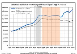
Development of Population since 1875 within the Current Boundaries (Blue Line: Population; Dotted Line: Comparison to Population Development of Brandenburg state; Grey background: Time of Nazi rule; Red background: Time of communist rule)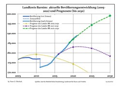
Recent Population Development and Projections (Population Development before Census 2011 (blue line); Recent Population Development according to the Census in Germany in 2011 (blue bordered line); Official projections for 2005-2030 (yellow line); for 2014-2030 (red line); for 2017-2030 (scarlet line)
Landkreis Barnim: Population development within the current boundaries (2019)[2]
| YearPop.±% p.a. 1875 74,305— 1890 85,169+0.91% 1910 106,837+1.14% 1925 115,955+0.55% 1933 133,005+1.73% 1939 154,918+2.57% 1946 154,627−0.03% 1950 159,481+0.78% 1964 153,249−0.28% 1971 155,650+0.22% 1981 156,734+0.07% 1985 156,658−0.01% 1989 153,978−0.43% 1990 150,687−2.14% 1991 148,751−1.28% | YearPop.±% p.a. 1992 148,750−0.00% 1993 149,143+0.26% 1994 150,060+0.61% 1995 151,783+1.15% 1996 154,698+1.92% 1997 159,689+3.23% 1998 163,937+2.66% 1999 167,914+2.43% 2000 170,288+1.41% 2001 171,490+0.71% 2002 172,382+0.52% 2003 173,951+0.91% 2004 175,861+1.10% 2005 176,693+0.47% 2006 177,396+0.40% | YearPop.±% p.a. 2007 177,589+0.11% 2008 177,644+0.03% 2009 176,904−0.42% 2010 176,848−0.03% 2011 172,572−2.42% 2012 173,193+0.36% 2013 173,754+0.32% 2014 174,981+0.71% 2015 177,411+1.39% 2016 179,365+1.10% 2017 180,864+0.84% 2018 182,760+1.05% 2019 185,244+1.36% 2020 187,343+1.13% |
|---|

District banner of Barnim
The coat of arms of the district resembles the coat of arms of the former district Oberbarnim. The only difference is that the old one had a silver top half and a red bottom half, while the current one is split into four parts and in the right half exchanged red and silver. The eagle in the top half is the eagle of Brandenburg.
Towns and municipalities
[edit]

Clickable map of towns and municipalities in the district
| Amt-free towns | Ämter | |
|---|---|---|
| Bernau bei Berlin Eberswalde Werneuchen Amt-free municipalities Ahrensfelde Panketal Schorfheide Wandlitz | 1. Amt Biesenthal-Barnim Biesenthal1, 2 Breydin Marienwerder Melchow Rüdnitz Sydower Fließ 2. Amt Britz-Chorin-Oderberg Britz1 Chorin Hohenfinow Liepe Lunow-Stolzenhagen Niederfinow Oderberg2 Parsteinsee | 3. Joachimsthal (Schorfheide) Althüttendorf Friedrichswalde Joachimsthal1, 2 Ziethen |
| 1seat of the Amt; 2town |
- ^ "Bevölkerungsstand im Land Brandenburg Dezember 2023] (Fortgeschriebene amtliche Einwohnerzahlen, basierend auf dem Zensus 2022)". Amt für Statistik Berlin-Brandenburg (in German).
- ^ Detailed data sources are to be found in the Wikimedia Commons.Population Projection Brandenburg at Wikimedia Commons
![]()
![]() Media related to Barnim at Wikimedia Commons
Media related to Barnim at Wikimedia Commons
- Official website (in German)