Beni, Myagdi (original) (raw)
Municipality in Gandaki Province, Nepal
| Beni Municipality बेनी नगरपालिकाBeni Bazaar | |
|---|---|
| Municipality | |
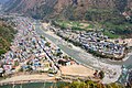
 Aerial view of the municipality in 2012 Aerial view of the municipality in 2012 |
|
| Motto: दुई खोलाको संगम | |
  Beni MunicipalityLocation in NepalShow map of Gandaki Province Beni MunicipalityLocation in NepalShow map of Gandaki Province Beni MunicipalityBeni Municipality (Nepal)Show map of Nepal Beni MunicipalityBeni Municipality (Nepal)Show map of Nepal |
|
| Coordinates: 28°21′0″N 83°34′0″E / 28.35000°N 83.56667°E / 28.35000; 83.56667 | |
| Country |  Nepal Nepal |
| Province | Gandaki Province |
| District | Myagdi District |
| Government | |
| • Mayor | Surat K.C. (CPNUML) |
| • Deputy Mayor | Jyoti Lmichhane (Nepal Communist Party Maoist Centre) |
| Area | |
| • Total | 52.77 km2 (20.37 sq mi) |
| Population (2011) | |
| • Total | 28,511 |
| • Density | 540/km2 (1,400/sq mi) |
| Time zone | UTC+5:45 (NST) |
| Postal code | 33200 |
| Area code | 069 |
| Website | http://benimun.gov.np/ |

Kali Gandaki River Bridge in Beni, Myagdi, Nepal
Beni is a municipality and the district headquarters of Myagdi District in Gandaki Province, Nepal. Municipality was announced by merging the then Ratnechaur, Jyamrukot, Arthunge, Pulachaur, Singa village development committees since 18 May 2014.[1]
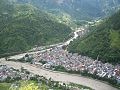
Beni is located at the confluence of the Kali Gandaki River and Myagdi River at an altitude of 899 meters. Being the northernmost of the Tri-cities area of Nepal, it is located 12 km to the north of Zonal headquarters Baglung. It is mainly divided into two parts by the Kali Gandaki River. The Western Part lies in Myagdi District and the main offices lie there. The other part lies in Parbat District and is relatively small.
At the time of the 2011 Nepal census, Beni Municipality had a population of 34,878. Of these, 92.9% spoke Nepali, 2.8% Magar, 1.9% Newar, 0.7% Chantyal, 0.3% Bhojpuri, 0.2% Gurung, 0.2% Hindi, 0.2% Maithili, 0.2% Thakali, 0.1% Kham, 0.1% Sanskrit, 0.1% Tamang and 0.1% other languages as their first language.[2]
In terms of ethnicity/caste, 29.0% were Chhetri, 21.7% Magar, 13.3% Hill Brahmin, 8.1% Damai/Dholi, 8.0% Kami, 6.3% Sarki, 3.8% Newar, 2.6% Thakuri, 2.2% Chhantyal, 1.1% Gurung, 1.0% Thakali, 0.6% Kisan, 0.4% Musalman, 0.4% Sanyasi/Dasnami, 0.2% Rai, 0.2% Tamang, 0.1% Badi, 0.1% Halwai, 0.1% Koiri/Kushwaha, 0.1% Teli, 0.1% other Terai, 0.1% Tharu and 0.4% others.[3]
In terms of religion, 92.2% were Hindu, 6.2% Buddhist, 1.0% Christian, 0.4% Muslim and 0.1% others.[4]
In terms of literacy, 77.2% could read and write, 2.3% could only read and 20.4% could neither read nor write.[5]
Beni meaning the place where two rivers meet was the winter headquarters of Parvat Rajya. It was on the Tibet-Nepal trading route before the invasion of Parvat Rajya.[6]
Beni municipality has many private, community as well as government schools. Some of them are as follows.
- Beni Community Higher Secondary School
- West point Higher Secondary School
- Beni Boarding Secondary School
- Prakash Higher Secondary School, Beni
- Little Garden Academy
- Shree Ramchandra Secondary School
- Mount Everest Secondary School
- Shree Galeshwor Higher Secondary School
- Dhawalagiri Secondary High School
- Shree Arjun Secondary School
- Bhanu Higher Secondary School
- Shree Paulastya Higher Secondary School
- Lokdeep Secondary Boarding School
- Rastriya Secondary School
- Shree Jayanti Secondary School
- Shree Musung Dhole Aadarbhut School
- Deep Shikha Higher Secondary School
- Jamunakharka Higher Secondary School
- Galeshwor Adarsha Secondary Boarding School
Although Beni is small but it is really beautiful. Some of the popular tourist destinations are:
- Kaligandaki Rafting
- Galeshwor Temple
- Lovely Hill
- Myagdi River Rafting
- Gateway of Mustang
- Beldhunga
- Todke View Point
- Singa Tatopani

Upstream of Galeshwor temple
Lord Vishnu in Galeshwor temple- 2004 Beni attack


- ^ Govt announces 72 new municipalities Archived 6 October 2014 at the Wayback Machine The Kathmandu Post
- ^ NepalMap Language [1]
- ^ NepalMap Caste [2]
- ^ NepalMap Religion [3]
- ^ NepalMap Literacy [4]
- ^ Location of Beni - Falling Rain Genomics