Geleen (original) (raw)
From Wikipedia, the free encyclopedia
City in Limburg, Netherlands
| Geleen | |
|---|---|
| City | |
 The Krawinkel neighbourhood The Krawinkel neighbourhood |
|
 Flag Flag Coat of arms Coat of arms |
|
  GeleenLocation in the NetherlandsShow map of Netherlands GeleenLocation in the NetherlandsShow map of Netherlands GeleenLocation in the province of Limburg in the NetherlandsShow map of Limburg, Netherlands GeleenLocation in the province of Limburg in the NetherlandsShow map of Limburg, Netherlands |
|
| Coordinates: 50°58′N 5°50′E / 50.967°N 5.833°E / 50.967; 5.833 | |
| Country | Netherlands |
| Province | Limburg |
| Municipality | Sittard-Geleen |
| Area[1] | |
| • Total | 19.64 km2 (7.58 sq mi) |
| Elevation[2] | 32 m (105 ft) |
| Population (2021)[1] | |
| • Total | 31,245 |
| • Density | 1,591/km2 (4,120/sq mi) |
| Time zone | UTC+1 (CET) |
| • Summer (DST) | UTC+2 (CEST) |
| Postal code | 6160-6167[1] |
| Dialing code | 046 |
| Major roads | A76, A2, N276, N294 |
Geleen (Dutch pronunciation: [ɣəˈleːn]; Limburgish: Gelaen [ɣəˈlɛːn]) is a city in the southern part of the province of Limburg in the Netherlands. With 31,670 inhabitants in 2020, it is part of the municipality of Sittard-Geleen. Geleen is situated along the river Geleenbeek, a right tributary to the river Meuse. The Latin name for Geleenbeek is Glana, meaning "clear river". The town centre is situated at about 60 m above sea level.
Until the end of the 19th century, Geleen was a very small village. Its population was 2,545 in 1899.[3] The remains of one of the oldest prehistoric farms in the Netherlands were found here. In the 20th century the exploitation of coal mines in this area (the state-owned coal mine "Maurits", the biggest in Europe, was located in Geleen) brought a fast population increase. During the 1960s and 1970s the Dutch coal mines, which were all located in this part of the province, were closed. The state mining company DSM (privatised in 1989) remained active in Geleen, however, now purely as a chemicals producer. In July 2002, part of DSM's petrochemicals business, located on the manufacturing locations in Geleen and Gelsenkirchen (Germany) were acquired by SABIC Europe.
- The soccer club Fortuna '54, was the former soccer club of Geleen.
- Geleen has a professional ice hockey team called the Geleen Eaters.
- The handball club Vlug en Lenig is from Geleen.
- The pop and rock festival Pinkpop, the oldest and longest running annual dedicated pop and rock music festival in the world,[4][5] also has its roots in Geleen. It was held there from 1970 until 1986. This festival was held in the Burgemeester Damen Sportpark, which includes the sports centre Glanerbrook. The nearby swimming pool was popular with the artists, who enjoyed themselves backstage.
- In Geleen there's a yearly town fair (one week after Whitsun).
- Stage 5 of Eneco Tour of Benelux a road bicycle racing and part of the UCI ProTour finished in Geleen on August 16, 2013.

Sint-Janskluis from 1699
- Ruins of Jansgeleen Castle, with restored outer bailey and water mill (Sint-)Jansmolen, to the south-east of Geleen, on the territory of the municipality of Beek.
- Sint-Janskluis, former hermitage from 1699.
- De Biesenhof, recently restored historical farmhouse.
- Parish church Sint Marcellinus and Petrus of Oud-Geleen.
- Drossaerdhuis at Geenstraat.
- Monument at Geenstraat (near train station Geleen-Lutterade) in memory of the martyr sister Aloysia, the Jewish-Catholic Louise Löwenfels.[6]
- Main building of Staatsmijn Maurits.
- Restored former brickyard Plinthos, the present office of park De Graven, at Daniken (near train station Geleen-Oost).
- Foroxity cinema: the largest cinema in Limburg.
- Zuyderland Medical Centrum: a fairly recent hospital with modern architecture.
- Burgemeester Damen Sportpark, the location of the Pinkpop Festival from 1970 to 1986.

Topographic map of Geleen, March 2014
Geleen is served by two railway stations: Geleen-Lutterade, on the line Sittard-Maastricht, and Geleen Oost, on the line Sittard-Heerlen.
Geleen is also served by two motorways: A2 Amsterdam-Maastricht, exit Urmond, and A76 Antwerp-Aachen, exit Geleen.
- Jasper Adams (born 1989), Dutch handball player
- Benjamin van den Broek (born 1987), Dutch-born New Zealand footballer
- Charles of Mount Argus (1821–1893), Dutch Passionist priest and Saint
- Rick Geenen (born 1988), Dutch footballer
- Myrthe Hilkens (born 1979), Dutch journalist, non-fiction writer and politician
- Wil Jacobs (born 1960), Dutch handball player
- Pierre Kerkhoffs (1936–2021), Dutch footballer
- Paul Kusters (born 1966), Dutch cartoonist
- Paul van Loon (born 1955), Dutch children's author
- Dominick Muermans (born 1984), Dutch racing driver
- Jean Nelissen (1936–2010), Dutch sports journalist
- Maartje Paumen (born 1985), Dutch field hockey player
- Gabriëlle Popken (born 1983), Dutch politician
- Roel Rothkrans (born 1979), Dutch handball player
- Ton Raven (born 1957), Dutch politician
- Pim Rietbroek (born 1942), Dutch handball player and coach
- René Shuman (born 1967), Dutch singer
- Inger Smits (born 1994), Dutch handball player
- Jorn Smits (born 1992), Dutch handball player
- Kay Smits (born 1997), Dutch handball player
- Henk Steevens (1931–2020), Dutch cyclist

Geleen market
Marcelienstraat in Geleen
Marcellinus en Petruskerk in Oud-Geleen
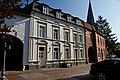
Huis Maes in Geleen
Huis Corten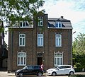
House in Geleen- [
![Huis ten Dijcken [nl]](http://upload.wikimedia.org/wikipedia/commons/thumb/2/2f/Huis_ten_Dijcken_vanaf_vijver.jpg/120px-Huis_ten_Dijcken_vanaf_vijver.jpg) ](/wiki/File:Huis%5Ften%5FDijcken%5Fvanaf%5Fvijver.jpg "Huis ten Dijcken [nl]")
](/wiki/File:Huis%5Ften%5FDijcken%5Fvanaf%5Fvijver.jpg "Huis ten Dijcken [nl]") - [
![Kasteel Terborgh [nl]](http://upload.wikimedia.org/wikipedia/commons/thumb/0/00/Terborch.JPG/120px-Terborch.JPG) ](/wiki/File:Terborch.JPG "Kasteel Terborgh [nl]")
](/wiki/File:Terborch.JPG "Kasteel Terborgh [nl]") 
Sculpture De Sjöt


- ^ a b c "Kerncijfers wijken en buurten 2021". Central Bureau of Statistics. Retrieved 25 April 2022.
- ^ "Postcodetool for 6061AA". Actueel Hoogtebestand Nederland (in Dutch). Het Waterschapshuis. 24 July 2019. Archived from the original on 21 September 2013. Retrieved 25 April 2022.
- ^ "Volkstelling 1899: Limburg" (XLS).
- ^ Gammon, John (17 June 2011). "Six In A Row For Pinkpop". London, U.K.: Pollstar. Archived from the original on 13 August 2014. Retrieved 13 August 2014.
- ^ "Pinkpop is langstlopende popfestival ter wereld" [Pinkpop is longest running pop festival in the world]. geschiedenis.vpro.nl/ (in Dutch). VPRO independent Dutch public broadcaster. 18 May 2010. Retrieved 13 August 2014.
- ^ "About Luise Löwenfels". Joods Monument. Retrieved 18 May 2021.
![]()
Wikimedia Commons has media related to Geleen.
 Geleen travel guide from Wikivoyage
- Official website of Sittard-Geleen