Kasganj district (original) (raw)
From Wikipedia, the free encyclopedia
District of Uttar Pradesh in India
| Kasganj district | |
|---|---|
| District of Uttar Pradesh | |
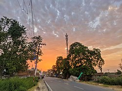
 Sunset in Bilram Sunset in Bilram |
|
 |
|
| Coordinates: 27°49′N 78°39′E / 27.82°N 78.65°E / 27.82; 78.65 | |
| Country |  India India |
| State | Uttar Pradesh |
| Division | Aligarh |
| Headquarters | Kasganj |
| Area | |
| • Total | 1,993 km2 (770 sq mi) |
| Population (2011) | |
| • Total | 1,436,719 |
| • Density | 720/km2 (1,900/sq mi) |
| Languages | |
| • Official | Hindi |
| Time zone | UTC+5:30 (IST) |
| ISO 3166 code | IN-UP-KN |
| Literacy | 62.3% |
| Website | https://kasganj.nic.in/ |
Kasganj district (earlier called Kanshiram Nagar) is a district of the Indian state Uttar Pradesh. It is located in the division of Aligarh and consists of Kasganj, Patiali and Sahawar tehsils. Its headquarters is at Kasganj.[1]
The district lies in the cultural region of Braj. Kasganj was established on 17 April 2008 by separating Kasganj, Patiali and Sahawar tehsils from Etah district. For a while, the district was named after a politician, Kanshi Ram. The decision taken by Mayawati, chief minister of Uttar Pradesh and president of the BSP provoked protests by lawyers who had proposed to call it in honor of Sant Sant Tulsidas, who was born in the district, that place known as Soron (Sukarkshetra).[2] The district reverted to its original name in 2012.[3] Adjacent districts of Kasganj are Aligarh, Budaun, Etah, Farrukhabad and Atrauli Tehsil.
Historical population
| Year | Pop. | ±% p.a. |
|---|---|---|
| 1901 | 386,383 | — |
| 1911 | 389,747 | +0.09% |
| 1921 | 371,135 | −0.49% |
| 1931 | 384,897 | +0.36% |
| 1941 | 440,490 | +1.36% |
| 1951 | 502,930 | +1.33% |
| 1961 | 588,879 | +1.59% |
| 1971 | 699,806 | +1.74% |
| 1981 | 826,616 | +1.68% |
| 1991 | 991,289 | +1.83% |
| 2001 | 1,228,705 | +2.17% |
| 2011 | 1,436,719 | +1.58% |
| source:[4] |
| Religions in Kasganj district (2011)[5] | |
|---|---|
| Religion | Percent |
| Hinduism | 84.32% |
| Islam | 14.88% |
| Other or not stated | 0.80% |
| Distribution of religions |
According to the 2011 census Kasganj district has a population of 1,436,719,[6] roughly equal to the nation of Eswatini[7] or the US state of Hawaii.[8] This gives it a ranking of 345th in India (out of a total of 640).[6] The district has a population density of 736 inhabitants per square kilometre (1,910/sq mi).[6] Its population growth rate over the decade 2001–2011 was 17.05%.[6] Kasganj has a sex ratio of 879 females for every 1,000 males,[6] and a literacy rate of 62.3%. 20.06% of the population lived in urban areas. Scheduled Castes make up 17.70% of the population.[6]
Languages of Kasganj district (2011)[9]
At the time of the 2011 Census of India, 91.45% of the population in the district spoke Hindi and 8.27% Urdu as their first language.[9] The local languages are Brajbhasha and Kannauji.
- ^ "Kanshiram Nagar to be State's 71st district". Archived from the original on 13 May 2009. Retrieved 20 May 2015.
- ^ "Lawyers against naming new Kasganj district after Kanshi Ram". Archived from the original on 5 March 2016. Retrieved 20 May 2015.
- ^ "Important Cabinet Decisions". Lucknow: Information and Public Relations Department. Archived from the original on 24 October 2014. Retrieved 17 January 2013.
- ^ Decadal Variation In Population Since 1901
- ^ "Table C-01 Population by Religion: Uttar Pradesh". censusindia.gov.in. Registrar General and Census Commissioner of India. 2011.
- ^ a b c d e f "District Census Handbook: Kasganj" (PDF). censusindia.gov.in. Registrar General and Census Commissioner of India. 2011.
- ^ US Directorate of Intelligence. "Country Comparison:Population". Archived from the original on 13 June 2007. Retrieved 1 October 2011. Swaziland 1,370,424
- ^ "2010 Resident Population Data". U. S. Census Bureau. Archived from the original on 1 January 2011. Retrieved 30 September 2011. Hawaii 1,360,301
- ^ a b "Table C-16 Population by Mother Tongue: Uttar Pradesh". www.censusindia.gov.in. Registrar General and Census Commissioner of India.