Kurosaki Station (original) (raw)
Railway station in Kitakyushu, Japan
| JA 21 Kurosaki黒崎 | |
|---|---|
 Panorama of Kurosaki Station Panorama of Kurosaki Station |
|
| General information | |
| Location | Yahatanishi Ward, Kitakyushu CityFukuoka PrefectureJapan |
| Operated by |  JR Kyushu Chikuhō Electric Railroad JR Kyushu Chikuhō Electric Railroad |
| Line(s) | JA Kagoshima Main Line Fukuhoku Yutaka Line Chikuhō Electric Railroad Line |
| Connections |  Bus stop Bus stop |
| Other information | |
| Station code | CK01 (Chikuhō)JA21 (Kagashima Line) |
| History | |
| Opened | 28 February 1891; 133 years ago (1891-02-28) |
Location  JA 21 KurosakiLocation within Fukuoka PrefectureShow map of Fukuoka Prefecture JA 21 KurosakiLocation within Fukuoka PrefectureShow map of Fukuoka Prefecture  JA 21 KurosakiJA 21 Kurosaki (Kyushu)Show map of Kyushu JA 21 KurosakiJA 21 Kurosaki (Kyushu)Show map of Kyushu  JA 21 KurosakiJA 21 Kurosaki (Japan)Show map of Japan JA 21 KurosakiJA 21 Kurosaki (Japan)Show map of Japan |
Kurosaki Station (黒崎駅) is a railway station in Yahatanishi-ku, Kitakyushu serving Kagoshima Main Line, Fukuhoku Yutaka Line and Chikuhō Electric Railroad Line. It was first opened in 1891.[1] Express trains, including the Sonic, stop here.
JR limited express trains
[edit]
- Sonic (Hakata - Yanagigaura/Ōita/Saiki)
- Nichirin Seagaia (Hakata - Miyazaki Kūkō)
- Kirameki (Mojikō/Kokura - Hakata)
| JA 21 Kurosaki Station黒崎駅 | |
|---|---|
 JR Kyūshū Kurosaki entrance JR Kyūshū Kurosaki entrance |
|
| General information | |
| Location | 3 Chome-15-1 Kurosaki, Yahatanishi Ward, Kitakyushu City, Fukuoka PrefectureJapan |
| Operated by |  JR Kyushu JR Kyushu |
| Line(s) | JA Kagoshima Main Line Fukuhoku Yutaka Line |
| Platforms | 2 island platforms |
| Tracks | 4 |
| Connections |  Bus terminal Bus terminal |
| Construction | |
| Structure type | At grade |
| Other information | |
| Station code | JA21 |
| History | |
| Opened | 28 February 1891; 133 years ago (1891-02-28) |
| Passengers | |
| 2017 | 15,394 daily |
| Services | |
Preceding station  JR Kyushu Following station JinnoharuJA 20 towards Kagoshima Kagoshima Main LineLocal YahataJA 22 towards Mojikō OrioJA 19 towards Kagoshima Kagoshima Main LineSemi-Rapid Rapid Limited Express JR Kyushu Following station JinnoharuJA 20 towards Kagoshima Kagoshima Main LineLocal YahataJA 22 towards Mojikō OrioJA 19 towards Kagoshima Kagoshima Main LineSemi-Rapid Rapid Limited Express |
|
JR Kurosaki Station is the station serving the Kagoshima Main Line and is the terminus of Fukuhoku Yutaka Line. The station consist of 2 islands serving four tracks and handles an average of 15,000 passengers a day. At the south exit of the station there is a pedway that also serves as a station square, connecting the Izutsuya department store on the east side with the commercial area on the south side.
| 1 | ■ Limited Express Sonic, Nichirin Seagaia | for Kashii and Hakata |
|---|---|---|
| ■ Limited Express Kirameki | for Hakata | |
| ■ Kagoshima Main Line | for Kashii, Hakata and Ōmuta | |
| ■ Fukuhoku Yutaka Line | for Nōgata, Iizuka and Hakata | |
| 2 | ■ Limited Express Sonic, Nichirin Seagaia | for Oita, Miyazaki, and Miyazaki Kūkō |
| ■ Limited Express Kirameki | for Kokura and Mojikō | |
| ■ Kagoshima Main Line | for Kokura and Mojikō | |
| 3 | ■ Fukuhoku Yutaka Line | for Nōgata and Iizuka (Used for first departures) |
| 4 | ■ Kagoshima Main Line | for Kokura and Mojikō (Used for through service from Fukuhoku Yutaka Line)|} |
| ← | Service | → |
|---|---|---|
| Kyushu Railway Company | ||
| Fukuhoku Yutaka Line | ||
| - | Local | JA 20 Jinnoharu |
| - | Rapid | JA 20 Jinnoharu |
Chikuhō Electric Railroad
[edit]
| Kurosaki-Ekimae Station黒崎駅前駅 | |
|---|---|
| Chikuhō Electric Railroad station | |
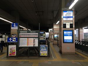
 Kurosaki-Ekimae Station platform Kurosaki-Ekimae Station platform |
|
| General information | |
| Location | 3 Chome-15-1 Kurosaki, Yahatanishi, Kitakyushu, FukuokaJapan |
| Operated by | Chikuhō Electric Railroad |
| Line(s) | Chikuhō Electric Railroad Line |
| Platforms | 2 side platform, 1 island platform |
| Connections | Bus terminal |
| Other information | |
| Station code | CK 01 |
| History | |
| Opened | 1911 |
| Passengers | |
| 2013 | 8,850 daily |
Kurosaki-Ekimae Station is the terminus of Chikuhō Electric Railroad Line opened on 15 July 1911. The station consist of 3 platforms serving two tracks and handles an average of 8,000 passengers a day.
| ← | Service | → |
|---|---|---|
| Chikuhō Electric Railroad Line | ||
| Terminus | Local | Nishi-Kurosaki |
- ^ Ishino 1998, pp. 675–676.
- Ishino, Tetsu; et al., eds. (1998). 停車場変遷大事典 国鉄・JR編 [_Station Transition Directory – JNR/JR_] (in Japanese). Vol. II. Tokyo: JTB Corporation. ISBN 4-533-02980-9.
33°52′01″N 130°45′58″E / 33.8668433°N 130.7661438°E / 33.8668433; 130.7661438