Münsing (original) (raw)
From Wikipedia, the free encyclopedia
Municipality in Bavaria, Germany
| Münsing | |
|---|---|
| Municipality | |
 Church of the Assumption of the Virgin Mary Church of the Assumption of the Virgin Mary |
|
 Coat of arms Coat of arms |
|
Location of Münsing within Bad Tölz-Wolfratshausen district 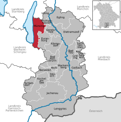 |
|
  Münsing Show map of Germany Münsing Show map of Germany Münsing Show map of Bavaria Münsing Show map of Bavaria |
|
| Coordinates: 47°54′N 11°22′E / 47.900°N 11.367°E / 47.900; 11.367 | |
| Country | Germany |
| State | Bavaria |
| Admin. region | Oberbayern |
| District | Bad Tölz-Wolfratshausen |
| Government | |
| • Mayor (2020–26) | Michael Grasl[1] (FW) |
| Area | |
| • Total | 52.20 km2 (20.15 sq mi) |
| Elevation | 666 m (2,185 ft) |
| Population (2023-12-31)[2] | |
| • Total | 4,397 |
| • Density | 84/km2 (220/sq mi) |
| Time zone | UTC+01:00 (CET) |
| • Summer (DST) | UTC+02:00 (CEST) |
| Postal codes | 82541 |
| Dialling codes | 08177 |
| Vehicle registration | TÖL, WOR |
| Website | www.muensing.de |
Münsing is a municipality in the district of Bad Tölz-Wolfratshausen in Bavaria in Germany.
Located in the Upper Bavarian district of Bad Tölz-Wolfratshausen, it borders Lake Starnberg to its west. Its municipal area extends from the shores of Lake Starnberg to the Münsinger Rücken, a ridge which rises between the lake and the Isar valley, and also includes the western Tischberg, which forms its southern crest. The eponymous village Münsing, is the seat of the municipal administration, which also contains the villages of Degerndorf, Ammerland, Ambach, Holzhausen am Starnberger See, and St. Heinrich.[3]
- ^ Liste der ersten Bürgermeister/Oberbürgermeister in kreisangehörigen Gemeinden, Bayerisches Landesamt für Statistik, accessed 19 July 2021.
- ^ Genesis Online-Datenbank des Bayerischen Landesamtes für Statistik Tabelle 12411-003r Fortschreibung des Bevölkerungsstandes: Gemeinden, Stichtag (Einwohnerzahlen auf Grundlage des Zensus 2011).
- ^ "Bayerische Landesbibliothek Online (BLO)".