Magdalena, Jalisco (original) (raw)
From Wikipedia, the free encyclopedia
Municipality and town in Jalisco, Mexico
| Magdalena | |
|---|---|
| Municipality and town | |
 Coat of arms Coat of arms |
|
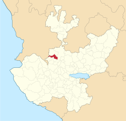
 Location of the municipality in Jalisco Location of the municipality in Jalisco |
|
  MagdalenaLocation in Mexico MagdalenaLocation in Mexico |
|
| Coordinates: 20°55′N 103°57′W / 20.917°N 103.950°W / 20.917; -103.950 | |
| Country |  Mexico Mexico |
| State | Jalisco |
| Area | |
| • Total | 293.2 km2 (113.2 sq mi) |
| • Town | 4.35 km2 (1.68 sq mi) |
| Population (2020 census)[1] | |
| • Total | 21,781 |
| • Density | 74/km2 (190/sq mi) |
| • Town | 16,873 |
| • Town density | 3,900/km2 (10,000/sq mi) |
| Time zone | UTC-6 (Central Standard Time) |
| • Summer (DST) | UTC-5 (Central Daylight Time) |
Magdalena is a town and municipality in the state of Jalisco in central-western Mexico. Magdalena lies 78 kilometers northwest of Guadalajara. The municipality covers an area of 293.2 km2. It borders the state of Nayarit to the west, and the town of Tequila to the east. As of 2005, the municipality had a total population of 18,924.[2]
The town is situated on rather high 1350 meters above sea level. It borders mountains to the north and somehow smaller hills to the south.
In the west, there is a big water reservoir called the Laguna de Magdalena, which features many different birds.[3][4]
| Climate data for Magdalena, Jalisco (1991–2020 normals, extremes 1955–present) | |||||||||||||
|---|---|---|---|---|---|---|---|---|---|---|---|---|---|
| Month | Jan | Feb | Mar | Apr | May | Jun | Jul | Aug | Sep | Oct | Nov | Dec | Year |
| Record high °C (°F) | 38(100) | 37(99) | 39(102) | 40.2(104.4) | 41(106) | 45(113) | 38(100) | 39(102) | 39.5(103.1) | 38(100) | 37.5(99.5) | 36.5(97.7) | 45(113) |
| Mean daily maximum °C (°F) | 26.0(78.8) | 28.0(82.4) | 30.4(86.7) | 32.6(90.7) | 34.0(93.2) | 33.0(91.4) | 30.1(86.2) | 29.5(85.1) | 29.1(84.4) | 28.9(84.0) | 27.8(82.0) | 26.4(79.5) | 29.6(85.3) |
| Daily mean °C (°F) | 16.3(61.3) | 18.0(64.4) | 19.7(67.5) | 21.8(71.2) | 23.6(74.5) | 24.8(76.6) | 23.4(74.1) | 23.1(73.6) | 22.9(73.2) | 21.7(71.1) | 19.0(66.2) | 16.7(62.1) | 20.9(69.6) |
| Mean daily minimum °C (°F) | 6.6(43.9) | 7.9(46.2) | 9.0(48.2) | 10.9(51.6) | 13.3(55.9) | 16.6(61.9) | 16.7(62.1) | 16.8(62.2) | 16.6(61.9) | 14.5(58.1) | 10.3(50.5) | 7.1(44.8) | 12.2(54.0) |
| Record low °C (°F) | 0(32) | 0.5(32.9) | 0(32) | 0(32) | 5(41) | 8(46) | 10(50) | 10.5(50.9) | 7(45) | 3(37) | 1(34) | −1(30) | −1(30) |
| Average precipitation mm (inches) | 27.4(1.08) | 12.6(0.50) | 7.8(0.31) | 2.6(0.10) | 19.6(0.77) | 159.9(6.30) | 253.1(9.96) | 248.4(9.78) | 173.3(6.82) | 54.7(2.15) | 13.6(0.54) | 14.6(0.57) | 987.6(38.88) |
| Average precipitation days | 2.2 | 1.4 | 0.7 | 0.6 | 2.0 | 11.1 | 17.7 | 17.2 | 13.1 | 4.9 | 1.6 | 1.7 | 74.2 |
| Source: Servicio Meteorológico Nacional[5][6] |
Magdalena is famous for fire opals; the whole region accommodates hundreds of mines where Obsidian, Fire opals, and other rocks are produced.[7] In the town, there are several stores selling stones.
- ^ Citypopulation.de Population of Magdalena municipality with localities
- ^ Enciclopedia de los Municipios de México, Instituto Nacional para el Federalismo y el Desarrollo Municipal, April 16, 2009.
- ^ "Magdalena | Gobierno del Estado de Jalisco". www.jalisco.gob.mx. Retrieved 2020-07-29.
- ^ "Avalan importancia arqueológica de exlaguna de Magdalena". www.milenio.com. Retrieved 2020-07-29.
- ^ "NORMAL CLIMATOLÓGICA 1991-2020" (TXT). Servicio Meteorológico Nacional. Archived from the original on 5 January 2025. Retrieved 5 January 2025.
- ^ "VALORES EXTREMOS" (TXT). Servicio Meteorológico Nacional. Archived from the original on 5 January 2025. Retrieved 5 January 2025.
- ^ "World Class Fire Opals Mined Near Puerto Vallarta". BanderasNews.
- Chess Club Magdalena Jalisco
- Xochiltepec-Monte cubiero de flores - (Xochiltepec - The old name of Magdalena Jalisco)