Maria, Siquijor (original) (raw)
From Wikipedia, the free encyclopedia
Municipality in Siquijor, Philippines
Municipality in Negros Island Region, Philippines
| Maria | |
|---|---|
| Municipality | |
| Municipality of Maria | |
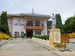
 Maria Town Hall Maria Town Hall |
|
 Flag Flag |
|
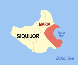
 Map of Siquijor with Maria highlighted Map of Siquijor with Maria highlighted |
|
OpenStreetMap |
|
  MariaLocation within the Philippines MariaLocation within the Philippines |
|
| Coordinates: 9°11′46″N 123°39′18″E / 9.196°N 123.655°E / 9.196; 123.655 | |
| Country | Philippines |
| Region | Negros Island Region |
| Province | Siquijor |
| District | Lone district |
| Barangays | 22 (see Barangays) |
| Government [1] | |
| • Type | Sangguniang Bayan |
| • Mayor | Roselyn T. Asok (PFP) |
| • Vice Mayor | Meynard R. Asok (PFP) |
| • Representative | Zaldy Villa (Lakas) |
| • Municipal Council | Members Ronald Guy B. MagpiongCandelaria A. AninipoMeinrad Mark M. MagsayoMaribeth D. AdlaoChuser C. SamsonRivian L. PerezJose M. Maglangit, Jr.Rosally U. Gabas |
| • Electorate | 11,532 voters (2025) |
| Area[2] | |
| • Total | 53.37 km2 (20.61 sq mi) |
| Elevation | 23.8 m (78 ft) |
| Highest elevation | 448 m (1,470 ft) |
| Lowest elevation | 0 m (0 ft) |
| Population (2024 census) | |
| • Total | 15,146 |
| • Density | 283.8/km2 (735.0/sq mi) |
| • Households | 3,545 |
| Economy | |
| • Income class | 4th municipal income class |
| • Poverty incidence | 9.57% (2021) |
| • Revenue | ₱ 113 million (2022) |
| • Assets | ₱ 122.2 million (2022) |
| • Expenditure | ₱ 92.85 million (2022) |
| • Liabilities | ₱ 27.17 million (2022) |
| Service provider | |
| • Electricity | Province of Siquijor Electric Cooperative (PROSIELCO) |
| Time zone | UTC+8 (PST) |
| ZIP code | 6229 |
| PSGC | 076104000 |
| IDD : area code | +63 (0)35 |
| Native languages | Cebuano Tagalog |
| Patron saint | Our Lady of Divine Providence |
Maria, officially the Municipality of Maria (Cebuano: Lungsod sa Maria; Tagalog: Bayan ng Maria), is a municipality in the province of Siquijor, Philippines. According to the 2020 census, it has a population of 14,385.
The name change from the previous local name, Kangmenia, was made by Spanish friars in 1880 to honor Mary, mother of Jesus. Maria is 32 kilometres (20 mi) from the provincial capital Siquijor.
The man-made Salagdoong Forest
Maria is politically subdivided into 22 barangays. Each barangay consists of puroks and some have sitios.
| PSGC | Barangay | Population | ±% p.a. | |||
|---|---|---|---|---|---|---|
| 2024[3] | 2010[4] | |||||
| 076104001 | Bogo | 5.6% | 851 | 739 | ▴ | 0.98% |
| 076104002 | Bonga | 3.7% | 555 | 459 | ▴ | 1.32% |
| 076104003 | Cabal‑asan | 2.6% | 389 | 357 | ▴ | 0.60% |
| 076104004 | Calunasan | 4.2% | 643 | 641 | ▴ | 0.02% |
| 076104005 | Candaping A | 3.8% | 582 | 448 | ▴ | 1.83% |
| 076104006 | Candaping B | 4.5% | 684 | 591 | ▴ | 1.02% |
| 076104007 | Cantaroc A | 3.1% | 462 | 385 | ▴ | 1.27% |
| 076104008 | Cantaroc B | 3.3% | 501 | 411 | ▴ | 1.38% |
| 076104009 | Cantugbas | 2.7% | 412 | 400 | ▴ | 0.20% |
| 076104010 | Lico‑an | 3.3% | 496 | 529 | ▾ | −0.44% |
| 076104011 | Lilo‑an | 9.6% | 1,459 | 1,470 | ▾ | −0.05% |
| 076104013 | Logucan | 4.3% | 647 | 557 | ▴ | 1.04% |
| 076104012 | Looc | 3.2% | 489 | 528 | ▾ | −0.53% |
| 076104014 | Minalulan | 5.6% | 843 | 703 | ▴ | 1.26% |
| 076104015 | Nabutay | 6.6% | 1,000 | 718 | ▴ | 2.32% |
| 076104016 | Olang | 4.6% | 701 | 592 | ▴ | 1.18% |
| 076104017 | Pisong A | 2.4% | 366 | 292 | ▴ | 1.57% |
| 076104018 | Pisong B | 1.6% | 249 | 293 | ▾ | −1.12% |
| 076104019 | Poblacion Norte | 7.6% | 1,153 | 1,170 | ▾ | −0.10% |
| 076104020 | Poblacion Sur | 4.3% | 656 | 675 | ▾ | −0.20% |
| 076104021 | Saguing | 5.3% | 803 | 946 | ▾ | −1.13% |
| 076104022 | Sawang | 2.9% | 444 | 479 | ▾ | −0.52% |
| Total | 15,146 | 13,383 | ▴ | 0.86% |
| Climate data for Maria, Siquijor | |||||||||||||
|---|---|---|---|---|---|---|---|---|---|---|---|---|---|
| Month | Jan | Feb | Mar | Apr | May | Jun | Jul | Aug | Sep | Oct | Nov | Dec | Year |
| Mean daily maximum °C (°F) | 29(84) | 30(86) | 31(88) | 32(90) | 31(88) | 30(86) | 30(86) | 30(86) | 30(86) | 29(84) | 29(84) | 29(84) | 30(86) |
| Mean daily minimum °C (°F) | 22(72) | 22(72) | 22(72) | 23(73) | 24(75) | 24(75) | 24(75) | 24(75) | 24(75) | 24(75) | 23(73) | 23(73) | 23(74) |
| Average precipitation mm (inches) | 26(1.0) | 22(0.9) | 28(1.1) | 41(1.6) | 95(3.7) | 136(5.4) | 147(5.8) | 126(5.0) | 132(5.2) | 150(5.9) | 98(3.9) | 46(1.8) | 1,047(41.3) |
| Average rainy days | 7.5 | 6.7 | 8.9 | 10.4 | 21.6 | 25.6 | 26.3 | 25.0 | 24.1 | 26.2 | 19.2 | 12.1 | 213.6 |
| Source: Meteoblue[5] |
Population census of Maria
| Year | Pop. | ±% p.a. |
|---|---|---|
| 1903 | 6,499 | — |
| 1918 | 8,477 | +1.79% |
| 1939 | 8,722 | +0.14% |
| 1948 | 8,547 | −0.22% |
| 1960 | 9,335 | +0.74% |
| 1970 | 9,942 | +0.63% |
| 1975 | 10,778 | +1.63% |
| 1980 | 10,951 | +0.32% |
| 1990 | 11,140 | +0.17% |
| 1995 | 11,106 | −0.06% |
| 2000 | 12,275 | +2.17% |
| 2007 | 12,974 | +0.77% |
| 2010 | 13,383 | +1.14% |
| 2015 | 13,828 | +0.62% |
| 2020 | 14,385 | +0.83% |
| 2024 | 15,146 | +1.25% |
| Source: Philippine Statistics Authority[6][4][7][8] |
Salagdoong Beach
Poverty incidence of Maria
The public schools in the town of Maria are administered by one school district under the Schools Division of Siquijor.
Elementary schools:
- Bogo Elementary School — Bogo
- Candaping Elementary School — Candaping B
- Cantaroc Elementary School — Cantaroc B
- Cantugbas Elementary School — Cantugbas
- Lico-an Elementary School — Lico-an
- Lilo-an Elementary School — Lilo-an
- Logucan Elementary School — Logucan
- Minalulan Elementary School — Minalulan
- Nabutay Elementary School — Nabutay
- Pisong A Elementary School — Pisong A
- Pisong B Elementary School — Pisong B
High schools:
- Candaping National High School — Candaping B
Integrated schools:
- Maria Integrated School (formerly Maria CS) — Poblacion Norte
- ^ Municipality of Maria | (DILG)
- ^ "2015 Census of Population, Report No. 3 – Population, Land Area, and Population Density" (PDF). Philippine Statistics Authority. Quezon City, Philippines. August 2016. ISSN 0117-1453. Archived (PDF) from the original on May 25, 2021. Retrieved July 16, 2021.
- ^ Census of Population (2020). "Region VII (Central Visayas)". Total Population by Province, City, Municipality and Barangay. Philippine Statistics Authority. Retrieved 8 July 2021.
- ^ a b Census of Population and Housing (2010). "Region VII (Central Visayas)" (PDF). Total Population by Province, City, Municipality and Barangay. National Statistics Office. Retrieved 29 June 2016.
- ^ "Maria: Average Temperatures and Rainfall". Meteoblue. Retrieved 28 April 2020.
- ^ Census of Population (2015). "Region VII (Central Visayas)". Total Population by Province, City, Municipality and Barangay. Philippine Statistics Authority. Retrieved 20 June 2016.
- ^ Censuses of Population (1903–2007). "Region VII (Central Visayas)". Table 1. Population Enumerated in Various Censuses by Province/Highly Urbanized City: 1903 to 2007. National Statistics Office.
- ^ "Province of Siquijor". Municipality Population Data. Local Water Utilities Administration Research Division. Retrieved 17 December 2016.
- ^ "Poverty incidence (PI):". Philippine Statistics Authority. Retrieved December 28, 2020.
- ^
- ^
- ^
- ^
- ^
- ^
- ^
Wikimedia Commons has media related to Maria.


