Mertingen (original) (raw)
From Wikipedia, the free encyclopedia
Municipality in Bavaria, Germany
| Mertingen | |
|---|---|
| Municipality | |
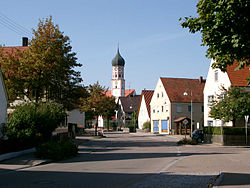
 Center of Mertingen Center of Mertingen |
|
 Coat of arms Coat of arms |
|
Location of Mertingen within Donau-Ries district  |
|
  Mertingen Show map of Germany Mertingen Show map of Germany  Mertingen Show map of Bavaria Mertingen Show map of Bavaria |
|
| Coordinates: 48°39′N 10°47′E / 48.650°N 10.783°E / 48.650; 10.783 | |
| Country | Germany |
| State | Bavaria |
| Admin. region | Schwaben |
| District | Donau-Ries |
| Government | |
| • Mayor (2020–26) | Veit Meggle[1] |
| Area | |
| • Total | 38.42 km2 (14.83 sq mi) |
| Elevation | 411 m (1,348 ft) |
| Population (2023-12-31)[2] | |
| • Total | 4,078 |
| • Density | 110/km2 (270/sq mi) |
| Time zone | UTC+01:00 (CET) |
| • Summer (DST) | UTC+02:00 (CEST) |
| Postal codes | 86690 |
| Dialling codes | 09078 |
| Vehicle registration | DON |
| Website | www.mertingen.de |
Mertingen is a municipality in the district of Donau-Ries in Bavaria in Germany.
The important Roman road, the Via Claudia Augusta was built in this area near the location of "Burghoefe" during the 1st century AD, linking Italy with the Danube river. It had its northern end around Mertingen, it then branched into a Roman military road following the Danube river from its origin in the West to Regensburg in the East.
The Zott dairy company has its headquarters and factory in the town.
- ^ Liste der ersten Bürgermeister/Oberbürgermeister in kreisangehörigen Gemeinden, Bayerisches Landesamt für Statistik, 15 July 2021.
- ^ Genesis Online-Datenbank des Bayerischen Landesamtes für Statistik Tabelle 12411-003r Fortschreibung des Bevölkerungsstandes: Gemeinden, Stichtag (Einwohnerzahlen auf Grundlage des Zensus 2011).