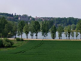
Montigny-le-Gannelon (original) (raw)
From Wikipedia, the free encyclopedia
Part of Cloyes-les-Trois-Rivières in Centre-Val de Loire, France
| Montigny-le-Gannelon | |
|---|---|
| Part of Cloyes-les-Trois-Rivières | |
 |
|
Location of Montigny-le-Gannelon  |
|
  Montigny-le-GannelonShow map of France Montigny-le-GannelonShow map of France  Montigny-le-GannelonShow map of Centre-Val de Loire Montigny-le-GannelonShow map of Centre-Val de Loire |
|
| Coordinates: 48°00′54″N 1°14′07″E / 48.015°N 1.2353°E / 48.015; 1.2353 | |
| Country | France |
| Region | Centre-Val de Loire |
| Department | Eure-et-Loir |
| Arrondissement | Châteaudun |
| Canton | Brou |
| Commune | Cloyes-les-Trois-Rivières |
| Area1 | 8.95 km2 (3.46 sq mi) |
| Population (2019)[1] | 449 |
| • Density | 50/km2 (130/sq mi) |
| Demonym | Montrognons |
| Time zone | UTC+01:00 (CET) |
| • Summer (DST) | UTC+02:00 (CEST) |
| Postal code | 28220 |
| Elevation | 92–152 m (302–499 ft) (avg. 140 m or 460 ft) |
| 1 French Land Register data, which excludes lakes, ponds, glaciers > 1 km2 (0.386 sq mi or 247 acres) and river estuaries. |
Montigny-le-Gannelon (French pronunciation: [mɔ̃tiɲi lə ɡanlɔ̃]) is a former commune in the Eure-et-Loir department in northern France. On 1 January 2017, it was merged into the new commune Cloyes-les-Trois-Rivières.[2]
Historical population
| Year | Pop. | ±% |
|---|---|---|
| 1962 | 315 | — |
| 1968 | 369 | +17.1% |
| 1975 | 349 | −5.4% |
| 1982 | 334 | −4.3% |
| 1990 | 388 | +16.2% |
| 1999 | 426 | +9.8% |
| 2008 | 495 | +16.2% |
- ^ Téléchargement du fichier d'ensemble des populations légales en 2019, INSEE
- ^ Arrêté préfectoral 25 May 2016 (in French)