Niederriedsee (original) (raw)
From Wikipedia, the free encyclopedia
Reservoir in Canton of Bern
| Niederriedsee | |
|---|---|
 |
|
  NiederriedseeShow map of Canton of Bern NiederriedseeShow map of Canton of Bern  NiederriedseeShow map of Switzerland NiederriedseeShow map of Switzerland  NiederriedseeShow map of Alps NiederriedseeShow map of Alps |
|
| Location | Canton of Bern |
| Coordinates | 46°59′52″N 7°14′28″E / 46.99778°N 7.24111°E / 46.99778; 7.24111 |
| Type | reservoir |
| Primary inflows | Aare |
| Primary outflows | Aare |
| Basin countries | Switzerland |
| Surface area | 1.5 km2 (0.58 sq mi) |
| Max. depth | 8 m (26 ft) |
| Surface elevation | 461 m (1,512 ft) |
| Ramsar Wetland | |
| Official name | Niederried Stausee |
| Designated | 9 November 1990 |
| Reference no. | 508[1] |
 |
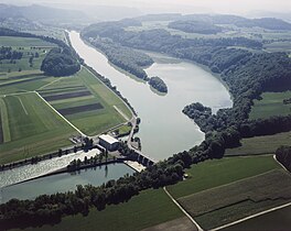
Niederriedsee (or Stausee Niederried) is a reservoir formed by the Niederried dam on the Aar River in the canton of Bern, Switzerland. It is named after the nearby village Niederried bei Kallnach.
- ^ "Niederried Stausee". Ramsar Sites Information Service. Retrieved 25 April 2018.