Nieuwerbrug (original) (raw)
From Wikipedia, the free encyclopedia
Village in South Holland, Netherlands
| Nieuwerbrug Nieuwerbrug aan de Rijn | |
|---|---|
| Village | |
 Centre of Nieuwerbrug with the church and toll bridge Centre of Nieuwerbrug with the church and toll bridge |
|
  NieuwerbrugLocation in the province of South Holland in the NetherlandsShow map of South Holland NieuwerbrugLocation in the province of South Holland in the NetherlandsShow map of South Holland NieuwerbrugLocation in the NetherlandsShow map of Netherlands NieuwerbrugLocation in the NetherlandsShow map of Netherlands |
|
| Coordinates: 52°4′37″N 4°48′56″E / 52.07694°N 4.81556°E / 52.07694; 4.81556 | |
| Country | Netherlands |
| Province | South Holland |
| Municipality | Bodegraven-Reeuwijk |
| Area[1] | |
| • Total | 12.02 km2 (4.64 sq mi) |
| Elevation[2] | 0.3 m (1.0 ft) |
| Population (2021)[1] | |
| • Total | 1,790 |
| • Density | 150/km2 (390/sq mi) |
| Time zone | UTC+1 (CET) |
| • Summer (DST) | UTC+2 (CEST) |
| Postal code | 2415[1] |
| Dialing code | 0348 |
Nieuwerbrug (also Nieuwerbrug aan de Rijn) is a village in the Dutch province of South Holland. It is a part of the former municipality of Bodegraven, and lies about five kilometres west of Woerden. Bodegraven has become part of the municipality of Bodegraven-Reeuwijk in 2011. Nieuwerbrug aan de Rijn is the spelling since 2009 to distinguish from Nieuwebrug in Friesland.[3]
Nieuwerbrug is a dike village which developed along the bridge over the Oude Rijn which was built in 1510. The bridge became a toll bridge from 1651 to the present. A little tower was built next to the bridge between 1913 and 1914.[4]
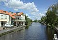
View from the bridge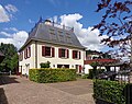
Villa Weijpoort
De Volharding


- ^ a b c "Kerncijfers wijken en buurten 2021". Central Bureau of Statistics. Retrieved 2 May 2022.
- ^ "Postcodetool for 2415AA". Actueel Hoogtebestand Nederland (in Dutch). Het Waterschapshuis. 24 July 2019. Retrieved 2 May 2022.
- ^ "Nieuwerbrug aan de Rijn". Plaatsengids (in Dutch). Retrieved 2 May 2022.
- ^ Ronald Stenvert & Sabine Broekhoven (2004). "Nieuwerbrug" (in Dutch). Zwolle: Waanders. ISBN 90-400-9034-3. Retrieved 2 May 2022.