Nissewaard (original) (raw)
From Wikipedia, the free encyclopedia
Municipality in South Holland, Netherlands
| Nissewaard | |
|---|---|
| Municipality | |
 City centre of Spijkenisse City centre of Spijkenisse Geervliet, windmill: de Bernissemolen Geervliet, windmill: de Bernissemolen Heenvliet market Heenvliet market |
|
 Flag Flag Coat of arms Coat of arms |
|
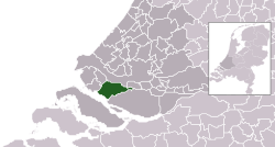
 Location in South Holland Location in South Holland |
|
| Coordinates: 51°49′42″N 4°16′45″E / 51.8283°N 4.2792°E / 51.8283; 4.2792 | |
| Country | Netherlands |
| Province | South Holland |
| Established | 1 January 2015[1] |
| Government[2] | |
| • Body | Municipal council |
| • Mayor (acting) | Foort van Oosten (VVD) |
| Area[3] | |
| • Total | 83.79 km2 (32.35 sq mi) |
| • Land | 73.58 km2 (28.41 sq mi) |
| • Water | 10.21 km2 (3.94 sq mi) |
| Population (January 2021)[4] | |
| • Total | 85,440 |
| • Density | 1,161/km2 (3,010/sq mi) |
| Time zone | UTC+1 (CET) |
| • Summer (DST) | UTC+2 (CEST) |
| Postcode | 3200–3209, 3211, 3212, 3214, 3216, 3218, 3227 |
| Area code | 0181 |
| Website | www.nissewaard.nl |
Nissewaard (Dutch pronunciation: [ˈnɪsəˌʋaːrt]) is a municipality in the Netherlands, located on the island of Voorne-Putten, in the south of the province of South Holland. It was created through a merger of the municipalities of Spijkenisse and Bernisse on 1 January 2015.
Nissewaard has a population of about 85,000 as of 2014.
Dutch topographic map of the municipality of Nissewaard, June 2015
Dirk van Hogendorp, c. 1813
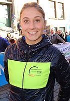
Chanella Stougje, 2016
- Dirk van Hogendorp (1761 in Heenvliet – 1822), Dutch officer and author
- Jan Campert (1902 in Spijkenisse – 1943) a journalist, theater critic and writer
- Marleen de Pater-van der Meer (1950 in Hekelingen – 2015) a Dutch politician
- Jan Bechtum (born 1958 in Spijkenisse) a Dutch guitarist and composer
- Erik de Jong (born 1961 in Spijkenisse) known as Spinvis, a Dutch one-man music project
- Medy van der Laan (born 1968 in Spijkenisse) a retired Dutch politician
- Alexander van Oudenaarden (born 1970 in Zuidland) a Dutch biophysicist and systems biologist
- Sied van Riel (born 1978) a Dutch trance music DJ and producer, lives in Spijkenisse
- Björn Franken (born 1983 in Spijkenisse) known as Vato Gonzalez, DJ and producer
- Nick van de Wall (born 1987 in Spijkenisse) known as Afrojack, DJ and producer
- Duncan Laurence (born 1994 in Spijkenisse) singer, winner of the Eurovision Song Contest 2019
- Bram Groeneweg (1905 in Spijkenisse – 1988) a Dutch long-distance runner, competed in the marathon at the 1928 Summer Olympics
- Emiel Mellaard (born 1966 in Spijkenisse) is a retired Dutch long jump record holder
- Maarten den Bakker (born 1969 in Abbenbroek) a retired road bicycle racer, competed in the 1988 Summer Olympics
- Joeri de Groot (born 1977 in Spijkenisse) a Dutch rower, competed at the 2004 Summer Olympics
- Patrick van Luijk (born 1984 in Spijkenisse) a Dutch sprinter
- Martijn Barto (born 1984 in Spijkenisse) a Dutch professional footballer with over 200 club caps
- Chanella Stougje (born 1996 in Zuidland) a Dutch professional racing cyclist
- ^ "Gemeentelijke indeling op 1 januari 2015" [Municipal divisions on 1 January 2015]. cbs.nl (in Dutch). CBS. Retrieved 9 November 2018.
- ^ "Burgemeester Foort van Oosten" [Mayor Foort van Oosten] (in Dutch). Gemeente Nissewaard. Retrieved 26 September 2019.
- ^ "Kerncijfers wijken en buurten 2020" [Key figures for neighbourhoods 2020]. StatLine (in Dutch). CBS. 24 July 2020. Retrieved 19 September 2020.
- ^ "Bevolkingsontwikkeling; regio per maand" [Population growth; regions per month]. CBS Statline (in Dutch). CBS. 1 January 2021. Retrieved 2 January 2022.
- Official website (in Dutch)


