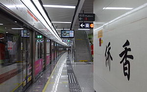
Qiaoxiang station (original) (raw)
From Wikipedia, the free encyclopedia
Metro station in Shenzhen, China
Qiaoxiang侨香 |
|
|---|---|
 |
|
| Chinese name | |
| Traditional Chinese | 僑香 |
| Simplified Chinese | 侨香 |
| TranscriptionsStandard MandarinHanyu PinyinQiáo XiāngYue: CantoneseJyutpingKiu4 Hoeng1 | |
| General information | |
| Location | Futian District, Shenzhen, GuangdongChina |
| Operated by | SZMC (Shenzhen Metro Group) |
| Line(s) | Line 2 |
| Platforms | 2 (1 island platform) |
| Tracks | 2 |
| Construction | |
| Structure type | Underground |
| Accessible | Yes |
| Other information | |
| Station code | 216 |
| History | |
| Opened | 28 June 2011; 13 years ago (2011-06-28) |
| Services | |
Preceding station  Shenzhen Metro Following station Antuo Hilltowards Chiwan Line 2 Xiangmitowards Liantang Shenzhen Metro Following station Antuo Hilltowards Chiwan Line 2 Xiangmitowards Liantang |
|
Route map  Xiangmi) Xiangmi)  Antuo Hill) Antuo Hill) |
Qiaoxiang station (simplified Chinese: 侨香站; traditional Chinese: 僑香站; pinyin: Qiáoxiāng Zhàn; Jyutping: kiu4 hoeng1 zaam6) is a station of Shenzhen Metro Line 2. It opened on 28 June 2011. It is located nearby the Qiaoxiang Road.
| G | - | Exit |
|---|---|---|
| B1FConcourse | Lobby | Customer Service, Shops, Vending machines, ATMs |
| B2FPlatforms | Platform 1 | ← Line 2 towards Chiwan (Antuo Hill) |
| Island platform, doors will open on the left | ||
| Platform 2 | Line 2 towards Yantian Road (Xiangmi) → |
| Exit | Destination | |
|---|---|---|
| Exit A | Qiaoxiang Road, Shenzhen Ophthalmologic Hospital, Economic Crime Investigation Bureau of Shenzhen Public Security Bureau, Guohua Building, Hongyunge, Shenzhen Municipal Corps of Chinese People's Armed Police Force, New Global Horse | |
| Exit B | Nongyuan Road, Runtian Road, Shenzhen Senior High School, Xiangyu Central Garden Phase I, Liyuan Foreign Language Primary School | |
| Exit C | C1 | Qiaoxiang Road (E), Cuihai Garden, Qiaoxiang Xincun, Futian Foreign Language School, Jindi Xiangmishan Residence, Xiangge Liyuan, Vanke Wenxin Homestead, Shenzhen Housing Provident Fund Management Center |
| C2 | Qiaoxiang Road (W) |
- Shenzhen Metro official page (Chinese)
- Shenzhen Metro official page (English)
- Street map
22°33′0″N 114°0′52″E / 22.55000°N 114.01444°E / 22.55000; 114.01444