Yuncheng (original) (raw)
Not to be confused with Yancheng.
Prefecture-level city in Shanxi, People's Republic of China
| Yuncheng 运城市 | |
|---|---|
| Prefecture-level city | |
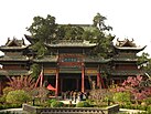
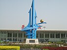
    Top to bottom, left to right: Haizhou Emperor Guan Temple, Yuncheng Salt Lake, Yuncheng Airport, Nanfeng Plaza Top to bottom, left to right: Haizhou Emperor Guan Temple, Yuncheng Salt Lake, Yuncheng Airport, Nanfeng Plaza |
|
 Location of Yuncheng City jurisdiction in Shanxi Location of Yuncheng City jurisdiction in Shanxi |
|
  YunchengLocation of the city center in ShanxiShow map of Shanxi YunchengLocation of the city center in ShanxiShow map of Shanxi  YunchengYuncheng (Eastern China)Show map of Eastern China YunchengYuncheng (Eastern China)Show map of Eastern China  YunchengYuncheng (China)Show map of China YunchengYuncheng (China)Show map of China |
|
| Coordinates (Yulin municipal government): 35°01′36″N 111°00′25″E / 35.0267°N 111.0070°E / 35.0267; 111.0070 | |
| Country | People's Republic of China |
| Province | Shanxi |
| County-level divisions | 13 |
| Municipal seat | Yanhu District |
| Government | |
| • Type | Prefecture-level city |
| • Communist Party Secretary | Wang Yuyan |
| • Mayor | Wang Qingxian (王清宪) |
| Area | |
| • Prefecture-level city | 14,183 km2 (5,476 sq mi) |
| • Urban | 1,205 km2 (465 sq mi) |
| • Metro | 1,205 km2 (465 sq mi) |
| Elevation | 370 m (1,210 ft) |
| Population (2020 census)[1] | |
| • Prefecture-level city | 4,774,508 |
| • Density | 340/km2 (870/sq mi) |
| • Urban | 928,334 |
| • Urban density | 770/km2 (2,000/sq mi) |
| • Metro | 928,334 |
| • Metro density | 770/km2 (2,000/sq mi) |
| GDP[2] | |
| • Prefecture-level city | CN¥ 164.4 billionUS$ 25.8 billion |
| • Per capita | CN¥ 34,425US$ 5,508 |
| Time zone | UTC+8 (China Standard) |
| Postal code | 044000 |
| Area code | 0359 |
| ISO 3166 code | CN-SX-08 |
| License Plate | 晋M |
| Administrative division code | 140800 |
| Yuncheng | |
|---|---|
| Simplified Chinese | 运城 |
| Traditional Chinese | 運城 |
| TranscriptionsStandard MandarinHanyu PinyinYùnchéngWade–GilesYün-ch‘êng | |
Yuncheng is the southernmost prefecture-level city in Shanxi province, People's Republic of China. It borders Linfen and Jincheng municipalities to the north and east, and Henan (Luoyang and Jiyuan to the east, Sanmenxia to the south) and Shaanxi (Weinan) provinces to the east, south and west, respectively. As of the 2020 census, its population was 4,774,508 inhabitants (5,134,779 in 2010), of whom 928,334 (680,036 in 2010) lived in the built-up (or metro) area made of Yanhu District. One can note than Pinglu County, 205,080 inhabitants in the south, is now part of Sanmenxia built-up (or metro) area.
Map including Yuncheng (labeled as YÜN-CH'ENG 運城) (AMS, 1958)
[![[icon]](http://upload.wikimedia.org/wikipedia/commons/thumb/1/1c/Wiki_letter_w_cropped.svg/20px-Wiki_letter_w_cropped.svg.png) ](/wiki/File:Wiki%5Fletter%5Fw%5Fcropped.svg) ](/wiki/File:Wiki%5Fletter%5Fw%5Fcropped.svg) |
This section needs expansion. You can help by adding to it. (August 2012) |
|---|
In early China,[_when?_] it was the location of the state of Kunwu (昆吾). Yuncheng was the site of the Yuncheng Campaign (三打运城), battle between the Kuomintang army and the People's Liberation Army during Chinese civil war.
The famous general Guan Yu from the late Han dynasty was also born in this region.
In July 2022, archaeologists announced a discovery of a 2.8 cm long 5.200 years old stone carving chrysalis in a semi-crypt house at the Shangguo Site in Wenxi County. Archaeologists made suppositions that this house may have belonged to the Yangshao Culture period, based on the unearthed pottery pieces. According to archaeologist Tian Jianwen, discovery of stone carving chrysalises provided significant information for the study of the silkworm culture in China.[3][4]
There are 13 county-level administrative divisions under Yuncheng's jurisdiction, including 1 district, 10 counties and 2 county-level cities. The Municipal executive, legislature and judiciary are in Yanhu District (盐湖区), together with the CPC and Public Security Bureau.
| Map | |||||
|---|---|---|---|---|---|
 Yanhu Linyi County Wanrong County Wenxi County Jishan County Xinjiang County Jiang County Yuanqu County Xia County Pinglu County Ruicheng County Yongji (city) Hejin (city) Yanhu Linyi County Wanrong County Wenxi County Jishan County Xinjiang County Jiang County Yuanqu County Xia County Pinglu County Ruicheng County Yongji (city) Hejin (city) |
|||||
| Name | Chinese | Hanyu Pinyin | Population (2010) | Area (km2) | Density (/km2) |
| Yanhu District | 盐湖区 | Yánhú Qū | 680,036 | 1,237 | 501 |
| Yongji City | 永济市 | Yǒngjì Shì | 444,724 | 1,221 | 352 |
| Hejin City | 河津市 | Héjīn Shì | 395,527 | 593 | 607 |
| Ruicheng County | 芮城县 | Ruìchéng Xiàn | 394,849 | 1,161 | 327 |
| Linyi County | 临猗县 | Línyī Xiàn | 572,508 | 1,350 | 393 |
| Wanrong County | 万荣县 | Wànróng Xiàn | 439,364 | 1,037 | 405 |
| Xinjiang County | 新绛县 | Xīnjiàng Xiàn | 332,473 | 600 | 533 |
| Xia County | 夏县 | Xià Xiàn | 352,821 | 1,328 | 264 |
| Jishan County | 稷山县 | Jìshān Xiàn | 347,425 | 680 | 485 |
| Wenxi County | 闻喜县 | Wénxǐ Xiàn | 404,150 | 1,160 | 328 |
| Jiang County | 绛县 | Jiàng Xiàn | 281,643 | 968 | 279 |
| Pinglu County | 平陆县 | Pínglù Xiàn | 258,241 | 1,151 | 217 |
| Yuanqu County | 垣曲县 | Yuánqǔ Xiàn | 231,018 | 1,620 | 136 |
Yuncheng has a continental, monsoon-influenced semi-arid climate (Köppen BSk), with four distinct seasons.[5] Due to its southerly location and position to the north of the Zhongtiao Mountains, allowing for downsloping when winds are from the south, it is among the warmest locales in the province. Winters are cold and very dry, while summers are hot and humid. Monthly mean temperatures range from −0.6 °C (30.9 °F) in January to 27.5 °C (81.5 °F) in July, and the annual mean is 14.23 °C (57.6 °F). Over 60% of the annual rainfall occurs from June to September. With monthly percent possible sunshine ranging from 45% in March to 54% in May and July, the city receives 2,219 hours of bright sunshine annually, low by Shanxi standards and North China.
| Climate data for Yuncheng (Yanhu District), elevation 375 m (1,230 ft), (1991–2020 normals, extremes 1951–2010) | |||||||||||||
|---|---|---|---|---|---|---|---|---|---|---|---|---|---|
| Month | Jan | Feb | Mar | Apr | May | Jun | Jul | Aug | Sep | Oct | Nov | Dec | Year |
| Record high °C (°F) | 16.4(61.5) | 25.2(77.4) | 29.6(85.3) | 37.6(99.7) | 40.2(104.4) | 42.7(108.9) | 41.4(106.5) | 40.8(105.4) | 40.0(104.0) | 33.2(91.8) | 25.3(77.5) | 17.5(63.5) | 42.7(108.9) |
| Mean daily maximum °C (°F) | 5.4(41.7) | 10.0(50.0) | 16.4(61.5) | 23.1(73.6) | 28.1(82.6) | 32.3(90.1) | 33.2(91.8) | 31.5(88.7) | 26.7(80.1) | 20.5(68.9) | 13.1(55.6) | 6.6(43.9) | 20.6(69.0) |
| Daily mean °C (°F) | −0.6(30.9) | 3.7(38.7) | 9.8(49.6) | 16.4(61.5) | 21.6(70.9) | 26.2(79.2) | 27.8(82.0) | 26.2(79.2) | 21.1(70.0) | 14.6(58.3) | 7.0(44.6) | 0.7(33.3) | 14.5(58.2) |
| Mean daily minimum °C (°F) | −5.1(22.8) | −1.3(29.7) | 4.3(39.7) | 10.2(50.4) | 15.3(59.5) | 20.3(68.5) | 23.2(73.8) | 21.9(71.4) | 16.7(62.1) | 10.0(50.0) | 2.5(36.5) | −3.7(25.3) | 9.5(49.1) |
| Record low °C (°F) | −18.9(−2.0) | −16.2(2.8) | −10.8(12.6) | −5.0(23.0) | 2.9(37.2) | 11.0(51.8) | 15.4(59.7) | 12.3(54.1) | 2.6(36.7) | −4.9(23.2) | −11.6(11.1) | −16.0(3.2) | −18.9(−2.0) |
| Average precipitation mm (inches) | 4.9(0.19) | 8.1(0.32) | 14.0(0.55) | 37.4(1.47) | 48.9(1.93) | 54.9(2.16) | 87.7(3.45) | 81.9(3.22) | 81.2(3.20) | 51.9(2.04) | 22.6(0.89) | 3.6(0.14) | 497.1(19.56) |
| Average precipitation days (≥ 0.1 mm) | 2.9 | 3.0 | 4.1 | 6.4 | 7.4 | 7.5 | 8.7 | 8.7 | 9.4 | 7.4 | 4.9 | 2.2 | 72.6 |
| Average snowy days | 3.3 | 2.4 | 1.0 | 0.1 | 0 | 0 | 0 | 0 | 0 | 0 | 1.2 | 2.2 | 10.2 |
| Average relative humidity (%) | 55 | 53 | 51 | 53 | 53 | 54 | 64 | 68 | 69 | 69 | 67 | 59 | 60 |
| Mean monthly sunshine hours | 131.1 | 139.1 | 176.4 | 210.4 | 231.4 | 222.1 | 221.2 | 200.8 | 158.0 | 144.7 | 132.8 | 136.0 | 2,104 |
| Percent possible sunshine | 42 | 45 | 47 | 53 | 53 | 51 | 50 | 49 | 43 | 42 | 43 | 45 | 47 |
| Source: China Meteorological Administration[6][7][8] |
- Guan Yu, general and deified historical figure
- Jing Haipeng, PLAAC astronaut
- Zhang Ziyi, Chinese zootechnician
- Gladys Aylward, British missionary who works in the city in the 1930s
- China National Highway 209
- G59 Hohhot–Beihai Expressway
- Datong–Xi'an Passenger Railway, with frequent service to Beijing, Taiyuan, and Xi'an.[9] Besides the Yuncheng North Railway Station (near Yuncheng's central city), the railway also has stations at Yongji and Wenxi.
- Yuncheng Zhangxiao Airport
Notes and references
[edit]

Wikimedia Commons has media related to Yuncheng.
- ^ "China: Shānxī (Prefectures, Cities, Districts and Counties) - Population Statistics, Charts and Map".
- ^ 山西省统计局、国家统计局山西调查总队 (December 2021). 《山西统计年鉴-2021》. 中国统计出版社. ISBN 978-7-5037-7824-7.
- ^ "5,200-year-old stone carving chrysalis found in north China-Xinhua". www.chinaview.cn. Retrieved 24 July 2022.
- ^ Büyükyıldırım, Oğuz (19 July 2022). "5,200-year-old stone carving silkworm chrysalis discovered in north China". Arkeonews. Retrieved 24 July 2022.
- ^ "Updated Asian Map of the Köppen system". wikimedia.org. Retrieved 5 April 2018.
- ^ 中国气象数据网 – WeatherBk Data (in Simplified Chinese). China Meteorological Administration. Retrieved 26 August 2023.
- ^ 中国气象数据网 (in Simplified Chinese). China Meteorological Administration. Retrieved 26 August 2023.
- ^ 中国地面国际交换站气候标准值月值数据集(1971-2000年). China Meteorological Administration. Archived from the original on 21 September 2013. Retrieved 25 May 2010.
- ^ Yuncheng North schedule Archived 28 May 2015 at the Wayback Machine (in Chinese)
