AirNav: M99 - Shady Lane Airport (original) (raw)
Location
| FAA Identifier: |
M99 |
| Lat/Long: |
43-03-40.3200N 084-32-54.2000W43-03.672000N 084-32.903333W43.0612000,-84.5483889(estimated) |
| Elevation: |
680 ft. / 207 m (estimated) |
| From city: |
4 miles N of ST JOHNS, MI |
| Time zone: |
UTC -5 (UTC -4 during Daylight Saving Time) |
| Zip code: |
48879 |
Airport Operations
| Airport use: |
Open to the public |
| Activation date: |
04/2018 |
| Control tower: |
no |
| ARTCC: |
CLEVELAND CENTER |
| FSS: |
LANSING FLIGHT SERVICE STATION |
| NOTAMs facility: |
LAN (NOTAM-D service available) |
| Attendance: |
UNATNDD |
| Segmented circle: |
no |
Airport Communications
| CTAF: |
122.9 |
| WX AWOS-3P at AMN (17 nm N): |
124.175 (989-463-3433) |
| WX ASOS at LAN (17 nm S): |
PHONE 517-908-8494 |
| WX AWOS-3 at RNP (18 nm E): |
118.025 (989-729-2967) |
Nearby radio navigation aids
| VOR radial/distance | | VOR name | | Freq | | Var |
| ---------------------------------------------------------------------------- | ---------------------- | -------- | --- | ---- | | --- |
| MOPr171/34.7 | MOUNT PLEASANT VOR/DME | 110.60 | 05W | | | |
| MBSr219/34.9 | SAGINAW VOR/DME | 114.35 | 03W | | | |
| FNTr285/35.6 | FLINT VORTAC | 116.90 | 06W | | | |
Airport Services
Runway 9/27
| Dimensions: |
2302 x 60 ft. / 702 x 18 m |
|
| Surface: |
turf, in fair condition |
|
| RUNWAY 9 |
|
RUNWAY 27 |
| Latitude: |
43-03.669000N |
43-03.675000N |
| Longitude: |
084-33.161667W |
084-32.645000W |
| Elevation: |
680.0 ft. |
680.0 ft. |
| Traffic pattern: |
left |
left |
| Runway heading: |
089 true |
269 true |
| Obstructions: |
50 ft. tree, 560 ft. from runway, 86 ft. right of centerline, 11:1 slope to clear |
59 ft. road, 18 ft. from runway, 125 ft. left and right of centerline, 1:1 slope to clearAPCH RATIO 20:1 TO DTHR. |
Airport Ownership and Management from official FAA records
| Ownership: |
Privately-owned |
| Owner: |
EUGENE JONES1434 W FRENCH RDSAINT JOHNS, MI 48879-9406Phone 517-282-1656 |
| Manager: |
EUGENE JONES1550 W FRENCH RDSAINT JOHNS, MI 48879-9406Phone 517-282-1656 |
| - |
FOR CD CTC GREAT LAKES APCH AT 269-459-3345, WHEN APCH CLSD CTC CLEVELAND ARTCC AT 440-774-0224/0490. |
| - |
DEER, BIRDS, & WILDLIFE ON & INVOF ARPT. |
| - |
OPPOSITE RWY END NOT VSB FM THR DUE TO ROLLING TRRN, +25 FT ELEV CHG. |
| - |
RWY 27 DTHR 1430 FT, EXTDS BYD RWY MIDPT. |
Instrument Procedures
There are no published instrument procedures at M99.
Some nearby airports with instrument procedures:
KAMN - Gratiot Community Airport (17 nm N)
KLAN - Capital Region International Airport (17 nm S)
KRNP - Owosso Community Airport (18 nm E)
4D0 - Abrams Municipal Airport (19 nm SW)
Y70 - Ionia County Airport (24 nm W)
Loc | Ops | Rwys | IFR | FBO | Links
Com | Nav | Svcs | Stats | Notes
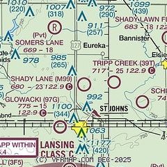
| Aerial photo |
 |
| Sectional chart |
 |
| Airport distance calculator |
| Flying to Shady Lane Airport? Find the distance to fly. From to M99 |
| Sunrise and sunset |
| Times for 10-Mar-2026 Local(UTC-4) Zulu(UTC) Morning civil twilight07:3211:32 Sunrise08:0012:00 Sunset19:3723:37 Evening civil twilight20:0500:05 |
| Current date and time |
| Zulu (UTC) 10-Mar-2026 18:16:35 Local (UTC-4) 10-Mar-2026 14:16:35 |
| METAR |
| KAMN 16nm N 101755Z AUTO 06014KT 10SM OVC016 05/01 A2996 RMK AO2 10059 20046 KLAN 17nm S 101753Z 04010KT 10SM OVC008 07/05 A2994 RMK AO2 SLP140 T00720050 10117 20072 51022 KRNP 18nm E 101755Z AUTO 02006KT 10SM OVC006 04/02 A2996 RMK AO2 T00410018 10077 20035 |
| TAF |
| KLAN 17nm S 101740Z 1018/1118 02003KT 6SM BR OVC006 FM102200 05010KT 6SM BR VCSH OVC010 FM110000 06011G19KT 4SM -SHRA VCTS OVC009CB TEMPO 1102/1106 3SM TSRA FM110600 07009KT 2SM -SHRA BR VCTS OVC004CB FM110900 05007KT 1 1/2SM -SHRA BR OVC006 WS020/23030KT FM111600 27010KT 2SM BR VCSH OVC006 |
 Click for the latest NOTAMs NOTAMs are issued by the DoD/FAA and will open in a separate window not controlled by AirNav.