Part of a letter from Trinity House (original) (raw)
SOME INTERESTING INFORMATION AND FACTS CONCERNING THE HISTORICAL CAPE PINE LIGHTHOUSE

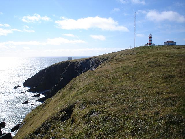
Located on the Southeast Coast of Newfoundland are the Headlands of the Southern Avalon Peninsula - a place of great interest to the early 19th century mariner. A ship westward bound from Europe to ports such as Boston, Halifax or The St. Lawrence River would often make landfall at the Southern Avalon to confirm their position before continuing on the voyage. The same was often true for ships on an east homeward voyage. Or maybe the vessel would accidentally fall in with these headlands when the Captain thought he was many miles seaward. Cape Race was often the landfall headland for a westbound vessel, whereas Cape Pine was the major concern for an eastbound vessel. The two Cape�s are only a mere 25 miles apart, but both quickly earned the respect of the early transatlantic mariner. The bay that separates these two great Capes is called Trepassey Bay, which means �Bay-Of-Death�. Often these headlands proved to be the first glimpse of the New World for many an emigrant to what is now the nation of Canada.
- Unfortunately, a great number of vessels did not make it safely passed the Southern Avalon. The hazards along this part of the coast played havoc with early shipping. It is just off the southeast coast of Newfoundland that the cold Labrador Current meets the warmer Gulf Steam � producing what some say is the worst fog conditions in the world. The tide can often run 3-4 knots passed Cape Pine, taking a ship several miles off course in a few short hours. Icebergs are also very common in late spring and summer � as this area lies in what is referred to as "Iceberg-Alley". Early-mid 1800�s saw an increase in passengers and commerce between Europe and British North America. The number of shipwrecks along the coast at Cape Pine also grew in number. Many vessels were lost with part or entire passengers and crews. Pressure was building for someone to light the Southern Avalon. Given the era of British Imperialism around this time, it is not surprising that the Government of Britain entertained the idea of a lighthouse at Cape Pine. Also, the fact that many of the recent wrecks had been ships belonging to Britain or one of the Colonies. Below is part of a letter from "Trinity House" to the British House of Commons, spring 1847.
� the measure of lighting the Southeast part of Newfoundland would be effectually accomplished by the erection of a Lighthouse on Cape Pine, on the Southeast most extremity of that headland, all vessels bound to or from ports or places situate between St. Johns and Cape Cod, including River St. Lawrence, would be benefited by the establishment of a lighthouse on the above mention situation.�
Source: �The First Landfall� David J. Molloy, Breakwater
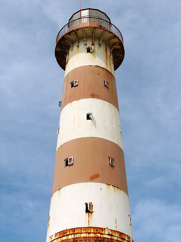
� The British House of Commons passed an act agreeing to pay the capital cost to establish a lighthouse at Cape Pine. Things begin to happen later that same year of 1847, well-known Civil Engineer and Building Designer - Alexander Gordon was given the contract to design and build the Cape Pine Lighthouse. The sixty-five foot cast iron lighthouse was Gordon�s third such lighthouse project to be prefabricated in England and shipped in dozens of sections to the New World. This would be his first for Newfoundland. Meanwhile in 1847, the British Admiralty sent out Captain Henry Bayfield to survey Cape Pine for an exact location of the lighthouse. Capt. Bayfield's description of Cape Pine. The Cape Pine lighthouse pieces were landed with great difficultly on that rugged and treacherous headland on the Southern Avalon. The erection of the tower was completed in late 1850, the light was first lit on New Year's day 1851. Alexander Gordon and Cast Iron
� The new Lighthouse greatly aided shipping bound to/from North America and Europe. This would make Cape Pine the very FIRST �International Lighthouse� established on the coast of Newfoundland. It was the first landfall light established on the southeast coast of Newfoundland, several years before Cape Race.
� Cape Pine is the southern most light in Newfoundland, on one of its most prominent headlands. Standing 350 feet above sea level - it overlooks Trepassey Bay to the east and St. Mary's Bay to the west.
� The station was manned by several generations of the Hewitt family for over 100 years; other keepers included the Myrick's and Finlay's. Sad to say - the lighthouse was automated and de-staffed in 1996, the last light keeper being Peter Myrick. The lighthouse was given historical-status in the late 1970�s by the Government of Canada, and has been designated a �National Historic Site�.
� The first light to be fitted at Cape Pine was a 40-year old mechanism from the Isle of May in Scotland. Some years later, it would serve at Cape Bonavista Lighthouse - where it is on display today.
� Today, the original Cape Pine Lighthouse stands as the third oldest Lighthouse structure in the province. It was the first cast-iron lighthouse to be built in Newfoundland. Newfoundland became the tenth province of Canada in 1949, thus making Cape Pine the oldest cast-iron lighthouse in Canada. The choice of building material (cast-iron) has indeed proven to be a wise one, the tower remains today in great structural condition - a true testament to Alexander Gordon and his design
No - this is not a picture of Cape Pine Lighthouse, but its sister to the south..... what's the connection? read more
