History walk | Hatley (original) (raw)
By Ishbel Beatty
Starting at Hatley St George church (above is the view from the south door), we shall find our way through two Cambridgeshire villages, looking at landmarks which remind us of their past.
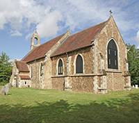
Hatley St George church, 8 August 2015. Regular services are held every second and fourth Sunday of the month. Click on the photos for larger images.
We cling to our Cambridgeshire identity, although we are meant to use the postal address of Bedfordshire. Hatley St George, once known as Hungry Hatley because of the nature of its soil, has been a separate parish from East Hatley (once known as Castell Hatley) since mediæval times. The two were united as a civil parish in 1957, and are nowadays included ecclesiastically in the parish of Gamlingay.
Through the ages there have been changes of land ownership and of boundaries: names change, buildings change, only some of them remain. If we start with the church, now a chapel of ease, to whom is it dedicated? Fourteen generations of the family of Saint George have stamped their name on the village, but it is not certain that the church is named after that saint. One 20th century ecclesiastic insisted that it should be called St James the Greater, but that question is still not resolved.
Looking at what remains of the church building, thought to have been erected in 1352, we can see how its length has been truncated by the collapse of the chancel. Rebuilding and refurbishing in the late 19th century has given us its present shape, and also the head of Queen Victoria as an arch-stop at the porch door.
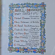
WWI Roll of Honour to the fallen of East Hatley in Hatley St George church, Cambridgeshire.
Inside, you can read the names on the hatchments, funerary shields of painted wood, hanging along the walls and bearing the names of many St Georges from the 14th and 15th centuries, and of the Cottons, the family who bought the estate in 1658. Sir John Cotton had the shields repainted in 1690.
Since that time, there have been a number of different owners of house and land, and some of their memorial tablets are on the church walls: Pearse, Quintins, Carbery Evans. The Quintins changed their name to St Quintin while living here, taking the style of their Yorkshire ancestors.
There are memorial brasses of a 15th century Baldwin St George and of Catherine Docwra of East Hatley; and there are Rolls of Honour with the names of men from both Hatleys who served in the two World Wars.
A glance to the south-west from outside the church will show you the ‘pritty gentleman-like seate’ of Hatley Park, as it was described in the 17th century, the house now somewhat altered by later building and rebuilding. The park around takes up about one-third of the parish acreage.
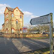
St George’s Tower rural business park, Hatley St George, February 2018.
Turning along the Gamlingay-Croydon road to the east, we pass what were once the stables and piggeries of a 19th century Model Farm, now converted to offices and workshops. St George’s Tower, built in Victorian times as a water tower, has only recently acquired this name. Further along are estate cottages of the same period as the farm. The last building in this style, once the New George Inn, bears the date 1850 and the initials of one of the St Quintins.
To our right now is a remnant of the once well-wooded landscape. The ‘ley’ in Hatley means woodland clearing which indicates how the early settlement began here. The Domesday Book gives East Hatley a population of 24, and its peak of 164 was reached in 1861. Hatley St George’s inhabitants numbered 100 in 1793. The figure for the combined villages today is about 250. Buff Wood, managed by a Wildlife Trust, takes its name from an 18th century farming tenant.
Hatley Village Hall on a typical first-Tuesday-of-the-month Coffee Morning. The Hall is available for hire any day or evening.
The Village Hall on our right was erected by the Astor family about 1960. Open fields appear now on either side of the road until we come to the old school house, erected for the children of the two villages in 1872. The school taught its pupils until 1965 and was then closed because of a decline in numbers. Virtually all the hedges north of the road between the two villages were planted between 1987 and 1997.
A footpath on your right will take you across the field directly to what remains of the old parish church of St Denis, East Hatley, but you may prefer to continue along the road to the main turning into the house-lined street which comprises most of today’s village. Near to the telephone box, notice an oak tree which was planted in 1952 to commemorate the accession to the throne of Queen Elizabeth II. On the corner stood the village smithy, much used when horses provided power for agricultural machinery.
St Denis’ church East Hatley – the east end – 22nd July 2017. The church, which dates from 1217, was substantially restored in 1874 by William Butterfield, the noted 19th century architect, and last used for worship in 1959. It is now owned by The Friends of Friendless Churches.
Among the 20th century in-filling, you can pick out the few 19th century cottages which were once all that East Hatley consisted of. There are no visible remains of the mediæval village apart from the crumbling walls of the church of St Denis which closed 40 or more years ago, while its graveyard is still in use. The church (but not the graveyard) is now owned by The Friends of Friendless Churches. Next to it is the old farmhouse which took the manor name and perhaps contains a few timbers of the house once occupied by East Hatley’s most famous connection, Sir George Downing.
Sir George was given his baronetcy by Charles II after he adroitly switched sides after the Civil War. He is mentioned, not to his advantage, in Samuel Pepys’ famous diary. He has left a carving of his arms with the date 1673 inside the porch of the church and his name is known nationally, not only because of Downing Street, but because his grandson, the third Sir George, left the family fortune to found Downing College, Cambridge.
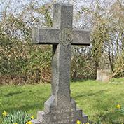
John Perkins’ grave in St Denis’ churchyard, East Hatley on 14th March 2016. The daffodils were planted in his memory – his sister Martha is in the next grave.
It was the College which managed the farming estate of East Hatley from the early 1800s until 1947, when the land was divided up and sold. Before that, in the 1860s, was built the last house of the village street, nicknamed The Palace by locals. This was used by the farming and hunting Bursar on his visits. A flamboyant character, Dr John Perkins was laid to rest in the churchyard in 1901.
Both the churchyard and the field next to The Palace are surrounded by moats. Within the latter stood the parsonage which burned down in 1821. Mysteriously, and surprisingly, there were once 12 or 13 moats in East Hatley.
We now reach another part of Buff Wood, where the remains of another manor house have been identified. Walking round the wood’s outer edge will reveal some of the wide arable landscape of Bedfordshire and beyond. We turn eventually up Buff Lane (the old “hundred” boundary) and arrive again at Hatley St George.
First published on the original Hatley website in 2007; minor changes made on 4th July 2018.
![Hatley St George church, Cambridgeshire - 8 August 2015 [IMG_2995]. Regular services are held every second and fourth Sunday of the month.](https://www.hatley.info/wp-content/uploads/2018/06/Hatley-St-George-church-8-August-2015-IMG_2995-Square-pic-%E2%80%93-177-x-177-px-1.jpg) ](
](


