Topography and Digital Terrain Data (original) (raw)
 |
|---|
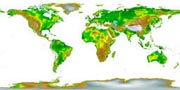
| Global Land One-km Base Elevation (GLOBE) |
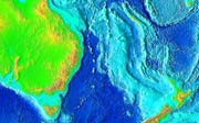 |
| Global Relief Data - Combined Topography and Bathymetry |
| Topographic data are vital for many scientific, technical, and other applications. Even when not used directly in a study, topographic data are often used in preparing visualization tools such as perspective or stereoscopic views of terrain. |
Topographic Data and Images
Gridded Global Topography
The Global Land One-kilometer Base Elevation (GLOBE) Project is a 30-arc-second (1-km) gridded, quality-controlled global Digital Elevation Model (DEM). Check the Gallery of GLOBE Images for some great map-like graphic arts from GLOBE.
Combined Topography & Bathymetry
Global Relief. NCEI's ETOPO1 is a 1 arc-minute global relief model of Earth's surface that integrates land topography and ocean bathymetry. It was built from numerous global and regional data sets, and is available in "Ice Surface" (top of Antarctic and Greenland ice sheets) and "Bedrock" (base of the ice sheets) versions. HistoricETOPO2v2 andETOPO5 global relief grids are deprecated but still available.
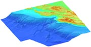
Integrated Models of Coastal Relief. NCEI builds and distributes high-resolution, coastal digital elevation models (DEMs) that integrate ocean bathymetry and land topography. They can be used for modeling of coastal processes (tsunami inundation, storm surge, sea-level rise, contaminant dispersal, etc.), ecosystems management and habitat research, coastal and marine spatial planning, and community hazard mitigation and preparedness.
NOAA Tsunami Inundation DEMs. NCEI builds and distributes high-resolution digital elevation models (DEMs) of select U.S. coastal regions. These integrated bathymetric-topographic DEMs are used to support tsunami forecasting and modeling efforts at the NOAA Center for Tsunami Research.
 |
|---|
| Integrated Models of Coastal Relief - Combined Topography and Bathymetry |