Storm Prediction Center Feb 28, 2017 1630 UTC Day 1 Convective Outlook (original) (raw)
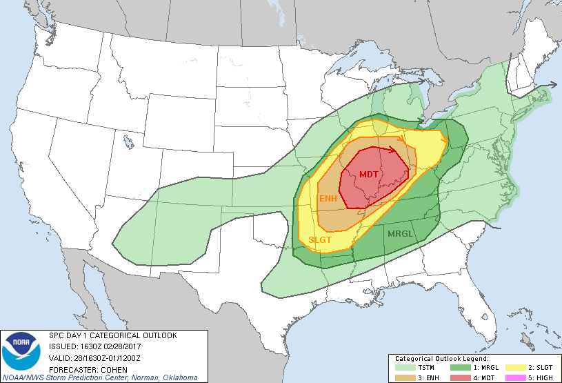
Categorical Graphic

| Day 1 Risk | Area (sq. mi.) | Area Pop. | Some Larger Population Centers in Risk Area |
|---|---|---|---|
| MODERATE | 80,322 | 10,245,409 | Indianapolis, IN...St. Louis, MO...Louisville, KY...Springfield, IL...Evansville, IN... |
| ENHANCED | 94,255 | 10,312,326 | Cincinnati, OH...Dayton, OH...Springfield, MO...Joliet, IL...Peoria, IL... |
| SLIGHT | 136,659 | 23,243,650 | Chicago, IL...Columbus, OH...Memphis, TN...Lexington-Fayette, KY...Fort Wayne, IN... |
| MARGINAL | 193,965 | 29,017,413 | Milwaukee, WI...Nashville, TN...Kansas City, MO...Cleveland, OH...Atlanta, GA... |
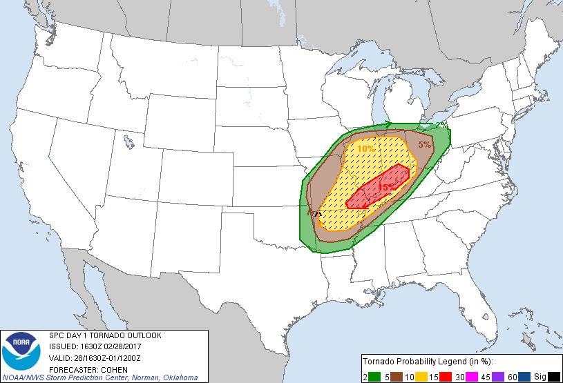
Probabilistic Tornado Graphic

Probability of a tornado within 25 miles of a point.
Hatched Area: 10% or greater probability of EF2 - EF5 tornadoes within 25 miles of a point.
| Day 1 Tornado Risk | Area (sq. mi.) | Area Pop. | Some Larger Population Centers in Risk Area |
|---|---|---|---|
| SIG SEVERE | 155,902 | 18,811,005 | Indianapolis, IN...St. Louis, MO...Cincinnati, OH...Louisville, KY...Springfield, MO... |
| 15 % | 33,529 | 3,247,771 | Louisville, KY...Evansville, IN...Owensboro, KY...Columbus, IN...New Albany, IN... |
| 10 % | 122,417 | 15,600,745 | Indianapolis, IN...St. Louis, MO...Cincinnati, OH...Springfield, MO...Joliet, IL... |
| 5 % | 92,705 | 17,442,966 | Chicago, IL...Columbus, OH...Memphis, TN...Lexington-Fayette, KY...Fort Wayne, IN... |
| 2 % | 85,078 | 12,730,457 | Nashville, TN...Kansas City, MO...Cleveland, OH...Toledo, OH...Akron, OH... |
Probabilistic Damaging Wind Graphic

Probability of damaging thunderstorm winds or wind gusts of 50 knots or higher within 25 miles of a point.
Hatched Area: 10% of greater probability of wind gusts 65 knots or greater within 25 miles of a point.
| Day 1 Wind Risk | Area (sq. mi.) | Area Pop. | Some Larger Population Centers in Risk Area |
|---|---|---|---|
| 30 % | 155,614 | 18,058,954 | Indianapolis, IN...St. Louis, MO...Cincinnati, OH...Louisville, KY...Dayton, OH... |
| 15 % | 138,297 | 22,245,885 | Chicago, IL...Columbus, OH...Memphis, TN...Lexington-Fayette, KY...Fort Wayne, IN... |
| 5 % | 196,437 | 29,636,004 | Nashville, TN...Kansas City, MO...Cleveland, OH...Atlanta, GA...Tulsa, OK... |
Probabilistic Large Hail Graphic

Probability of hail 1" or larger within 25 miles of a point.
Hatched Area: 10% or greater probability of hail 2" or larger within 25 miles of a point.
| Day 1 Hail Risk | Area (sq. mi.) | Area Pop. | Some Larger Population Centers in Risk Area |
|---|---|---|---|
| SIG SEVERE | 166,962 | 19,116,603 | Indianapolis, IN...St. Louis, MO...Cincinnati, OH...Louisville, KY...Dayton, OH... |
| 45 % | 80,093 | 10,232,575 | Indianapolis, IN...St. Louis, MO...Louisville, KY...Springfield, IL...Evansville, IN... |
| 30 % | 86,421 | 8,698,874 | Cincinnati, OH...Dayton, OH...Springfield, MO...Joliet, IL...Peoria, IL... |
| 15 % | 126,708 | 22,450,389 | Chicago, IL...Columbus, OH...Memphis, TN...Lexington-Fayette, KY...Fort Wayne, IN... |
| 5 % | 110,928 | 15,459,540 | Milwaukee, WI...Nashville, TN...Kansas City, MO...Cleveland, OH...Tulsa, OK... |
SPC AC 281630
Day 1 Convective Outlook
NWS Storm Prediction Center Norman OK
1030 AM CST Tue Feb 28 2017
Valid 281630Z - 011200Z
...THERE IS A MODERATE RISK OF SEVERE THUNDERSTORMS ACROSS PORTIONS OF EASTERN MO...CENTRAL/SOUTHERN IL...CENTRAL/SOUTHERN INDIANA...WESTERN/NORTHERN KY...
...THERE IS AN ENHANCED RISK OF SEVERE THUNDERSTORMS SURROUNDING THE MODERATE RISK AREA ACROSS PORTIONS OF THE MO OZARKS TO THE LOWER/MIDDLE OHIO VALLEY REGION...
...THERE IS A SLIGHT RISK OF SEVERE THUNDERSTORMS SURROUNDING THE ENHANCED AREA FROM EASTERN OKLAHOMA AND ARKANSAS TOWARD THE LOWER GREAT LAKES REGION...
...THERE IS A MARGINAL RISK OF SEVERE THUNDERSTORMS SURROUNDING THE SLIGHT ACROSS PARTS OF THE CENTRAL AND EASTERN STATES...
...SUMMARY... Severe thunderstorms are expected to develop from portions of the lower Mississippi Valley to the Ohio Valley through tonight. Strong tornadoes will be possible, especially across portions of the lower and middle Ohio Valley. Otherwise, large hail and damaging winds are expected.
...Portions of the MO Ozarks through the middle MS Valley and the Ohio Valley region...
A prominent warm sector will continue to build northward/northeastward across the region through tonight, as a midlevel speed maximum advances from the southern Rockies east-northeastward toward the Ohio Valley region. As lower/middle 60s dewpoints also develop northward/northeastward, an expansive area of MLCAPE around 500-2000 J/kg -- aided by steep midlevel lapse rates surmounting returning moisture -- will support vigorous convective development. With warm-sector-coinciding effective shear around 40-70 kt, a widespread area of conditional significant-severe potential will exist -- especially from late afternoon into the overnight hours. Present indications are that clusters of storms will be evolving from eastern parts of the central/southern Great Plains northeastward to the vicinity of southern Lake Michigan by late afternoon/early evening in the vicinity of a baroclinic band -- with this activity spreading eastward into tonight. Confidence has increased in more widespread severe-hail potential with this activity, including significant severe hail. Open-warm-sector convection will likely evolve along a low-level jet through parts of the Ohio Valley tonight as additional moistening occurs. Effective SRH of 300-400 m2/s2 will support tornado potential with evolving supercell clusters. This includes the potential for nocturnal significant tornadoes, and tornado probabilities have been increased.
...Portions of the Southeast... Destabilization along the southern/eastern flanks of convection over the TN Valley region may support some increase in convective intensity with storm clusters advancing toward the southern Appalachians. Locally damaging wind gusts may accompany this activity.
..Cohen.. 02/28/2017
CLICK TO GET WUUS01 PTSDY1 PRODUCT
NOTE: THE NEXT DAY 1 OUTLOOK IS SCHEDULED BY 2000Z