Climbing, Hiking & Mountaineering : SummitPost (original) (raw)
Overview
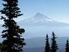
Mount Hood, located about 50 miles east of Portland, Oregon, is one of the most climbed glaciated peaks in North America (#2 in the world behind Japan's Fuji-san, according to some). While it last erupted in 1907 and still has active fumaroles, it is now considered a dormant volcano. Its relatively low altitude (compared to Rainier and Shasta), easy approach, and short hiking/climbing distance (see South Side Route below) makes it much more popular among less experienced climbers. These climbers, lacking experience, and severe weather, which can move in quickly, account for most accidents. Skiers can descend directly from the summit. Dogs are permitted and frequently make the summit.
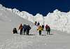
The South Side Route, which begins at the 5,800' Timberline Lodge parking area, is the shortest (< 3 miles) and most popular route to the summit. Above the the Palmer ski lift there are 3 variations of this route, the most popular of which is the Hogsback / Pearly Gates route. The Hogsback / Old Crater variation is used when the Pearly Gates are congested while climbers looking for more of a challenge can use the West Crater Rim variation.
CLIMBING CONSIDERATIONS
- While Mount Hood has reportedly been summited by a woman in high heels, this does not discount the need for climbing experience on this mountain. An ice axe and crampons should be considered mandatory for most climbers, with climbing helmets being a popular addition, especially higher up.
- On warm days it is recommended you get an early start (which is closer to midnight than sunrise), to be out of rockfall areas by 10am.
- Due to the loose rock, climbers are urged to tread lightly, staying on the snow and ice while climbing and not dislodging any rock.
- Check and be wary of the summit cornice, especially during the winter and early spring.
- Do not linger around the fumaroles which create oxygen voids that have asphyxiated (suffocated) unsuspecting climbers.
Routes Overview
Below is a brief routes overview with routes arranged in a counter clockwise order from the south.
Any information regarding filling in this table is highly appreciated. Empty fields indicate unknown or missing information, not that there is no rating or information, e.g. an empty difficulty rating should not automatically be taken to mean an easy route.
Special thanks to Martin Cash for many additions to this table.
| ROUTES OVERVIEW | |||
|---|---|---|---|
| Route Name | Difficulty | Max Angle | Notes |
| Timberline Lodge Approach | |||
| South Side / Hogsback | Class 2 | ~35° | The most popular route on the mountain. |
| Old Crater Variation | Class 2 | ~40° | |
| West Crater Rim | Class 2 | ~40° | |
| Devils Kitchen Headwall (west couloir) | II | ~55° | |
| East Couloir | II | ~55° | |
| Wy'East | III Class 2 | ~50° | |
| Steel Cliff Gullies | III | 50-60° | |
| Cooper Spur Approach | |||
| Newton Clark Glacier | |||
| Elder-Russel Line | IV AI4 5.7 | ||
| Arachnophobia | IV+ AI4 5.9+ | ||
| The Devil's Ramp | III AI3 5.6 | ||
| The Black Spider | III AI3 5.6 | ||
| The Black Widow | IV AI5+ 5.4 A2- | ||
| Cooper Spur | Class 2 | ~50° | Rockfall danger in low snow conditions! |
| North Face | |||
| Northeast Spur | II | ||
| East Gully | III | ||
| East Rib | III | ||
| West Gully | III | ||
| North Cleaver | III | ||
| Elloit Glacier Headwall | II | ~60° | May encounter Class 5 rock in low ice conditions. |
| Sunshine / Coe Glacier Icefall | Class 2 | ~50° | |
| Coe Glacier Headwall | III | 60-65° | |
| East Variation | III | 60-65° | |
| Cathedral Ridge Approach | |||
| Cathedral Ridge | Class 3-4 rock may be encountered. | ||
| Pulpit Rock | |||
| Ladd Headwall | |||
| Illumination Saddle Approach | |||
| Sandy Glacier Headwall | III | ~55° | |
| Yocum Ridge | V Class 5 | ||
| First Gendarme | |||
| Retreat Gully | |||
| Sandy Headwall Traverse | |||
| Sandy Headwall Gully | |||
| Leuthold Couloir | II | ~50° | |
| Reid Glacier Headwall | Class 2 | ~50-60° | |
| Castle Crags | II | Several Class 3 to 5.easy variations. |
Getting There
SOUTH SIDE (AKA TIMBERLINE LODGE) APPROACH: Take US Highway 26 (US-26) towards Government Camp, turning north at the well-signed Timberline Lodge access road about a half-mile east of Government Camp. Follow this well paved road north 5 miles to the Timberline Lodge where year-round skiing and snowboarding (and restaurants) are available. In Portland, you can connect with US-26 East towards Government Camp on I-5 or I-205.
COOPER SPUR APPROACH: Take OR SR-35 to the Polallie Campground (about 20 miles south from Hood River or about 18 miles north from the US-26 / SR-35 junction) and head west on Forest Service Road 3512 to the trailhead at the Tilly Jane Campground, passing the Cooper Spur campground (after which the road is no longer paved). In the winter there is a marked ski trail from the ski area to Cooper Spur, just beyond Tilly Jane.
Red Tape
WILDERNESS PERMIT (MANDATORY): Climbing the summit means entering the Mount Hood Wilderness Area which requires a free, non-quota, self-issued wilderness permit. These are available at the Timberline day lodge "Climbers' Cave" and all trailheads. The Climbers' Cave does not have a door and is thus open year round, 24 x 7.
CLIMBERS' REGISTRATION FORM (OPTIONAL): This is a general form stating the people in your party, planned route, climbing dates and emergency contact info. However, if you don't come back on your stated date, don't depend on this form to initiate a search for you. For South Side routes, this is also available in the Timberline Climbers' Cave.
BLUE BAG(S) (OPTIONAL): Solid bodily wastes are supposed to be disposed of via plastic "blue bags" available at the Timberline Climber's Cave. These are generally not needed on day hikes up the South Side (hold it option ;-). The Climbers' Cave has a 24 x 7 restroom.
EMERGENCY LOCATOR TRANSMITTERS (OPTIONAL): There is a $500 fine if a rescue effort is launched for someone without a cell phone or Mountain Locator Unit (MLU). A MLU allows the county sheriff or rescue groups to pinpoint a climber's exact location which can drastically reduce rescue time and resources. Two things are required for a MLU to work: (1) the lost climber must have it and activate it; (2) the county sheriff must be notified of the lost climber (call 911) to activate their receiving equipment. MLUs are available for rent at the following locations, with only Mount Hood Inn beling local to the mountain:
- Mountain Shop, 1510 NE 37th Ave., Portland, OR (503) 288-6768
- OMC, 2975 NE Sandy Blvd., Portland, OR (503) 227-1038, (800) 538-3604
- REI, 1405 NW Johnson St., Portland, OR (503) 221-1938
- REI, 7410 SW Bridgeport, Tigard, OR (503) 624-8600
When To Climb and Ski
Climbing and skiing on Mount Hood is most popular most from May to Mid-July, which is after avalanche season but before crevasses and rockfall become serious. Climbing is possible during other times of the year, however, use your judgement. The CascadeClimbers.com Oregon Cascades discussion board is a good resource, especially for off season route conditions.
Mountain Conditions
Use the following resources to check route and weather conditions on Mount Hood:
- Summitpost Mount Hood Current Conditions page
- National Weather Service Forecast: Mount Hood, Government Camp
- Mount Hood web cam - Timberline Lodge (free site registration is necessary)
- Government Camp web cam - road conditions
- Northwest Weather and Avalanche Center - Backcountry Avalanche Forecast for Olymics, WA Cascades, and Mount Hood Areas - below 7,000'
- Northwest Weather and Avalanche Center - Mountain Weather Forecast for Olymics, WA Cascades, and Mount Hood Areas
- CascadeClimbers.com - Oregon Cascades Discussion Forum - esp. good for off season info.
- Timberline Mountain Guides (541) 312-9242 - Call or email for current route and conditions info.
Camping
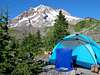
SOUTH SIDE ROUTES: There are three popular places to camp: (1) on the Palmer Glacier above the ski lift generally next to the exposed rocks above the lift but below Crater Rock, (2) in the Timberline Lodge ski area parking lot where tents are not allowed but sleeping in your car is, and (3) in the National Forest below the lodge by taking the first left after turning on to the Timberline access road from US-26. Camping on the summit is also allowed but not all that popular. There are no fees or registration required for any of the options above.
Miscellaneous Info
Here are some useful informational links:
- Chemeketans - a Salem, OR based outdoor activities club
- Mazamas - a Portland, OR based mountaineering club
- Oregon Mountaineering Association
- Portland Mountain Rescue
DMP (Dump Me Please) House Cleaning Effort
This section is for use with the SP House Cleaning effort.
External Links
- Amar Andalkar's Ski Mountaineering and Climbing Site
Routes, photos, links and information about skiing Mount Hood and other peaks. - Leuthold's Couloir trip report
- Mt. Hood summit trip report
- Mount Hood (06/15/2003)
- Mount Hood via South Side (May 1-2, 2003)
- Mount Hood via Hogsback (June 12, 2004)