Fukutoku-Okanoba (original) (raw)
Fukutoku-Okanoba Volcano
Updated: Jan 1, 2025 06:20 GMT - refresh
submarine volcano -14 m / -46 ft
Volcano Islands (Japan), 24.28°N / 141.49°E
Current status: normal or dormant (1 out of 5)
Last update: 13 Oct 2023 (new explosive activity, pumice raft spread to NW)

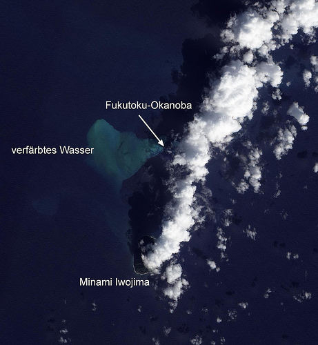
Satellite image of Fukutoku-Okanoa volcano (11 Feb 2010, NASA Earth Observatory)
Fukutoku-Okanoba is a submarine volcano 5 km NE of the small pyramidal island Minami-iwo-jima in the Japanese Volcano Island chain. Eruptions and submarine hydrothermal activity often cause water discoloration in the area, and during eruptions, the volcano has built several temporary new islands. The first observation of a new island was in 1904-05 when it formed Shin-Iwo-jima ("New Sulfur Island"). Small new islands were also formed during the eruptions in 1914 and 1986.
Typical eruption style: explosive
Fukutoku-Okanoba volcano eruptions: 2021, 2010, 2005-07, 1995(?), 1993(?), 1992, 1991(?), 1987(?), 1986, 1976(?), 1974, 1973, 1972(?), 1968(?), 1967(?), 1963(?), 1962(?), 1960(?), 1959(?), 1958(?), 1956(?), 1955(?), 1954(?), 1953(?), 1952(?), 1950(?), 1914, 1904-05
Latest nearby earthquakes
No recent earthquakes
| Time | Mag. / Depth | Distance / Location |
|---|
Background
Fukutoku-Okanoba is part of an elongated submarine volcano with 2 major peaks aligned NNW-SSE, and trachyandesitic in composition, similar to neighboring Iwo-jima volcano.
(Smithsonian / GVP volcano information)
Eruptions of Fukutoku-Okanoba volcano
2010 eruption
An submarine eruption was observed 5 km north-northwest of Iwo Jima Island on 3 February 2010 by the Japanese coast guard. Jets of ash and steam were ejected 100 m above the ocean surface. Since December 2009, the sea water in the area had turned yellow-green.
2005 eruption
A submarine eruption occurred at Fukutoku-Okanoba volcano on 2 July 2005. The water of the sea had turned orange-brown in an area of more than 1 km length.
1992 eruption
A dark plume was observed above Fukutoku-Okanoba by fishing boats on 10 November 1992. An areial survey revealed discolored pale-green water in a narrow fan shape to 10 km NNW from the volcano. Brown pumice was seen floating on the surface.
(Source: Smithsonian / GVP monthly reports)
1986 eruption
An submarine eruption built a new island on 18 January 1986, but the new island had been eroded again by waves and disappeared under the surface by 8 March 1987.
1953 eruption
A submarine eruption was detected on 1 December 1953. Strong smell of sulfur and water discoloration were observed near the volcano.
1950 possible eruption
A possible small submarine eruption took place at Fukutoku volcano on 1 February 1950. Sulfur smell and water discoloration were reported in the area.
1914 eruption
A submarine eruption occurred on January 13, only one day after the great eruption
of Sakura-jima. New submarine explosions created steam and ash clouds of up to 3 km height. Up to 26 explosions per hour occurred on 23 January. On the following days, the eruption was continuous, and a new island, Niijima, emerged on 25 January, which reached a maximum circumference of 8 km and a height of ca. 300 m. It consisted mainly of pumice and obsidian fragments and had a summit crater of 250 m diameter. By February 12, the intensity of the eruptions had decreased, and the island was 0.7-1 km in diameter, 3.5 km in circumference, and a height of 117 m. The island disappeared by April 1916.
---
Sources:
- "CATALOG OF SUBMARINE VOLCANOES AND HYDROLOGICAL PHENOMENA
ASSOCIATED WITH VOLCANIC EVENTS, JANUARY 1,1900 TO DECEMBER 31,1959", WORLD DATA CENTER A (for Solid Earth Geophysics), Report SE-42
- Kuno, H. (1962) "Part XI, Japan, Taiwan and Marianas: Catalogue of the active volcanoes of the world including solfatara fields, International Association of Volcanology", Rome, Italy, 332 p
- Neumann van Padany, M. (1938) "Über die Unterseevulkane der Erde.", De
Mijningenieur, V, Jakarta, Indonesia, Nr 5 - 6 ...more info
1904-1905 submarine eruption and new island
An eruption started in mid June 1904 when explosions were heard and steam and ash clouds observed. A cluster of several new islands formed and merged into the Shin-Iwo-jima ("New Sulfur Island") Island, reaching a diameter of about 4.5 km and a height of about 150 m. The eruption ended or paused in late January 1905.
On 15-16 May 1905 cannon-shot like noises were heard. The size of the island had been reduced significantly by 16 June, measuring only 3 m in height and 450 m in length. By 1 June 1906, the island had disappeared under the water again.
---
Source: Kuno H (1962) "Japan, Taiwan and Marianas. Catalog of Active Volcanoes of the World and Solfatara Fields", Rome, IAVCEI, 11: 1-332
Latest satellite images
Fukutoku-Okanoba Volcano Maps
Below is a selection of maps showing the location and surroundings of the volcano at various resolutions based on aerial-imagery / terrain maps. Feel free to use them for non-commercial purposes on your blog or website as long as you credit them with a link back to this page (click to copy it).
Satellite/aerial-type map of Fukutoku-Okanoba volcano (world scale)
Terrain-type map of Fukutoku-Okanoba volcano (world scale)
Satellite/aerial-type map of Fukutoku-Okanoba volcano (region scale large)
Terrain-type map of Fukutoku-Okanoba volcano (region scale large)
Satellite/aerial-type map of Fukutoku-Okanoba volcano (region scale medium)
Terrain-type map of Fukutoku-Okanoba volcano (region scale medium)
Satellite/aerial-type map of Fukutoku-Okanoba volcano (region scale small)
Terrain-type map of Fukutoku-Okanoba volcano (region scale small)
Satellite/aerial-type map of Fukutoku-Okanoba volcano (local scale large)
Terrain-type map of Fukutoku-Okanoba volcano (local scale large)
Satellite/aerial-type map of Fukutoku-Okanoba volcano (local scale medium)
Terrain-type map of Fukutoku-Okanoba volcano (local scale medium)
Satellite/aerial-type map of Fukutoku-Okanoba volcano (local scale small)
Terrain-type map of Fukutoku-Okanoba volcano (local scale small)
Satellite/aerial-type map of Fukutoku-Okanoba volcano (scale of 10s of km)
Terrain-type map of Fukutoku-Okanoba volcano (scale of 10s of km)
Satellite/aerial-type map of Fukutoku-Okanoba volcano (scale of 20-40 km)
Terrain-type map of Fukutoku-Okanoba volcano (scale of 20-40 km)
Satellite/aerial-type map of Fukutoku-Okanoba volcano (scale of approx. 10-20 km)
Terrain-type map of Fukutoku-Okanoba volcano (scale of approx. 10-20 km)
Satellite/aerial-type map of Fukutoku-Okanoba volcano (scale of 5-10 km)
Satellite/aerial-type map of Fukutoku-Okanoba volcano (scale of few kilometers)
First visit to our site? If you havn't done it yet, download the Volcanoes & Earthquakes app to get one of the fastest volcano news online:
Android | IOS
Try our free app!
Guaranteed tours
= spaces available = guaranteed = few spaces left = booked out

