The Pacific War Online Encyclopedia: Ponape (original) (raw)
|  The Pacific War Online Encyclopedia | |
| -------------------------------------------------------------------------------- | |
The Pacific War Online Encyclopedia | |
| -------------------------------------------------------------------------------- | |
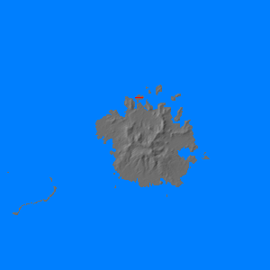
Ponape (158.208E 6.973N) is a relatively large, elevated island in the easternCarolines. Rugged and heavily forested, It is about 19 miles (31 km) in diameter and has a maximum elevation of 2500 feet (760 m). It is surrounded by a reef and has a good anchorage. The Japaneseinvested fairly heavily in the island, and its inhabitants were moderately loyal to the Empire. The island provided hundreds of workers for other islands. By the outbreak of war, Ponape had a seaplanebase, and was protected by a coastal battery and two antiaircraft batteries. The Japanese had completed an airstripby early 1944 on an islet just north of the island capital of Colonia, on the north coast of the main island, and were working on a second airstrip.
On 12 February 1944, six Japanese flying boats staged from Truk through Ponape and managed to destroy the main Marine supply dumps on newly captured Roi-Namur. The Allies responded with strikes by 7 Air Forcefrom Tarawa between 15 and 26 February. The facilities were bombarded by seven battleshipsunder Admiral Leeon 1 May 1944, with air cover was provided by the carriers ofClark's TG 58.1. This was mostly a trainingexercise, as there were few worthwhile targets left on the island and the battle line had never before operated as a unit.
The island was then bypassed by the Alliedcounteroffensive.
References
Morison (1951, 1953)
The Pacific War Online Encyclopedia © 2007, 2009, 2011-2012 by Kent G. Budge. Index
