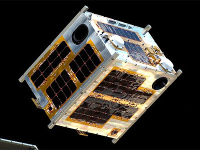
Diwata 1 (original) (raw)

Diwata 1 [NASA]
Diwata 1 is the Philipines' first microsatellite designed, developed, and assembled by Filipino researchers and engineers under the guidance of Japanese experts from Hokkaido University and Tohoku University. The satellite is designed to provide real-time images for disaster risk management and other applications.
The potential uses of Diwata 1 include: improved weather detection and forecasts, disaster risk management, detecting agricultural growth patterns, and the monitoring of forest cover, mining, protection of cultural and historical sites, and the territorial borders of the Philippines.
The 50 kg satellite measures 55 cm × 35 cm × 55 cm. It is powered by body-mounted solar cells.
Diwata 1 carries following payloads:
- a high precision telescope (HPT) with a resolution of 3 meters that can determine the extent of damages from disasters, like typhoons and volcanic eruptions. It can also monitor changes in cultural and natural heritage sites, like the Mount Apo or Mayon Volcano.
- a multispectral imager (SMI) with LCTF to monitor changes in vegetation and monitor oceans productivity. It has a resolution of 80 meters.
- a wide field camera with 7 km resolution to help scientists and weather forecasters better observe cloud patterns and more accurately predict weather disturbances.
- a middle field camera with a resolution of 185 meters assists in determining the locations of images captured using the HPT and SMI.
Diwata 1 was launched in March 2016 onboard of Cygnus CRS-6 to the ISS, were it was deployed later on 27 April 2016 using J-SSOD (JEM Small Satellite Orbital Deployer) from the Japanese JEM (Kibo) module.
Part of the three-year program is the development of a second microsatellite, Diwata 2, to be completed in late 2017 and to be launched in 2018. Compared to Diwata-1, which hosted wide and middle field cameras, Diwata-2 will host enhanced resolution cameras and an amateur radio payload for disaster relief purposes.