Tio Hugo, Rio Grande do Sul (Brazil) (original) (raw)

This page is part of © FOTW Flags Of The World website
Last modified: 2020-08-08 by ian macdonald
Keywords: [rio grande do sul](keywordr.html#rio grande do sul) | [tio hugo](keywordt.html#tio hugo) |
Links: FOTW homepage |search | disclaimer and copyright | write us | mirrors
 image by Ivan Sache, 7 August 2020
- Municipality
- Symbols See also:
- Municipal Flags of Rio Grande do Sul
- State of Rio Grande do Sul
- Brazilian Municipal Flags
- Brazil
Municipality
The municipality of Tio Hugo (2,724 inhabitants in 2010; 11,420 ha) is located 250 km north-west of Porto Alegre.
The municipality of Tio Hugo was established by State Law No. 10,764 promulgated on 16 April 1996, separating from Victor Graeff, Ernestina and Ibirapuit�, and inaugurated on 1 January 2001.
The municipality's odd name (Uncle Hugo) is connected to the building of road BR386, which was completed in 1968. In 1963, Hugo Andr� Loreno established at km 214 a petrol station on behalf of the national company, Petrobr�s. Extremely appreciated by his customers, neighbors and friends, he was nicknamed Uncle Hugo. The town developed by the Rabello company during the building of road 386 was soon named for him.
https://tiohugo.rs.gov.br/
Municipal website
Ivan Sache, 7 August 2020
Symbols
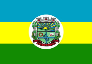
A blue-yellow-green horizontal tricolour with the municipal coat of arms centred in a white oval.
Dirk Sch�nberger, 24 April 2012
Ivan Sache, 7 August 2020