Turvo, Santa Catarina (Brazil) (original) (raw)

This page is part of © FOTW Flags Of The World website
Last modified: 2021-12-11 by ian macdonald
Keywords: [santa catarina](keywords.html#santa catarina) | turvo |
Links: FOTW homepage |search | disclaimer and copyright | write us | mirrors
[ ](../images/b/br-sc-278.gif) image by Dirk Sch�nberger, 20 August 2012
image by Dirk Sch�nberger, 20 August 2012
- Municipality
- Description of the flag See also:
- Santa Catarina
- Municipal Flags of Santa Catarina
- Brazilian Municipal Flags
- Brazil
Municipality
The municipality of Turvo (13,000 inhabitants in 2010; 23,394 ha) is located 250 km south-west of Florian�polis.
Turvo was established by the Italian immigrants Marcos Rovaris and Martinho Guizzo, which were granted big plots by the government as a reward for the construction of roads. In 1912, �ngelo Rovaris acquired from his cousin Marcos a plot near river Turvo, which he soon cleared and planted and cultivated. The two cousins established a flour mill and a sawmill, attracting more colonists. In 1913, Ant�nio Bez Batti, from Urussanga, initiated the clearing of the future site of the municipality. He constructed a road, a shop and a chapel built with local timber.
The district of Turvoa was established within Ararangu� the municipality of Ararangu� by Law No. 1,709 promulgated in 1930, and elevated a municipality in 1948, to be inaugurated on 20 March 1949.
https://www.turvo.sc.gov.br/
Municipal website
Ivan Sache, 8 November 2021
Description of the Flag
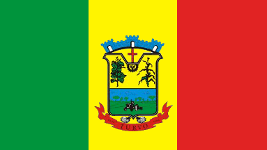
A vertical tricolour, green-yellow-red, with the municipal arms in the centre.
Official website at http://www.turvo.sc.gov.br/home/index.php?
Dirk Sch�nberger, 20 August 2012
Yellow represents resources, referring to the municipality's fertile and resistant soil. Green represents rainforest. Red represents the blood of the colonists who explored the region's forests and lands.
The arms of the municipality of Turvo are composed of a shield surmounted by a mural crown. Placed between the crown and the shield's upper edge, a cross symbolizes people's Christian spirit. The shield is basically divided into two quarters. In the first quarter, in the upper central part, a cogwheel inscribing rice panicles, representing industrialization of this crop as a big source of income for the municipality. Right, a tobacco plant, and left, a maize plant, crops also sources of income for the municipality. In the second quarter a rural landscape, in the foreground a tractor plowing the soil, symbolizing mechanized agriculture in the municipality. In the shield's lower outer part, a scroll inscribed with the municipality's name and date of establishment. Between the shield and the scroll, bananas representing yet another regional crop.
https://www.turvo.sc.gov.br/cms/pagina/ver/codMapaItem/22085
Municipal website
Turvo is officially recognized as Brazil's Capital of Mechanized Agriculture; it ranks Santa Catarina's third bigger rice producer.
The Santa Catarina Tractor Pulling Festival is organized every year in August in Turvo.
https://www.turvo.sc.gov.br/cms/pagina/ver/codMapaItem/22084
Municipal website
Photos
https://www.facebook.com/prefeituradeturvo.sc/photos/233628588696105
https://www.facebook.com/prefeituradeturvo.sc/photos/231322775593353
Ivan Sache, 8 November 2021