Gbarpolu county (Liberia) (original) (raw)

This page is part of © FOTW Flags Of The World website
ꕗꔸꗁꖨ / ㎇arpolu
Last modified: 2013-12-28 by rob raeside
Keywords: gbarpolu | diamond | tree |
Links: FOTW homepage |search | disclaimer and copyright | write us | mirrors
 image by António Martins, 31 August 2008 (source: 2008 stamp)
- Presentation of the county
- Description of the flag
- Variant design on 2008 stamp
- Yellow variant See also:
- Liberian counties
- Liberia
- Clickable map of Liberia External links:
- “Gbarpolu County”, at the English Wikipedia
Presentation of the county
Gbarpolu County was created in 2001, by detaching from Grand Cape Mount County five of its ten districts (Belleh, Bokomu, Bopolu, Gbarma, and Kongba).
António Martins, 31 August 2008
About the flag
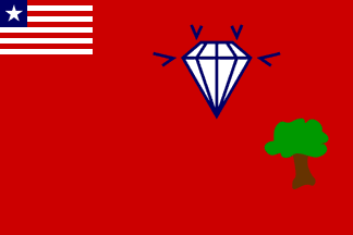
The flag is shown in a 2008 $25 Liberian postage stamp, in a detailed, flat representation. It is a red flag with the usual national flag on the upper hoist (canton) and showing on the upper fly area a white table cut diamond in profile with dark blue (or black) holding lines and brightness ticks (?); at the lower fly a tree in na�ve style, with brown trunk and green canopy.
António Martins, 31 August 2008
Variant design on 2008 stamp
 image by António Martins, 31 August 2008
At this website, the flag image in the $25 2008 stamp seems to use a lighter shade of red for the stripes of the canton, and a darker one for the background; it is also slightly wider than 2:3 and the size of the canton larger than is is usually shown forLiberian county flags.
António Martins, 31 August 2008
Yellow variant
 image located by_Valentin Poposki_, 6 April 2012
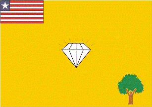
I just found a Gbarpolu county flag on a different color background and a slightly different design on an official document of the Gbarpolu County Development Committee: http://www.emansion.gov.lr/doc/GbarpoluCDA.pdf.
Valentin Poposki, 6 April 2012