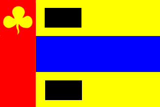
Surhuisterveen (The Netherlands) (original) (raw)

This page is part of © FOTW Flags Of The World website
Achtkarspelen municipality, Fryslân province
Last modified: 2018-12-15 by rob raeside
Keywords: surhuisterveen |
Links: FOTW homepage |search | disclaimer and copyright | write us | mirrors
 Shipmate Flagchart : http://www.flagchart.net
- Surhuisterveen village
- Surhuisterveen Coat of Arms See also:
- Friesland
- Friesland province - the municipalities.
- Achtkarspelen municipality
- Alphabetical index of Dutch municipalities
- The Netherlands - Index of all pages
Surhuisterveen village
Surhuisterveen / Surhústerfean (5740 inh) was founded in the 16th century as a place for peat-diggers and -skippers. Even earlier monks from the monastery Jeruzalem in Gerkesklooster had started the "cultivation", but in 1576 a group of businessmen from Utrecht made a contract with that monastery to dig up the high heath-grounds around Surhuizum. Because of the presence of entrepreneurs Surhuisterveen developed into a regional shopping center.
Surhuisterveen is a "vlecke" (formerly a place with a status between a town and a village), which is why it has a "vlekke-kroon" (townlet-crown). It originated in peat-digging, which is why peat-blocks have been put on flag and Coat of Arms. The village is in the "Friese Wouden" (Frisian forests), which is why there is an acorn on the Coat of Arms. The cloverleaf symbolizes the meadows south of the village. The blue bar and the red pole refer to the canal and the road which meet in the village.
Source: Wapens en vlaggen in de gemeente Achtkarspelen, Buitenpost, 1999.
Surhuisterveen Coat of Arms
[![[Surheusterveen Coat of Arms]](http://www.crwflags.com/fotw/images/n/nl-fr)