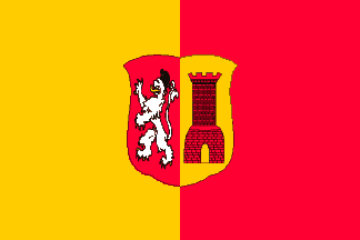
Lichtenvoorde (The Netherlands) (original) (raw)

This page is part of © FOTW Flags Of The World website
Oost Gelre municipality, Gelderland province
Last modified: 2018-12-15 by rob raeside
Keywords: lichtenvoorde |
Links: FOTW homepage |search | disclaimer and copyright | write us | mirrors
 Shipmate Flagchart : http://www.flagchart.net
adopted 30 Oct 1969.
- Lichtenvoorde former municipality See also:
- Gelderland
- Gelderland province - the municipalities
- Oost Gelre municipality
- The Netherlands
- Alphabetical list of Dutch municipalities
- The Netherlands - Index of all pages
Lichtenvoorde former municipality
In 2004 the new municipality of Oost Gelrewas formed by the merger of the former municipalities of Groenloand Lichtenvoorde.
Number of inhabitants (1 Jan 2003): 19.446; area: 73,83 km². Settlements: Lichtenvoorde (seat), Harreveld, Lievelde, Vragender, Zieuwent.
Lichtenvoorde is a municipality in the Achterhoek, East Gelderland. This area was already inhabited 5000 years ago. In the 10the century AD it became a 'heerlijkheid' - 'lordship', which was inherited by the Polish prince Adam Czartorisky, who sold it to Prince Willem V in 1776.
The old flag was divided vertically Yellow - Red and in the center the municipal Coat of Arms, crowned; it was adopted 1958, after it had been used for several years unofficially. The castle on the Coat of Arms reminds of the former castle Lichtenvoorde.
Jarig Bakker, 4 October 1999