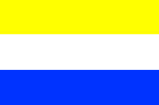
Heerhugowaard [North Holland, Municipality] (The Netherlands) (original) (raw)

This page is part of © FOTW Flags Of The World website
Noord-Holland province
Last modified: 2018-12-15 by rob raeside
Keywords: heerhugiwaard |
Links: FOTW homepage |search | disclaimer and copyright | write us | mirrors
 Shipmate Flagchart : http://www.flagchart.net
adopted 16 Nov 1953
- Heerhugowaard municipality
- Heerhugowaard Coat of Arms See also:
- North Holland
- The Netherlands
- North Holland Province - The municipalities.
- Alphabetical list of Dutch municipalities
- The Netherlands - Index of all pages
Heerhugowaard municipality
Number of inhabitants (1 Jan 2003): 47.313; area: 39,99 km². Settlements: Heerhugowaard (seat), Broekhorn, Butterhuizen, De Noord, Draai, Frik, Kabel, 't Kruis, Veenhuizen, Verlaat.
Heerhugowaard was originally the lake in which Count Willem II was killed in 1256. The lake was made dry in 1625-1631. "Heer Hugo" was Hugo van Assendelft, lord of the castle of Medemblik during the reign of Count Floris V. Heer Hugo was killed when the Westfriezen revolted after the murder of Floris, and destroyed the castle of Medemblik (1296).
Heerhugowaard Coat of Arms
[![[Heerhugowaard Coat of Arms]](http://www.crwflags.com/fotw/images/n/nl-nh)
Granted 8 Dec 1936.