Deventer (Netherlands) (original) (raw)

This page is part of © FOTW Flags Of The World website
Overijssel province
Last modified: 2018-12-15 by rob raeside
Keywords: deventer |
Links: FOTW homepage |search | disclaimer and copyright | write us | mirrors
 Shipmate Flagchart : http://www.flagchart.net
adopted ?
- Deventer municipality
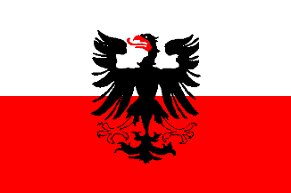
- Deventer old
- Historical flag of Deventer
- Deventer coat of arms
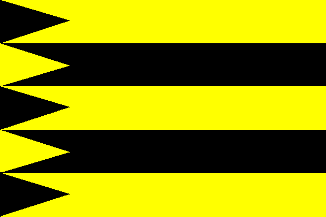
- Diepenveen
- Diepenveen old unofficial flag See also:
- Overijssel
- Overijssel Province - The Municipalities
- The Netherlands
- Alphabetical list of Dutch municipalities
- The Netherlands - Index of all pages
Deventer municipality
Number of inhabitants (1 Jan 2003): 86.084; area: 107,92 km². Settlements: Deventer (seat), Colmschate, Diepenveen, Lettele, Okkenbroek, Schalkhaar.
Deventer is the result of a merger between the former municipalities of Deventer and Diepenveen on 1 Jan 1999, the flag in use is provisional as it is the same as the former municipality of Deventer.
Deventer was an imperial city and was named as such in 1386. The eagle on flag and Coat of Arms is probably the imperial Holy Roman eagle.
Deventer Coat of Arms
[![[Deventer Coat of Arms]](http://www.crwflags.com/fotw/images/n/nl-ov)
Granted 30 Sep 1921
Deventer [former municipality]
 Shipmate Flagchart : http://www.flagchart.net
Historical flag of Deventer
 Shipmate Flagchart : http://www.flagchart.net
Diepenveen [former municipality]
 Shipmate Flagchart : http://www.flagchart.net
Diepenveen old unofficial flag
[![[Diepenveen old unofficial flag]](http://www.crwflags.com/fotw/images/n/nl-ov0di.gif) ](../images/n/nl-ov0di.gif)Shipmate Flagchart : http://www.flagchart.net
](../images/n/nl-ov0di.gif)Shipmate Flagchart : http://www.flagchart.net