Maarssen (The Netherlands) (original) (raw)

This page is part of © FOTW Flags Of The World website
Utrecht province
Last modified: 2018-12-15 by rob raeside
Keywords: maarssen |
Links: FOTW homepage |search | disclaimer and copyright | write us | mirrors
 Shipmate Flagchart : http://www.flagchart.net
adopted 17 Feb 1961
- Maarssen municipality
- Maarssen Coat of Arms Other Maarssen pages:
- Zuilen See also:
- Utrecht Province
- Utrecht Province - The Municipalities
- The Netherlands
- Alphabetical list of Dutch municipalities
- The Netherlands - Index of all pages
Maarssen municipality
Number of inhabitants (1 Jan 2003): 40.599; area: 30,86 km². Settlements: Maarssen (seat), Maarssenbroek, Maarssen-dorp, Maarsseveen, Molenpolder, Oud-Maarsseveen, Oud-Zuilen, Tienhoven.
On 1 Jul 1949 the present municipality was formed by the merger of Maarssen and Maarsseveen.
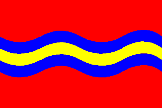
The wavy bar on the flag represents the meandering Vecht river.
Maarssen Coat of Arms
[![[Maarssen Coat of Arms]](http://www.crwflags.com/fotw/images/n/nl-ut)
Granted 3 Jul 1950.