Clickable map of Santarém district (Portugal) (original) (raw)

This page is part of © FOTW Flags Of The World website
Last modified: 2025-05-03 by antónio martins
Keywords: [(no keywords)](keyword%28.html#%28no keywords%29) |
Links: FOTW homepage |search | disclaimer and copyright | write us | mirrors
[⚓︎]
- Clickable map of Santarém district See also:
- Santarém district
- Subdivisions of Portugal
- Clickable map of Portugal
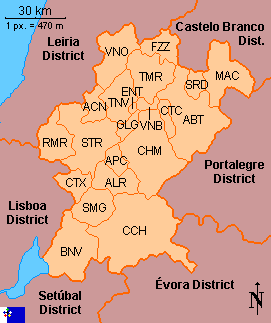 |
Municipalities: ABT Abrantes ACN Alcanena ALR Almeirim APC Alpiarça BNV Benavente CTX Cartaxo CHM Chamusca CTC Constância CCH Coruche ENT Entroncamento FZZ Ferreira do Zêzere GLG Golegã MAC Mação VNO Ourém RMR Rio Maior SMG Salvaterra de Magos STR Santarém SRD Sardoal TMR Tomar TNV Torres Novas VNB Vila Nova da Barquinha |
|---|
Show flag: anchorfloat 
Copyright: FOTW Santarém district map by**António Martinsand boundaries’ data byJarig Bakker**. If you wish to reuse them on your website, read our copyright rules.
[⇞]
Anything below this line was not added by the editor of this page.