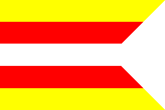
Stupava city, Slovakia (original) (raw)

This page is part of © FOTW Flags Of The World website
Malacky okres, Bratislava region
Last modified: 2018-12-19 by rob raeside
Keywords: stupava |
Links: FOTW homepage |search | disclaimer and copyright | write us | mirrors
 submitted through Rob Raeside, 4 Aug 1999
adopted 1991
- Stupava flag
- Stupava mayor's flag
- Stupava Coat of Arms See also:
- Slovakia
- Slovakian municipal flags
- Malacky okres
- Bratislavský kraj
Stupava flag
Images based on the _Heraldický Register Slovenskej Republiky II, 2001_- Stupava, Malacky district, Bratislava region - adopted 1991, based on a 15th century seal.
Stupava (Hungarian: Stomfa, German: Stampfen had 7834 inhabitants (1990 census). In 1910: 3399 inhabitants (71,5% Slovakians, 11,5% Hungarians and 16,4% Germans). The town was in the Pozsony (Slovakian: Prešporok) County of the Kingdom of Hungary till 1918/1920 (Declaration of Martin / Treaty of Trianon). 1920-1938 part of Czechoslovakia, 1939-1945 part of Slovakia, and 1945-1992 part of Czechoslovakia. Here is the former Pálffy Mansion
István Molnár,21 Jun 2000
Stupava mayor's flag
[![[Stupava mayor's flag]](http://www.crwflags.com/fotw/images/s/sk-ma_st.gif) ](../images/s/sk-ma%5Fst.gif)by István Molnár, 11 Dec 2005, after image on this website.
](../images/s/sk-ma%5Fst.gif)by István Molnár, 11 Dec 2005, after image on this website.
Stupava Coat of Arms
