Clickable map of the Soviet Union (as of 1940-1956) (original) (raw)

This page is part of © FOTW Flags Of The World website
Last modified: 2023-10-07 by antónio martins
Keywords: [(no keywords)](keyword%28.html#%28no keywords%29) |
Links: FOTW homepage |search | disclaimer and copyright | write us | mirrors
[⚓]
See also:
- Soviet subdivisions
- Soviet Union
- Clickable map of Russia
- Clickable map of Asia
- Clickable map of Europe
[⚓]
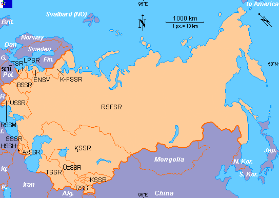 |
AzSSR Azerbaijan BSSR Belarus ENSV Estonia SSSR Georgia HSSH Armenia K-FSSR Karelia KSSR Kyrgyzstan ĶSSR Kazakhstan LPSR Latvia LTSR Lithuania RSFSR Russia RSSM Moldavia RSST Tajikistan TSSR Turkmenistan USSR Ukraine ŬzSSR Uzbekistan |
|---|
Note: No major boundary changes occured from WWII till the fall of the Soviet Union, except for the 1940-1956 RSS status of Karelia.
Show flag: anchorfloat 
Copyright: FOTW Soviet Union map and boundaries’ data by**António Martins**. If you wish to reuse them on your website, read our copyright rules.