Indiana Geography from NETSTATE (original) (raw)
The Geography of Indiana
Click here for a few definitions.
| Longitude / Latitude | Longitude: 84° 49' W to 88° 4' WLatitude: 37° 47' N to 41° 46' N | | | ----------------------------------------------------------------------------------------------------------------------------------------------------------------------------------------- | --------------------------------------------------------------------------------------------------------------------------------------------------------------------------------------------------------------------------------------------------------------------------------------------------------------------------------------------------------------------------------------------------------------- | | | Length x Width | Indiana is 270 miles long and 140 miles wide. | | | Geographic CenterExplanation | Thegeographic center of Indiana is located in Marion County, 14 miles NNW of Indianapolis.Longitude: 86° 16.0'WLatitude: 39° 53.7'N | | | Borders | Indiana is bordered byLake Michigan andMichigan in the north and by Kentucky in the south. On the east is Ohio and on the west isIllinois. | | | Total Area | Indiana covers 36,420 square miles, making it the 38th largest of the50 states. | | | Land Area | 35, 870 square miles of Indiana are land areas. | | | Water Area | 550 square miles of Indiana are covered by water. | | | Highest Point | The highest point in Indiana isHoosier Hill in Franklin Township at 1,257 feet above sea level. | | | Lowest Point | The lowest point in Indiana is 320 feet above sea level, where the Wabash River flows into the Ohio River, in Posey County. | | | Mean Elevation | The Mean Elevation of the state of Indiana is 700 feet above sea level. | | | Major Rivers | Ohio River,Kankakee River,Wabash River, White River,Tippecanoe River | | | Major Lakes | Lake Michigan, Lake Wawasee (Indiana's largest natural lake), Monroe Lake | |
| The Land |
|---|
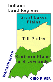
 The smallest state west of the Appalachian Mountains (not counting Hawaii), the landscape of Indiana is influenced by three main land regions; the Great Lakes Plains in the north, the Till Plains in central Indiana and the Southern Plains and Lowlands in the south, the hilliest section of the state.Great Lakes Plains: The Great Lakes Plains is a fertile lowland that runs along the Great Lakes from Wisconsin through Illinois and Indiana to Ohio. AlongLake Michigan, the land is characterized by large sand dunes. To the south of the sand dunes the rich black soil is perfect for Indiana farmers. There are many small lakes and low hills south of the sand dunes. This area is sometimes referred to as the Northern Lake and Moraine Region. Moraines are low hills of earth and rocks left behind by melting glaciers at the end of the ice age. Till Plains: The Till Plains lie to the south of the Great Lakes Plains and run through the center of Indiana. The broad, fertile Till Plains in Indian are a part of the great Midwestern Corn Belt. The landscape of the Till Plains is characterized by low hills and valleys. The highest point in Indiana, Hoosier Hill, is located in Franklin Township in the east. Southern Plains and Lowlands: South of the Till Plains lie the Southern Plains and Lowlands. Ice age glaciers did not advance into this southerly section of Indiana so this area is the hilliest part of the state. "Knobs" are steep hills and this land is characterized by a series of knobs divided by lowlands. It is in this region of Indiana where several caverns, includingMarengo and Wyandotte caves, have been carved in the limestone by underground streams. ( Indiana Close-up ) The smallest state west of the Appalachian Mountains (not counting Hawaii), the landscape of Indiana is influenced by three main land regions; the Great Lakes Plains in the north, the Till Plains in central Indiana and the Southern Plains and Lowlands in the south, the hilliest section of the state.Great Lakes Plains: The Great Lakes Plains is a fertile lowland that runs along the Great Lakes from Wisconsin through Illinois and Indiana to Ohio. AlongLake Michigan, the land is characterized by large sand dunes. To the south of the sand dunes the rich black soil is perfect for Indiana farmers. There are many small lakes and low hills south of the sand dunes. This area is sometimes referred to as the Northern Lake and Moraine Region. Moraines are low hills of earth and rocks left behind by melting glaciers at the end of the ice age. Till Plains: The Till Plains lie to the south of the Great Lakes Plains and run through the center of Indiana. The broad, fertile Till Plains in Indian are a part of the great Midwestern Corn Belt. The landscape of the Till Plains is characterized by low hills and valleys. The highest point in Indiana, Hoosier Hill, is located in Franklin Township in the east. Southern Plains and Lowlands: South of the Till Plains lie the Southern Plains and Lowlands. Ice age glaciers did not advance into this southerly section of Indiana so this area is the hilliest part of the state. "Knobs" are steep hills and this land is characterized by a series of knobs divided by lowlands. It is in this region of Indiana where several caverns, includingMarengo and Wyandotte caves, have been carved in the limestone by underground streams. ( Indiana Close-up ) |
| Climate (All temperatures Fahrenheit) | |
|---|---|
| Highest Temperature | The highest temperature recorded in Indiana is 116°, Fahrenheit. This record high was recorded on July 14, 1936 atCollegeville. |
| Lowest Temperature | The lowest temperature in Indiana, -36°, was recorded on January 19, 1994 at New Whiteland. |
| Average Temperature | Monthly average temperatures range from a high of 88.8 degrees to a low of 15.8 degrees. |
| Climate | Average yearly precipitation for Indiana, from 1971 to 2000, is shown onthis chart from Oregon State University. |
Sources:
The World Almanac of the U.S.A. by Allan Carpenter and Carl Provorse, Copyright © 1998
David L. Anderson and Michael E. Sullivan, "Indiana," World Book Online Americas Edition, http://www.worldbookonline.com/wbol/wbPage/na/ar/co/275040, August 14, 2001.
The United States Geological Survey [Website](http://www.usgs.gov TARGET=)
Maps.com http://www.maps.com
