High Island Texas Bolivar Peninsula. (original) (raw)
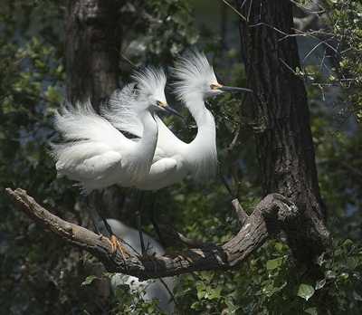
Twin Snowy Egrets at Smith Oaks Rookery, High Island
Photo courtesy Rodger Whatley, April 18, 2006
History in a Pecan Shell
Appropriately named, High Island's altitude of 38-feet makes it the highest point on the Gulf Coast between Mobile, Alabama, and Campeche, Mexico. The name is credited to Anson Jones who referred to the area as "the High Islands" in 1845. Jean Lafitte's cabin boy retired there in the 1870s. His house was restored in the 1970s and he's buried nearby. Naturally, there are rumors of a buried treasure.
The first Anglo settler moved to High Island in 1845. The area didn't gather a population - except when storms hit the coast. A post office wasn't opened until 1897. In the 1890s the the mineral springs were purchased and promoted. The business, which thrived in the late 1890s, was destroyed in the 1900 storm.
An initial search for oil after the Spindletop discovery proved fruitless, but it was finally discovered in the 1930s - providing an economic boost to the region.
Bird Sanctuaries
Today, touism drives the High Island economy with two bird sanctuaries as well as a fishing pier. Book Hotel Here › Galveston Hotels
High Island Related Stories
- Bolivar Peninsula: Scene of Slaving, Smuggling, Filibustering and Farms by By W. T. Block ("Cannonball Tales" Column)
Very few areas of Texas can claim a longer time span of written history than can that thirty-mile sliver of sand known as Bolivar Peninsula... - The Longest Train Ride by C. F. Eckhardt
"Train #1 of the Gulf & Interstate Railroad, left Beaumont, Texas, at 7:00 AM on September 8, 1900, to make the run to Port Bolivar, about 85 miles away by modern highway... G&I #1 was on High Island, within 11 miles of Port Bolivar, when the storm surge came in. When it receded Engine #4 and her tender were buried to the domes in sand, the baggage car had been rolled and tumbled 500 feet across the flats, and the head-end revenue and passenger cars were scattered from Hell to breakfast across the salt marsh. Thirty miles of track had been swept away...
High Island, Texas Forum
Subject: Image from High Island TX
I live in Webster TX. I am a Wildlife/Nature photographer . I took these Twin Snowy Egret's (approx. 5 weeks old) at Smith Oaks Rookery, High Island TX. It's a Wonderful place to share Nature/Wildlife. - Rodger Whatley, April 18, 2006Book Hotel Here › Galveston Hotels
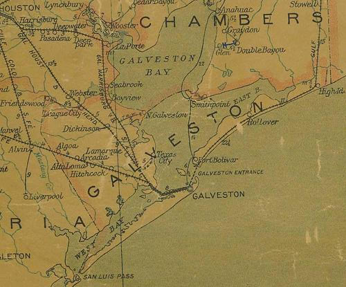
Galveston County 1907 postal map showing High Island
From Texas state map #2090
Courtesy Texas General Land Office
Texas Escapes, in its purpose to preserve historic, endangered and vanishing Texas, asks that anyone wishing to share their local history, stories, landmarks and vintage/historic photos, please contact us.