(no title) (original) (raw)
Three weeks ago it was still winter. I was at the cricket and it was cold and wet and everyone was in winter gear, complete with Crows scarves and beanies cos Cricket Australia doesn't make scarves and beanies. Last week it was spring! We got, like, a solid six days of spring this year. That's a lot of spring because spring is a lie. It's winter up until mid-December, then you get a week of spring, tops, and then BAM you're on day four of 40+ and everything's on fire.
Hey look everything's on fire. Must be summer. IT WAS WINTER THREE WEEKS AGO.

The Advertiser is Helpful. (I mean, they're not wrong. Also lol 'cool in the night' that very night it was still 37 at midnight.)
Mostly, though, fire. I'll just preface all this by saying I'm safe, my family's safe and I promise if I'm ever in a danger zone I'll evacuate (as will be described below) but yes. For now, my bit of the Hills is fine and dandy.
So, fire. NSW has had it shit for ages now, and that's undoubtedly what's been making international news, but we sadly got our bit yesterday. Catastrophic fire conditions (which is the worst) which doesn't necessarily mean something will catch fire, it just means that if something does catch fire it's going to be a shitshow. We've been through plenty of catastrophic days where no catastrophe actually eventuated. Yesterday, manymany things caught fire. Big ones on Yorke Peninsula, in grasslands just off Main North Road, stuff on Kangaroo Island which seems to have been worse today than yesterday, started by dry lightning.
The big one, though, has been the Cudlee Creek fire, which I'd been monitoring all morning, then we went to end of work/pre Christmas lunch at a pub whose aircon was not coping with its fourth day over 40. Those poor waitresses and kitchen staff, omg.
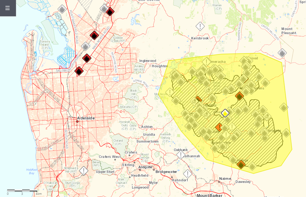
For the record, I live in amongst all those little greyed out <!&rt; marks in the bottom left of those maps. The red indicates the warning area, where you should really be evacuating, and the hasshed-ut bits indicate the fireground. Individual icons indicate reported incidents--exclamation points being small, localised things (like a house alarm, tree down, car accident, that sort of thing), fire is when general nature is on fire and (not visible here, but they'll come in a sec) little houses with fire are buildings on fire.
So that was how it was developing yesterday. Started the top left of that red blob, north-westerly blew it south-east and devouered Lobethal and Woodside, then a cool change hit and brought with it cool winds (it only got to 23 today), fuck-all rain, dry lighting that started the fires on KI and a change in wind direction, so now the goddamn thing looks like this:

Or even more specifically, this. The fireground is the size of Adelaide. Those little pockets there, if you zoom in on Woodside, for example, are where the fieries have managed to keep it back from the actual townships. Yellow means it's downgraded from 'Emergency' status to 'Watch and Act' status, which I'm unclear on because the latest report from the CFS says it's still uncontrolled so idk. Maybe it's just because the conditions aren't nearly so bad as yesterday. Also this from my favourite insta, which is terrifying.
I wish I'd taken a screenie of this before the cloud came over. You could see the plume of smoke on the satelite image from the fire, but I mean... you have to zoom in to see it. Pan west and the shit that's going on in NSW right now is horrifying. If you look at that in daylight (ie not the infra red overnight) then all the dirty-looking cloud cover you can see over half the country is smoke. Cricket match I was watching tonight from Canberra was abandoned because smoke blew over the ground and it looked like this. Victoria is not on fire and yet Melbourne looks like this.
I think WA is okay. They seem to be not on fire. Well done WA!
Oh also, Cudlee Creek was started by a tree falling on power lines. Not fire bugs, thank god.
But yes. In closing, I'm safe. The cool change is now blowing the fire in the complete opposite direction from me (on that map above, I'm around about where the lone greyed out <!&rt; is in the bottom right-ish). It'd have to get through the whole Crafers/Stirling/Bridgewater area, which is much more heavily populated than where it is now and hence much easier for the fieries to navigate by road. It'd also have to jump the freeway, the big red wiggle going through said Crafers/Stirling/Bridgewater area. So yeah, I'm safe and I promise I'll tell you if ever I'm not ♥
'narti originally stuck this at Dreamwidth cos she lives there now.