Contrails reduce daily temperature range (original) (raw)
We analysed maximum and minimum temperature data6 from about 4,000 weather stations throughout the conterminous United States (the 48 states not including Alaska and Hawaii) for the period 1971–2000, and compared these to the conditions that prevailed during the three-day aircraft-grounding period. All sites were inspected for data quality and adjusted for the time of observation.
Because the grounding period commenced after the minimum temperatures had been reached on the morning of 11 September and ended before maximum temperatures were attained on 14 September (at noon, Eastern Standard Time), we staggered the calculation of the average diurnal temperature range (DTR) across adjacent days (for example, 11 September maxima minus 12 September minima). We repeated this procedure for the three-day periods immediately before and after the grounding period, and also for the same periods (8–11, 11–14 and 14–17 September) for each year from 1971 to 2000.
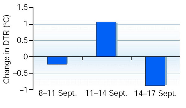
DTRs for 11–14 September 2001 measured at stations across the United States show an increase of about 1.1 °C over normal 1971–2000 values (Fig. 1). This is in contrast to the adjacent three-day periods, when DTR values were near or below the mean (Fig. 1). DTR departures for the grounding period are, on average, 1.8 °C greater than DTR departures for the two adjacent three-day periods.
Figure 1: Departure of average diurnal temperature ranges (DTRs) from the normal values derived from 1971–2000 climatology data for the indicated three-day periods in September 2001.
These periods included the three days before the terrorist attacks of 11 September; the three days immediately afterwards, when aircraft were grounded and there were therefore no contrails; and the subsequent three days.
This increase in DTR is larger than any during the 11–14 September period for the previous 30 years, and is the only increase greater than 2 standard deviations away from the mean DTR (s.d., 0.85 °C). Moreover, the 11–14 September increase in DTR was more than twice the national average for regions of the United States where contrail coverage has previously been reported to be most abundant (such as the midwest, northeast and northwest regions)7.
Day-to-day changes in synoptic atmospheric conditions can affect regional DTRs8. In particular, a lack of cloud cover helps to increase the maximum (and reduce the minimum) temperature. Maps of the daily average outgoing long-wave radiation (OLR)9,[10](/articles/418601a#ref-CR10 " http://www.cdc.noaa.gov
(NOAA-CIRES Climate Diagnostics Center, Boulder, Colorado, USA).") — a proxy for optically thick clouds — show reduced cloudiness (that is, larger OLR) over the eastern half of the United States on 11 September, but more cloud (smaller OLR) over parts of the west. Cloud cover subsequently decreased in the west and increased over much of the eastern half of the country during the next two days, producing predominantly negative three-day OLR changes in the east and positive values in parts of the west.Our findings indicate that the diurnal temperature range averaged across the United States was increased during the aircraft-grounding period, despite large variations in the amount of cloud associated with mobile weather systems (Fig. 2). We argue that the absence of contrails was responsible for the difference between a period of above-normal but unremarkable DTR and the anomalous conditions that were recorded.
Figure 2
NOAA SATELLITE ACTIVE ARCHIVE
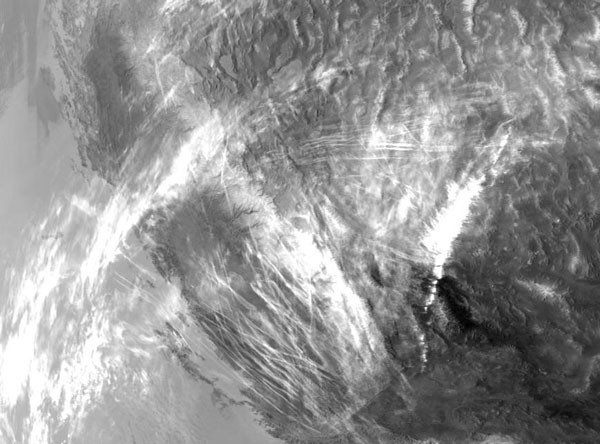
Flight lines: jet contrails can clearly be seen as thin streaks in this satellite image of the southwestern United States.

