Seasonal variability in the global relevance of mountains to satisfy lowland water demand (original) (raw)
1748-9326/19/11/114078
Abstract
Mountain areas play a vital role in global water resources as they often generate disproportionally high runoff and seasonally delay runoff due to storage as snow and ice. Water originating from mountains is used to satisfy human water demand further downstream in the lowlands of the corresponding river basins. Although the relevance of mountains for water supply is widely acknowledged, our current quantitative knowledge of their relevance for human water use on a global scale remains limited to decadal averages. As both water demand and mountain water supply have a strong seasonality, it is crucial to assess the global relevance of mountain areas beyond the annual time scale. To this end, we examined the share of lowland surface water abstraction (LSWA) stemming from mountain runoff in all river basins larger than 10 000 km2 globally from 1990 to 2019, focusing on the intra-annual variability. We distinguished between essential runoff contributions from low and high mountains and potential mountain runoff contributions to LSWA. Essential mountain contributions are defined as the share of water abstractions in the lowlands that can solely be satisfied by mountain runoff, whereas potential mountain contributions are the share that can originate from the mountains but does not necessarily have to. Our results confirm a strong spatial heterogeneity in the contribution of mountain runoff to LSWA. Globally, 15% of annual LSWA can solely be satisfied by mountain runoff, with monthly variations between 9% and 23%, highlighting the strong seasonality in the reliance on mountain runoff for lowland water use. The share of potential mountain contributions is much higher (51% annually). Slightly less than half of the essential mountain contributions to LSWA are sourced from high mountains. This shows the disproportional relevance of these regions, constituting only around one-third of the total mountain area. Furthermore, our results show an increasing dependence of lowlands on mountain runoff contributions.
Export citation and abstractBibTeXRIS
Mountainous areas provide vital goods and services to humanity, have a high biological and cultural diversity and are usually less densely populated than other regions (Adler et al 2022, Thornton et al 2022). These characteristics can be partly attributed to the high slope, relief roughness and elevation, distinguishing mountains from other regions (Kienast et al 2009, Körner et al 2021).
From a hydrological perspective, mountains are often called Earth’s ‘water towers’ (Viviroli et al 2007, 2020, Immerzeel et al 2020). The orographic effect provides mountains typically with disproportionally high precipitation (Barry 2008). In addition, evapotranspiration in the mountains is often lower than in the corresponding lowlands (Viviroli et al 2003) due to their higher elevation (Barry 2008, Goulden et al 2012). Therefore, long-term mean runoff is typically higher than runoff from adjacent lowland areas (Viviroli and Weingartner 2004, Goulden et al 2012), with the highest disproportionalities in arid regions (Viviroli et al 2020). Mountains often have distinct hydrological regimes compared to other areas due to precipitation storage as snow and ice, which delays runoff (Weingartner and Aschwanden 1992, Brunner et al 2020). As mountains are usually located in the upstream parts of river basins, their runoff can be used further downstream for human water use (e.g. Biemans et al 2019, Drenkhan et al 2023).
Human water use includes domestic, industrial, energy, and irrigation. Globally, irrigated agriculture is the largest water consumer, accounting for more than 80% of human-related global water consumption (Döll and Siebert 2002, Brauman et al 2016). Globally, 68% of the area equipped for irrigation is located in regions depending on essential mountain runoff contributions, demonstrating the importance of mountains for human water use and food security (Viviroli et al 2020). Previous studies emphasize the seasonal variability of the contribution of mountain runoff components, namely glacier melt, snowmelt and rainfall, to streamflow (e.g. Buytaert et al 2017, Huss and Hock 2018, Biemans et al 2019). Consequently, the dependence of water abstraction on these streamflow components varies seasonally (Biemans et al 2019, Qin et al 2020).
Biemans et al (2019) assessed the contributions of mountain runoff components to lowland water abstractions and major crop yields in the Indus, Ganges and Brahmaputra basins. The study highlights the spatiotemporal variations in the dependence of lowland water abstraction on mountain runoff, showing that mountain runoff is especially relevant in the pre-monsoon season in the Indus River basin. Lutz et al (2022) extended this analysis into the future using climate and socioeconomic projections, projecting an increase in the importance of meltwater from mountains and groundwater for irrigation. This aligns with the global results from Viviroli et al (2020) who project an increase in the population depending on mountain runoff contributions. Qin et al (2020) estimated the share of irrigation demand met by snowfall globally, highlighting the seasonality in rainfall, snowmelt and irrigation demand which determine the relevance of snowmelt. They find that High Mountain Asia, Central Asia, and Western US especially rely on snowmelt for agricultural water use, confirming results of a previous study on the potential of snow to satisfy human water demand (Mankin et al 2015).
However, snow and glacier melt runoff should not be equated with mountain runoff. The latter encompasses these contributions in mountainous regions but also includes runoff generated by rainfall in mountains (Viviroli et al 2020) and mountain regions without cryospheric influence (Encalada et al 2019).
Few studies have investigated the importance of mountain runoff in a broader sense for satisfying global water demand. Viviroli et al (2020) assessed the potential dependence of lowland population on mountain runoff using a water balance approach, where excess mountain runoff is distributed to the lowlands of the corresponding river basins. Immerzeel et al (2020) developed an indicator that ranks mountain ranges with cryospheric influence according to their role in supplying water to satisfy downstream demand. Both studies do not fully explore the seasonal variability in lowland reliance on mountain runoff. Moreover, previous global studies compare runoff to lowland water demand or consumption to assess the dependence of lowlands on mountain runoff or snow melt, disregarding that runoff is routed through the river system and potentially stored in reservoirs. Thus, the seasonality of water availability is not fully represented. Hence, we lack insight into the seasonal aspects of how lowlands worldwide rely on mountain runoff to satisfy human water demand.
This study adopts a holistic perspective on water originating in mountains and its seasonal usage in lowland areas, beyond the cryosphere, setting it apart from previous research (Mankin et al 2015, Immerzeel et al 2020, Qin et al 2020). We aim to assess the seasonal dependence of lowland surface water abstraction (LSWA) on runoff originating in mountains at a global scale. To this end, we used global hydrological simulations, which include runoff routing. To determine the lower and upper estimates of mountain runoff contributions to LSWA, we used the term ‘essential mountain share’ to define the indispensable requirement for mountain runoff in LSWA and ‘potential mountain share’ for the potential of mountains to supply water for LSWA in addition to the indispensable share. In this way, we aim to improve our understanding of the importance of mountain regions for providing water for human water use in the lowlands. Note that we use the term water abstraction in this study, but the term water withdrawal could be used in the same context.
2.1. Hydrological model and input data
Hydrological simulations were generated with the Community Water Model (CWatM), a grid-based large-scale hydrological and water resources model (Burek et al 2020). The model includes all dominant hydrological storages and fluxes, such as snow, soil, groundwater and river routing. Additionally, it simulates human water abstraction for irrigation, domestic and industrial use and reservoir regulations, aggregated per grid cell. Water is abstracted from water sources in the following order: rivers, lakes and reservoirs, renewable groundwater and non-renewable groundwater. To avoid overestimating water availability for human use, we reduced surface water abstraction (SWA) by the water needed to sustain freshwater ecosystems. Environmental flow requirements (EFRs) were determined using the variable monthly flow method (Pastor et al 2014). For a detailed description of the water abstraction calculations in CWatM, we refer to Supplements S1. For this study, CWatM was coupled with a glacier model (OGGM, Maussion et al 2019) to improve the representation of mountain runoff (Hanus et al 2024). This is a novel advancement in large-scale hydrological modelling of particular relevance for climate change projections (Wiersma et al 2022, Hanus et al 2024). CWatM was used at a 5-arcmin resolution (∼10 km at the equator) to capture relevant elevation differences and distinguish mountain regions.
Numerous global meteorological input data sets with varying quality across regions exist, and it is challenging to identify a single most suitable dataset (Beck et al 2017b, Mazzoleni et al 2019, Fallah and Orth 2020). Here, we used the GSWP3-W5E5 dataset (Cucchi et al 2020) because it is bias-adjusted, and it was also used for the global hydrological simulations of the Inter-Sectoral Impact Model Intercomparison Project (ISIMIP3a). Using bilinear interpolation, we downscaled GSWP3-W5E5 from a 30-arcmin resolution to 5-arcmin with WorldClim v2.1 (Fick and Hijmans 2017). CWatM requires additional input data, e.g. a flow direction map, information on the land cover type, water demand, and soil and groundwater characteristics, for which the global maps described in Burek et al (2020) were used. Calibration in global hydrological studies remains a challenge to date (Yoshida et al 2022). Therefore, we show results as the median values of simulations based on five parameter sets. We used five previously generated parameter sets (Hanus et al 2024), including the one used for the ISIMIP3 simulations of CWatM, which were calibrated similarly to Greve et al (2023). The model was run with a daily timestep from 1990 to 2019 after being initialized using a spinup period of 5 times 30 years to ensure that the hydrological model’s slowly responding components, such as the groundwater storage, lakes, and reservoirs, were in equilibrium with the past climatic conditions.
2.2. Mountain delineation
A crucial step in this study was to differentiate mountain areas from non-mountain areas, hereafter called lowland areas. For global applications, there are four commonly used mountain delineation approaches (Kapos et al 2000, Meybeck et al 2001, Körner et al 2011, Karagulle et al 2017). These are based on slope, relief roughness, elevation or a combination thereof, primarily varying in the degree to which lower mountains are included (Körner et al 2021). Following these definitions, mountains cover 12%, 25%, 26%, and 30% of the land mass outside Antarctica, respectively (Meybeck et al 2001, Sayre et al 2018). Accordingly, the population estimated to live in mountain areas varies between 5% and 31% (Thornton et al 2022). For an in-depth comparison and definition of mountain delineations, we refer to Sayre et al (2018) and Körner et al (2021) and the Supplements S3. The global study of Viviroli et al (2020) used an adapted version of the mountain delineation by Meybeck et al (2001) to also include hills, resulting in 39% of the land area outside Antarctica and Greenland being categorized as mountainous.
For this study, we used the mountain delineation by Karagulle et al (2017) to distinguish mountains as landforms independent of their elevation and differentiate between high mountains and mountains in a broader sense. This mountain delineation differentiates between low and high mountains using the local relief, which cover 19% and 11% of the land mass, respectively (Sayre et al 2018). For comparison, results using the most stringent mountain delineation (Körner et al 2011) are shown in the Supplements S6.
2.3. River basin selection
River basins were delineated using the drainage direction map used by CWatM (Eilander et al 2021), based on the digital elevation model by Yamazaki et al (2019). River basins were defined as areas where no downstream grid cell could be found, meaning that the river basins either drain into the sea or are endorheic basins. To represent the hydrological connectivity of river basins to deltas areas, 48 major deltas (Tessler et al 2015) were connected to the corresponding river basins. We selected river basins with an area larger than 10 000 km2 because smaller river basins are likely not well represented by CWatM at a 5-arcmin resolution. This resulted in 892 river basins with lowlands and mountains, while 318 basins only constituted lowlands. The basin areas range from 10 000 km2 to 6,8 Mio. km2. Together, these basins cover 81% of the global land area outside Antarctica and Greenland, and 30% of this area is mountainous.
2.4. Simulation analysis
Four different simulations were needed to determine the mountain runoff contribution to lowland surface water abstraction (LSWA), similar to the method used by Biemans et al (2019). The simulations differ in the inclusion of water resources from lowlands, low and high mountains (table 1). Thus, the simulated lowland surface water abstraction volumes, which were summed up over the lowland areas within each river basin, differed between the simulations.
Table 1. Water sources and demands included in the simulations used to determine the mountain runoff contributions to LSWA (table 2). Abbreviations in italics refer to the different simulations. all: all water resources; lld: lowland water sources; lld_lowmnt lowland and low mountain water resources; mnt mountain water resources.
| | all | lld | lld_lowmnt | mnt | | | --------------------------------- | ----- | ------------- | ----- | - | | water resources of lowlands | x | x | x | | | water demand of lowlands | x | x | x | x | | water resources of low mountains | x | | x | x | | water resources of high mountains | x | | | x | | water demand of low mountains | x | | x | x | | water demand of high mountains | x | | | x |
Comparing these LSWA volumes yielded the share of LSWA that needs to stem from mountains (‘essential mountain share’) and the share of LSWA that mountain runoff could satisfy additionally, called ‘potential mountain share’ (table 2). The sum of both shares represents the maximum potential of mountains to supply water for lowland abstraction. The remaining LSWA relies on water from the lowlands (‘essential lowland share’). The essential mountain share was further differentiated into essential low and high mountain share.
Table 2. Origins of surface water abstracted in lowlands (LSWA) that were differentiated in this study using different simulations as described in section 2.4. The calculation method describes how the respective shares were determined by comparing simulated LSWA volumes from different simulations, aggregated per river basin. Abbreviations in italics refer to the different simulations (table 1).
| Origin of LSWA | Definition | LSWA calculation |
|---|---|---|
| Essential mountain share | Share that needs to stem from mountains | all - lld |
| Essential high mountain share | Share that needs to stem from high mountains | all - lld_lowmnt |
| Essential low mountain share | Share that needs to stem from low mountains | Essential mountain share - Essential high mountain share |
| Potential mountain share | Share that can originate from mountains or from lowlands themselves | mnt - Essential mountain share |
| Essential lowland share | Share that needs to stem from lowlands themselves | all - mnt |
Relative and absolute mountain runoff contributions to surface water abstraction were derived for different time scales: 30 year annual average, 30 year monthly averages, and annual averages. Results were spatially aggregated over the Northern and Southern Hemisphere and by major climate zones of the lowlands (Peel et al 2007). Trends over the simulation period were analyzed using the Mann–Kendall trend test, while trend strength was assessed using Sen’s slope estimator. To analyze the seasonality, we derived two metrics using circular statistics, which describe the shape of the seasonal distribution of the different contributions to LSWA in each river basin (e.g. Young et al 2000, Blöschl et al 2017). The center of gravity of each contribution’s seasonal distribution represents the average timing of this contribution, whereas the concentration of the seasonal distribution reflects the spread around this timing. For detailed information see Supplements S2.
3.1. Spatial heterogeneity in lowland dependency on mountain runoff
River basins originating in the large mountain ranges of the world (Himalayas, Andes, Rocky Mountains), as well as river basins in the Mediterranean, South and Eastern Asia, India and the Middle East, show high long-term average essential mountain runoff contributions to LSWA, meaning that a high percentage of LSWA needs to originate from mountain runoff (figure 1). Combining this with the basins’ LSWA magnitude revealed regions where mountain runoff plays a crucial role as lowland water use is high. These are located in Western North America (Columbia, Sacramento, San Joaquin), Western Andes (Rapel), Southern Europe (Ebro), the European Alps (Po), the Himalayas (Indus, Syr Darya), the Middle East (Shatt al-Arab, Kura) and Southeast and East Asia (Chao Phraya, Red and Yellow River). More than 25% of the LSWA in these river basins must originate from mountain runoff. Globally, in 33% of all mountain-covered river basins, more than 10% of LSWA needs to stem from mountain runoff (more than 25% in 21% of basins), whereas, in 46% of the basins, mountains need to provide less than 1% of LSWA (e.g. Amazon, Lena).
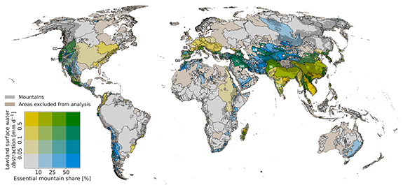
Figure 1. Lowland surface water abstraction per unit area and essential mountain runoff share in this abstraction in 892 river basins worldwide. Green colors indicate basins where mountain runoff plays a crucial role, as both the essential mountain runoff share and the lowland surface water abstractions themselves are high. The dotted area shows the simplified version of the mountains’ extent. The brown color displays river basins that were excluded from the analysis. They are either smaller than 10 000 km2 or do not hold both, mountains and lowland water abstraction. Results are derived as the median of five simulations. Letters refer to basins shown in figure 3.
Download figure:
Standard imageHigh-resolution image
3.2. Strong seasonality in lowland dependency on mountain runoff
Lowlands rely on mountain runoff contributions for surface water abstraction, especially in the summer months when water abstraction is highest (figures 2–4). In the river basins, the essential contributions to LSWA are generally more concentrated in the year than the potential mountain contributions and total LSWA, proposing that runoff originating specifically from mountains, but also from lowlands, is indispensable in particular months, especially runoff contributions from high mountains (figure 2(b)). For example, the seasonal concentration in the essential runoff contribution of high mountains is above 0.4 in 88% of the river basins. In contrast, this is only the case for around 40% of the basins for the total LSWA and potential mountain runoff contributions (figure 2(b)). The concentrations vary largely across river basins, underlining the heterogeneity between river basins. The average timing of the total LSWA is similar across river basins, while the average timing of contributions varies more, with the largest variability for the potential mountain share (figure 2(a)).
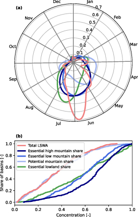
Figure 2. Seasonal distribution metrics of the absolute contributions to LSWA (cf table 2) and total LSWA in river basins in the Northern Hemisphere. (a) Distribution of the position of the centers of gravity representing the average timing (_y_-axis represents density) and (b) cumulative distribution function of the concentration of the seasonal distributions, representing the spread around the average timing. Distributions are based on river basins with maximum monthly relative essential mountain contribution larger than 10% (342 basins). Results are derived as the median of five simulations.
Download figure:
Standard imageHigh-resolution image
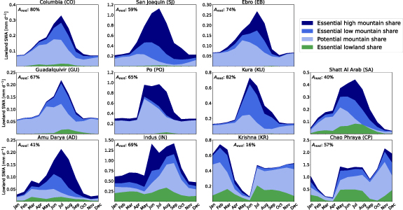
Figure 3. Average monthly lowland surface water abstraction and its shares (cf table 2) in selected river basins with a high share of mountain runoff in LSWA and high LSWA in North America, Europe, Middle East, High Mountain Asia, South and Southeast Asia. For the location of the river basins see figure 1. Additionally, the fraction of mountains in the basin (_A_mnt) is shown. Results are derived as the median of five simulations.
Download figure:
Standard imageHigh-resolution image
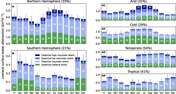
Figure 4. Average monthly lowland surface water abstraction and its shares (cf table 2) aggregated over all river basins larger than 10 000 km2 in the entire Northern Hemisphere (A) and distinguished by major lowland climate zones (Peel et al 2007, A1–A4), as well as the Southern Hemisphere (B). Note the different _y_-axis scales. Error bars show the variation in lowland surface water abstraction from 1990 to 2019. Numbers in the bars indicate percentage contributions and numbers in the title indicate the share of mountain area in all river basins combined. Global percentage contributions are similar to those in the Northern Hemisphere (figure S12). Results are derived as the median of five simulations.
Download figure:
Standard imageHigh-resolution image
Whereas the centers of gravity of the seasonal distribution of LSWA and its essential low mountain contributions occur concurrently, the essential high mountain and lowland contributions occur mostly later (figure 2(a)). Conversely, the seasonal distributions of potential mountain contributions are shifted towards earlier in the year. This is confirmed by river basins with high contributions of mountain runoff in LSWA, for which the essential mountain runoff contributions peak in July, whereas the potential mountain runoff contributions peak earlier (San Joaquin, Po, Ebro, Shatt al-Arab and Amu Darya, figure 3). Thus, the reliance on mountain runoff increases in summer in these basins. Earlier in the year, the lowlands can provide a substantial fraction of surface water abstractions (figure 3). This pattern is inverted in the Indus River basin, and the reliance on mountain runoff is most prominent in the pre-monsoon season. Whereas in some river basins with high reliance on mountain runoff, mountains could satisfy all lowland surface water abstraction throughout the year (e.g. Ebro, Kura, Po, San Joaquin), other river basins rely on lowland runoff in addition to mountain runoff (e.g. Indus, Shatt al-Arab, Chao Phraya, Krishna, Amu Darya) (figure 3).
3.3. Globally large potential of mountains to contribute to lowland water abstraction
Globally, 15% of lowland surface water abstractions depend essentially on mountain runoff, meaning they cannot be satisfied by lowland runoff itself. An additional 51% could be satisfied by mountain runoff, indicating that the potential of mountain runoff to contribute to lowland water abstractions exceeds current needs (figure 4). 33% of lowland surface water abstraction needs to stem from lowland runoff. Seasonal variations range from 9% essential mountain runoff contributions to LSWA in October to 23% in May in the Northern Hemisphere, illustrating the strong seasonal dependence of lowland surface water abstraction on mountain runoff. This dependence is highest in arid lowlands, where essential mountain runoff contributions to LSWA reach 43% in June, whereas it is lowest in cold lowlands (figure 4). The sum of potential and essential mountain contributions globally exceeds 55% in all months. Thus, more than half of the global LSWA does not need to stem from the lowlands themselves but can be supplied by mountain runoff, showing the large potential of mountains to contribute to lowland water abstraction.
3.4. Disproportional importance of high mountains
Globally, slightly less than half of the essential mountain runoff contributions are attributed to high mountains (figures 4 and 5), although high mountains only cover a third of the total mountain area. Hence, high mountains are disproportionally important for providing runoff which is required for lowland water abstraction. While the essential runoff contributions from high mountains constitute more than half of the essential mountain contributions in arid basins, low mountains contribute more than half in tropical and cold basins. The importance of low and high mountains varies greatly between river basins (figure 3). In the Po basin, runoff from high mountains dominates the essential mountain runoff share in LSWA, while runoff from low mountains does so in the Guadalquivir and Kura basins.
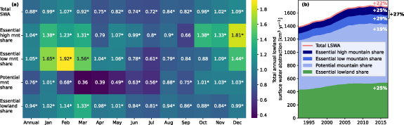
Figure 5. (a) The 30-year trend in annual and monthly lowland surface water abstraction and its contributions (cf table 2) from mountains and lowlands aggregated over all river basins larger than 10 000 km2. Numbers indicate the median relative increase [%] calculated with the Sen’s slope estimator, * indicates significant trends for all parameter sets (_p_-values 0.05). (b) shows the median annual LSWA differentiated by its contributions from 1990–2019, smoothened by a 5-year window. Numbers show the relative increase in each contribution of the period 2015–2019 compared to 1990–1994. Total essential mountain contributions increased by 29% and total LSWA increased by 22%.
Download figure:
Standard imageHigh-resolution image
3.5. Increasing reliance of lowlands on mountain runoff for water abstraction
Lowland surface water abstraction has significantly increased globally from 1990 to 2019. Consequently, its contributions from lowlands and mountains have increased (figure 5). The relative annual trend is strongest for the essential share of low and high mountains (1.05% and 1.04%, respectively), followed by the essential lowland share (0.94%). This is reflected in a 27% increase in essential mountain contributions during the study period, compared to a 25% increase in essential lowland contributions and 22% increase in total LSWA. Thus, lowlands increasingly rely on mountain runoff as the total abstractions increase. In months with the largest LSWA (June–August), especially abstraction contributions from high mountains and the lowlands increase. In months with the highest increase in global LSWA (November–March), the essential contributions from low and high mountains have the strongest increasing trend.
4.1. Key factors in lowland dependence on mountain runoff
Mountains receive disproportionally high precipitation and lose less water through evapotranspiration than the downstream lowlands, especially in arid regions (Viviroli et al 2003, Goulden et al 2012). Therefore, mountain runoff is more relevant for human water use in arid lowlands (figure 4). We examined different explanatory variables for the essential mountain runoff contribution to LSWA using random forest feature importance and _k_-means clustering. We found that the combination of lowland demand, the connectivity to mountains and the disproportionality of the mountain water supply determine the essential mountain runoff share in lowland water use. Nevertheless, it was unfeasible to rank these factors or group basins by governing factors due to their interactions and the spatial variability in water demand and supply within the lowlands of different river basins. For example, our results highlight the Po River basin as the basin originating from the European Alps with the highest dependence on mountain runoff for lowland water abstraction. The governing factors favor a higher mountain contribution than the adjacent river basins (table S6).
Using a more stringent mountain delineation (Körner et al 2011) reduces the essential runoff contributions of mountains to LSWA. Since mountains only constitute 12% instead of 30% of global land area, the annual essential mountain contributions to LSWA are reduced from 15% globally to 7% (figure S21). However, the essential mountain runoff share relative to the mountain area is larger for the stringent mountain delineation (figure S22). The essential contributions from overall mountain runoff using the stringent mountain delineation are similar to the essential contributions from high mountain runoff of the broader mountain delineation by Karagulle et al (2017) because of their similarity in their extent. Thus, the mountain delineation used in the analysis affects how strongly lowlands rely on mountain runoff for water use.
4.2. Seasonal significance of mountain contributions
Mountain runoff is essential for lowland water use in many world regions. Using mountain runoff can prevent overexploiting local water resources at lowland water abstraction locations, such as groundwater. The relevance of mountain runoff for lowland water use is more pronounced in individual months than annually due to the high seasonality of lowland water demand (cf figures 3 and 4). Essential mountain runoff contributions constitute up to 23% of LSWA in a month compared to 15% annually. High water demand in the summer or dry months often coincides with low water availability from the lowlands (Bandyopadhyay et al 1997), increasing the necessity of mountain water usage. After the peak in LSWA, towards late summer, the essential lowland contributions become more relevant in the river basins (figure 2), likely due to lower water availability from mountains. 30% of the world’s population lives in the lowlands of river basins where the maximum monthly essential mountain runoff contribution constitutes at least 20% of monthly surface water abstractions (population data from Klein Goldewijk et al 2017). Yet only 10% of the population lives in lowlands where the annual essential mountain runoff share to LSWA exceeds 20%. This stresses the seasonal dependency of lowland water abstraction, and thus lowland population, on mountain runoff.
Additionally, our study assesses the potential of mountains to satisfy lowland demand. Globally, this potential exceeds three times the essential mountain contributions (see figure 4). Consequently, mountains can satisfy increasing water demand (cf figure 5), which is important for projected future water demand increase (Viviroli et al 2020). As water demand increases, the pressure on water resources increases, leading to less flexibility in sourcing surface water from mountains or lowlands. This is reflected in the relatively smaller increase in potential mountain share compared to other contributions in the study period (see figure 5). Consequently, reliance on specific sources, particularly mountains, has increased. The reason is likely that lowlands more frequently reach their maximum water supply capacity, which leads to a greater reliance on mountain runoff because mountains typically generate a higher runoff per unit area than lowlands.
Lowland and mountain water availability are expected to change due to climate change with major impacts on discharge seasonality (Arnell and Gosling 2013, Brunner et al 2020). Glacier-sourced melt contributions to streamflow are projected to decrease in most river basins (Huss and Hock 2018, Hanus et al 2024) towards the end of the century. Moreover, the snowfall fraction is projected to decrease with increasing temperature, with larger impacts at low and mid elevations due to its non-linearity in temperature sensitivity (Marty et al 2017, Gottlieb and Mankin 2024), impacting streamflow seasonality (Siirila-Woodburn et al 2021, Gordon et al 2022, Han et al 2024). Mountain runoff will be more affected by these changes than lowland runoff, as snow and glaciers are more abundant in the mountains than in the adjacent lowlands. Also, future streamflow is dependent on changes in evapotranspiration, which will probably lead to decreasing runoff from mountains (Goulden and Bales 2014, Milly and Dunne 2020). Hence, future research should focus on assessing the future seasonal dependence of lowland water abstractions on mountain runoff.
4.3. Comparison to previous studies
Different mountain delineations and methodologies complicate the comparison of results to previous studies. This study explicitly incorporated the connectedness of mountains to the lowlands for water abstraction and summarized results at the river basin scale. In contrast, Viviroli et al (2020) give a broad overview of the relevance of mountain runoff for human water use where excess mountain runoff is used anywhere in the lowlands, whereas Immerzeel et al (2020) analyze mountain runoff relevance in connected downstream areas.
Regardless, High Mountain Asia and Shatt al-Arab are consistently identified as hotspot regions (Mankin et al 2015, Immerzeel et al 2020, Qin et al 2020, Viviroli et al 2020). River basins in High Mountain Asia have been extensively investigated due to the clear upstream-downstream connectivity of mountains and lowlands and large water demands in the lowlands (Wijngaard et al 2018, Armstrong et al 2019, Lutz et al 2022, Yao et al 2022). Similar to previous studies, our results show a high dependence of the Indus River basin on mountain runoff. In contrast, the Ganges-Brahmaputra basin has high water abstraction, but mountain runoff only plays a minor role (Mankin et al 2015, Biemans et al 2019, Immerzeel et al 2020).
Similar to Viviroli et al (2020), our results show high relevance of mountain runoff for LSWA in river basins in southern Spain, southern India, and the Chao Phraya river basin. However, this relevance is not captured in other previous studies (Mankin et al 2015, Immerzeel et al 2020, Qin et al 2020) because the mountains of these river basins are not part of the cryosphere. These results stress that mountains that act as ‘water towers’ do not need to be cryospheric.
Our results do not capture the relevance of mountain runoff for human water use in the Nile and Niger river basins, as stressed by Viviroli et al (2020), because simulated discharge was largely overestimated for the White Nile. Consequently, the relevance of discharge from the Blue Nile, including mountain runoff from the Ethiopian Highlands, for the downstream water abstraction was considerably underestimated. The discharge overestimation in the White Nile is likely due to the lack of proper representation of dynamic wetlands and their enhanced evapotranspiration, such as the Sudd wetlands in South Sudan. This is a known issue in global hydrological modelling (Bierkens 2015) and one of the factors resulting in a discharge overestimation in arid and semi-arid regions in global hydrological models. It consequently leads to underestimating the relevance of mountain runoff in the respective river basins. Additionally, the mountain delineation used here classifies less area as mountainous in the Nile and Niger River basins compared to Viviroli et al (2020), and thus findings on the reliance on mountain runoff are not directly comparable.
4.4. Lower limit of essential mountain contributions
This global study provides an extensive overview of the seasonality of lowlands’ dependence on mountain runoff in different regions. However, we acknowledge that such global studies can only provide limited information on specific river basins. Furthermore, the spatial scale of our simulations is insufficient for detecting the reliance of relatively small river basins on mountain runoff, such as the Rio Santa (Buytaert et al 2017, Milner et al 2017). Global hydrological models frequently overestimate discharge (Zaherpour et al 2018, Heinicke et al 2024), especially in arid regions (Bierkens 2015, Beck et al 2017a, Heinicke et al 2024), which is also the case for this study. Thus, our results should be understood as a lower limit of essential mountain runoff share to lowland abstractions as water availability in the arid lowlands is likely overestimated. Moreover, inner-basin transfers are only simplistically represented, while interbasin transfers are not implemented. For example, the diversion of water from the Amu Darya river basin westwards towards the Caspian Sea and, hence, the dependence of these regions on mountain runoff is not represented. Also, the simplified inner-basin transfer is likely insufficient to represent the extensive irrigation systems in the Indus River basin. Consequently, mountain runoff relevance for human water use in lowlands is likely underestimated. We focus on surface water abstraction as the connectedness between mountain groundwater recharge and lowland groundwater aquifers remains unknown. However, lowland groundwater might partly stem from mountain areas (van Tiel et al 2024). Hence, mountains might be relevant for lowland water supply beyond surface water abstractions. Using a basin perspective, we summarize results into hydrologically relevant spatial units in this study. However, mountain runoff contribution differences within the lowlands are averaged out, thus neglecting the heterogeneity within basins (Gordon et al 2024). Moreover, not all lowland areas are hydrologically connected to the mountains, such as in the Mississippi basin. This reduces the potential of mountains to supply water to the lowlands of the basins. Thus, the mountain runoff contributions to lowland water abstraction would be higher when only considering the connected lowlands similar to Immerzeel et al (2020).
We isolated the monthly contribution of mountains to lowland surface water abstractions (LSWA) at a global scale, considering the routing of runoff and mountains beyond cryospheric influence. Hereby, we distinguished between the share of LSWA that needs to stem from mountains and the share of LSWA that can stem from mountains, but does not necessarily have to, namely the essential and potential mountain runoff contributions. We found that globally, the potential mountain runoff contributions to LSWA (51%) were more than three times higher than the essential mountain runoff contributions (15%) for long-term averages. Thus, mountains can satisfy the past increasing lowland water demand, which results in an increasing dependence on mountain runoff. Our results highlight a strong seasonality in the relevance of mountain runoff for lowland water use, reflected in monthly varying essential mountain runoff contributions from 9% to 23% in global LSWA. In arid lowlands, the essential mountain share to LSWA reached 43% for one month and 31% on annual averages. This underlines the relevance of the climatic conditions in the lowlands for assessing the importance of mountain contributions. Furthermore, our results show that high and low mountains contribute a similar essential runoff share to lowland water abstraction, although high mountains only amount to around one-third of the mountain area. This emphasizes the relevance of high mountains for lowland water use. On the other hand, it shows the substantial role that low mountains play in water provision. Together with results from individual river basins, this demonstrates the relevance of mountains for human water supply beyond high mountains with cryospheric influence.
Part of the research was developed in the Young Scientists Summer Program at the International Institute for Applied Systems Analysis, Laxenburg (Austria) with financial support from the GRC Travel Grant of the University of Zurich. We thank the reviewers for their valuable input.
The data that support the findings of this study are openly available at the following URL/DOI: https://doi.org/10.5281/zenodo.13354811.