Bruce Houghton - Profile on Academia.edu (original) (raw)
Papers by Bruce Houghton
Fact Sheet, 2011
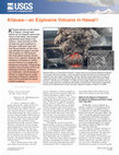
Kïlauea Volcano, on the Island of Hawai'i, is best known for its frequent sustained eruptions of ... more Kïlauea Volcano, on the Island of Hawai'i, is best known for its frequent sustained eruptions of lava flows and lava fountains, which are gentle enough that they can be observed and enjoyed from close range. Occasionally, however, Kïlauea erupts explosively, hurling out rocks and plumes of fine pulverized material. Several small explosions occurred in 2008 and 2011, like this one on October 12, 2008, but much larger explosive eruptions have occurred in past centuries, sometimes with deadly consequences. Inset shows a large block thrown out of Halema'uma'u Crater during an explosive eruption on March 19, 2008.
Natural Hazards, 2006
The devastating southeast Asian tsunami of December 26, 2004 has brought home the destructive con... more The devastating southeast Asian tsunami of December 26, 2004 has brought home the destructive consequences of coastal hazards in an absence of effective warning systems. Since the 1946 tsunami that destroyed much of Hilo, Hawai'i, a network of pole mounted sirens has been used to provide an early public alert of future tsunamis. However, studies in the 1960s showed that understanding of the meaning of siren soundings was very low and that ambiguity in understanding had contributed to fatalities in the 1960 tsunami that again destroyed much of Hilo. The Hawaiian public has since been exposed to monthly tests of the sirens for more than 25 years and descriptions of the system have been widely published in telephone books for at least 45 years. However, currently there remains some uncertainty in the level of public understanding of the sirens and their implications for behavioral response. Here, we show from recent surveys of Hawai'i residents that awareness of the siren tests and test frequency is high, but these factors do not equate with increased understanding of the meaning of the siren, which remains disturbingly low (13%). Furthermore, the length of time people have lived in Hawai'i is not correlated systematically with understanding of the meaning of the sirens. An additional issue is that warning times for tsunamis generated locally in Hawai'i will be of the order of minutes to tens of minutes and limit the immediate utility of the sirens. Natural warning signs of such tsunamis may provide the earliest warning to residents. Analysis of a survey subgroup from Hilo suggests that awareness of natural signs is only moderate, and a majority may expect notification via alerts provided by official sources. We conclude that a major change is needed in tsunami education, even in Hawai'i, to increase public understanding of, and effective response to, both future official alerts and natural warning signs of future tsunamis.
Journal of Pacific Rim Psychology, 2009
This article describes the testing of a model that proposes that people's beliefs regarding t... more This article describes the testing of a model that proposes that people's beliefs regarding the effectiveness of hazard preparedness interact with social context factors (community participation, collective efficacy, empowerment and trust) to influence levels of hazard preparedness. Using data obtained from people living in coastal communities in Alaska and Oregon that are susceptible to experiencing tsunami, structural equation modelling analyses confirmed the ability of the model to help account for differences in levels of tsunami preparedness. Analysis revealed that community members and civic agencies influence preparedness in ways that are independent of the information provided per se. The model suggests that, to encourage people to prepare, outreach strategies must (a) encourage community members to discuss tsunami hazard issues and to identify the resources and information they need to deal with the consequences a tsunami would pose for them and (b) ensure that the comm...
Earthquake Spectra, 2006
Natural warning signs of tsunamis include ground shaking from earthquakes and unusual sea-level f... more Natural warning signs of tsunamis include ground shaking from earthquakes and unusual sea-level fluctuations, wave forms, and sounds. These signs can alert people to impending tsunamis, but no research has explored the recognizability of these signs or the social-cognitive factors that affect human behavioral response to them. Of 663 interviewees, 24% felt ground shaking during the earthquake; 69% saw something unusual about the ocean before the first wave reached land, mostly a receded shoreline; and 55% heard something unusual. Despite these levels of observation, most people did not evacuate. In fact, 65% saw other people in the danger zone at the time of the tsunami impact. Most respondents had to run for their lives but could not identify a safe place. There are major differences in experience among north, central, and southern coastal Thailand, reflecting social, topographical, and hydrological factors.
Disaster Prevention and Management: An International Journal, 2007
PurposeThere has been a considerable effort over the last decade to increase awareness of the tsu... more PurposeThere has been a considerable effort over the last decade to increase awareness of the tsunami risk in coastal Washington, USA. However, contemporary research on warning systems spawned by the recent Indian Ocean tsunami tragedy highlights the need for development of an effective tsunami warning system for both residents and transient populations, including visitors and tourists. This study sets out evaluate staff training for emergencies, emergency management exercises (including drills and evacuation), and hazard signage within motels and hotels in Ocean Shores, Washington, USA.Design/methodology/approachData were collected from interviews with reception staff and managers at 18 hotels, motels, and other accommodation establishments.FindingsLevels of staff training and preparedness for tsunami and other hazards were found to be generally very low, although examples of “best practice” were found at a select few establishments. Larger hotels already had orientation or general...
Bulletin of Volcanology, 2004
Lava flows from Mauna Loa and Huala ¯lai volcanoes are a major volcanic hazard that could impact ... more Lava flows from Mauna Loa and Huala ¯lai volcanoes are a major volcanic hazard that could impact the western portion of the island of Hawai'i (e.g., Kona). The most recent eruptions of these two volcanoes to affect Kona occurred in a.d. 1950 and ca. 1800, respectively. In contrast, in eastern Hawai'i, eruptions of neighboring Kı ¯lauea volcano have occurred frequently since 1955, and therefore have been the focus for hazard mitigation. Official preparedness and response measures are therefore modeled on typical eruptions of Kı ¯lauea. The combinations of short-lived precursory activity (e.g., volcanic tremor) at Mauna Loa, the potential for fast-moving lava flows, and the proximity of Kona communities to potential vents represent significant emergency management concerns in Kona. Less is known about past eruptions of Huala ¯lai, but similar concerns exist. Future lava flows present an increased threat to personal safety because of the short times that may be available for responding. Mitigation must address not only the specific characteristics of volcanic hazards in Kona, but also the manner in which the hazards relate to the communities likely to be affected. This paper describes the first steps in developing effective mitigation plans: measuring the current state of people's knowledge of eruption parameters and the implications for their safety. We present results of a questionnaire survey administered to 462 high school students and adults in Kona. The rationale for this study was the long lapsed time since the last Kona eruption, and the high population growth and expansion of infrastructure over this time interval. Anticipated future growth in social and economic infrastructure in this area provides additional justification for this work. The residents of Kona have received little or no specific information about how to react to future volcanic eruptions or warnings, and short-term preparedness levels are low. Respondents appear uncertain about how to respond to threatening lava flows and overestimate the minimum time available to react, suggesting that personal risk levels are unnecessarily high. A successful volcanic warning plan in Kona must be tailored to meet the unique situation there.
Australian Journal of …, 2008
This paper discusses the testing of a model predicting tsunami preparedness. Using data collected... more This paper discusses the testing of a model predicting tsunami preparedness. Using data collected from a community identified as facing a high risk from locally-generated tsunami, the model illustrates how people's beliefs about the efficacy of mitigation interact with social context factors (community participation, collective efficacy, empowerment, trust) to influence levels of tsunami preparedness. The implications of the findings for tsunami hazard education programs are discussed.
Journal of Geophysical Research, 2005
We present a two-dimensional model for sedimentation of well-mixed weak plumes, accounting for la... more We present a two-dimensional model for sedimentation of well-mixed weak plumes, accounting for lateral spreading of the cloud, downwind advection, increase of volumetric flux in the rising stage, and particle transport during fallout. The 17 June 1996 subplinian eruption of Ruapehu produced a bent-over plume that rose to a height of 8.5 km in a wind field with an average velocity of 24 m s À1 and generated a narrow deposit on land extending up to 200 km from vent. The sedimentation from the Ruapehu plume was dominated by coarse ash, with all the blocks and most of the lapilli falling while the plume was still rising. Particles with diameter <125 mm show three accumulation maxima, one coincident with a secondary maximum in the total tephra deposit about 150 km from the vent. Numerical modeling shows that the plume started spreading horizontally beyond about 30 km from vent. Investigations also show that Fickian diffusion can be a good approximation to the crosswind spreading of both ''vigorous'' and ''low-energy'' weak plumes, but a wide range of diffusion coefficients is to be expected, with the largest values necessary to describe the most vigorous weak plumes such as Ruapehu. One-dimensional and two-dimensional simulations show that tephra sedimentation must have been subvertical. This feature, also supported by direct observations, can be the result of the turbulence structure of the local wind field and convective instabilities, which could also have played an important role in the generation of the pronounced sinuosity shown by the Ruapehu deposit.
Goldschmidt2022 abstracts
Ulrich Kueppers (1), Jacopo Taddeucci (2), Valeria Cigala (1), Nick Turner (3), Bruce Houghton (3... more Ulrich Kueppers (1), Jacopo Taddeucci (2), Valeria Cigala (1), Nick Turner (3), Bruce Houghton (3), Daniele Andronico (4), Sebastien Biasse (3), Corrado Cimarelli (1), Mathieu Colombier (1), Elisabetta del Bello (2), Damien Gaudin (1), Marco Knüver (1), Sebastian B. Mueller (3), Alessandro Pisello (1), Piergiorgio Scarlato (2), Jörn Sesterhenn (5), Tullio Ricci (2), Pierre-Yves Tournigand (2), Brett Walker (3), and Zazà Zaía (6)
Goldschmidt Abstracts, 2020
New Zealand Journal of Geology and Geophysics, 2005
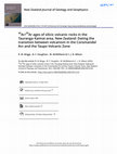
Volcanic rocks exposed in the Tauranga area and Kaimai Range represent an important geographical ... more Volcanic rocks exposed in the Tauranga area and Kaimai Range represent an important geographical and chronological transition from the Miocene-Pliocene Coromandel Volcanic Zone (CVZ) to the Pleistocene-Recent Taupo Volcanic Zone (TVZ) (Fig. ). The Tauranga-Kaimai area contains at least 21 dacite-rhyolite domes or dome complexes together with 3 defined ignimbrite formations that are inferred to predate the onset of TVZ volcanism. The topographically higher domes and flows of the Tauranga-Kaimai area are in part covered and encircled by the younger, voluminous, and partially welded ignimbrites derived from the Rotorua Volcanic Centre in the TVZ to the south. Previously available radiometric ages (see discussion below) from rocks of the Tauranga-Kaimai area were inadequate to constrain the transition between the two volcanic zones. Here, we present new 40 Ar/ 39 Ar age data on the volcanic rocks of the Tauranga-Kaimai area, in an attempt to date the transition between volcanism in the Coromandel Arc and that in the TVZ. We use these new data to constrain the timing of major displacement on the Hauraki Fault, which defines the eastern margin of the Hauraki Rift, and discuss some preliminary geochemical, mineralogical, and spatial relations of rhyolitic and dacitic volcanics within what are defined in and here as the Tauranga and Kaimai Volcanic Centres.
Geophysical Journal International, 1996
The central Taupo Volcanic Zone (TVZ) of New Zealand is a region of intense Quaternary silicic vo... more The central Taupo Volcanic Zone (TVZ) of New Zealand is a region of intense Quaternary silicic volcanism, active since 1.6 Ma. We report palaeomagnetic measurements from 59 distinct volcanic units sampled at 98 sites in the TVZ. These are mainly rhyolitic ignimbrites and lava domes, with a few basaltic, andesitic, and dacitic lavas. Most have new K/Ar or 4oAr/39Ar ages. The remanent magnetizations are generally stable to both thermal and alternating-field demagnetization, and well-determined mean palaeodirections were obtained for all sites. Our findings suggest that the Taupo, Whakamaru, Maroa, Reporoa, Rotorua, and Okataina volcanic centres were magnetized during the Brunhes normal chron. Kapenga is an older volcanic centre, where activity commenced around 0.89 Ma and extended into the Brunhes. Mangakino volcanic centre is significantly older and was active from 1.6 to 0.95 Ma. Transitional or intermediate palaeodirections were obtained from Ahuroa ignimbrite (1.18 kO.02 Ma) and Mamaku ignimbrite (0.22k0.01 Ma). The former almost certainly corresponds to the Cobb Mountain Event. The latter is significantly older than the Blake Event, and probably corresponds to the recently reported Pringle Falls/Summer Lake magnetic episode. Multiple sites from the Whakamaru ignimbrite have indistinguishable 4oAr/39Ar ages (0.33 f 0.01 Ma) and glass composition, but divergent palaeomagnetic directions. This contrast suggests that either ( 1) the different sites were formed during a phase of extremely violent activity, lasting up to a few hundred years, during which geomagnetic secular variation was recorded; or (2) that they were formed in a single eruption, and rotation during subsequent extensional tectonism has caused divergence of the palaeodirections. 40Ar/39Ar ages of 0.77 0.03 Ma for the reversely magnetized Rahopeka ignimbrite and 0.71 k 0.06 Ma for the overlying normally magnetized Waiotapu ignimbrite bracket and constrain the age of the Matuyama-Brunhes transition.

Journal of geomagnetism and geoelectricity, 1997
Andesite lava sequences of the Quaternary Ruapehu Volcano, New Zealand were studied to obtain pal... more Andesite lava sequences of the Quaternary Ruapehu Volcano, New Zealand were studied to obtain paleosecular variations, both direction and intensity. K-Ar dating was performed on 7 lavas of the younger Whakapapa Formation and 22 lavas of the older Te Herenga Formation. Initial experiments by the isotope dilution method using an 38Ar spike were unsuccessful on the younger lavas, while an amplitude method in which the abundance of Ar is estimated from a peak height of mass spectrum gave consistent results of 32 f 12 ka after the correction of the Ar isotopic ratios for mass dependent fractionation. The latter method also gave a more accurate result of 229 ± 35 ka for the older group. No significant relationship was observed in age versus stratigraphy for the 250 m thick older lava section. This suggests a short time span, less than the errors of dating, for the lava accumulation. Primary paleodirections were easily obtained, after cleaning by both AF and thermal demagnetization, from all lavas except two in which a possible effect of lightning was suspected. Paleointensity experiments, using mainly the Shaw method, were made on 15 lavas which showed good stability to thermal demagnetization. In the analysis of the Shaw results, the correction method of Kono (1978) was applied, since most samples showed changes in ARM capacity after heating. The double heating technique of was also applied to some lavas, and was useful to discriminate erroneous data when inconsistent results were obtained. Serial correlation was not detected in the paleodirections of any series of the lavas. In spite of the random appearance of the data, the dipole direction was not obtained from the older section which included 20 data.
Bulletin of Volcanology, 1995
The 1800a Taupo eruption was one of the most complex silicic eruptions worldwide within the past ... more The 1800a Taupo eruption was one of the most complex silicic eruptions worldwide within the past 5000 years. New work on phases 3 and 4, the Hatepe and Rotongaio ashes, has identified a mappable internal stratigraphy for each, enabling detailed isopach and isopleth measurements for subunits within the deposits. The new data indicate that the vent configuration for the Taupo eruption was more complex than previously thought and involved at least three sources on a NE-SW fissure centred on Horomatangi Reefs. Phases 1-3 of the eruption were from a southwestern vent(s), phase 4 from a northeastern source, and phases 5 and 6 probably from the Horomatangi Reefs area. A separate source for the Rotongaio ash (phase 4) helps explain the contrast between the pumice-rich phases of the eruption and the dense juvenile clasts of the Rotongaio ash. The Rotongaio magma resided in a separate, initially blind conduit and was degassing prior to and during earlier phases of the Taupo eruption. This new work on the Hatepe and Rotongaio ashes underscores the importance of a detailed stratigraphic framework in deciphering extremely fine-grained fall units of largescale sustained eruptions.

Bulletin of Volcanology
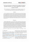
Data collected during well-observed eruptions can lead to dramatic increases in our understanding... more Data collected during well-observed eruptions can lead to dramatic increases in our understanding of volcanic processes. However, the necessary prioritization of public safety and hazard mitigation during a crisis means that scientific opportunities may be sacrificed. Thus, maximizing the scientific gains from eruptions requires improved planning and coordinating science activities among governmental organizations and academia before and during volcanic eruptions. One tool to facilitate this coordination is a Scientific Advisory Committee (SAC). In the USA, the Community Network for Volcanic Eruption Response (CONVERSE) has been developing and testing this concept during workshops and scenario-based activities. The December 2020 eruption of Kīlauea volcano, Hawaii, provided an opportunity to test and refine this model in real-time and in a real-world setting. We present here the working model of a SAC developed during this eruption. Successes of the Kīlauea SAC (K-SAC) included broadening the pool of scientists involved in eruption response and developing and codifying procedures that may form the basis of operation for future SACs. Challenges encountered by the K-SAC included a process of review and facilitation of research proposals that was too slow to include outside participation in the early parts of the eruption and a decision process that fell on a small number of individuals at the responding volcano observatory. Possible ways to address these challenges include (1) supporting community-building activities between eruptions that make connections among scientists within and outside formal observatories, (2) identifying key science questions and pre-planning science activities, which would facilitate more rapid implementation across a broader scientific group, and (3) continued dialog among observatory scientists, emergency responders, and non-observatory scientists about the role of SACs. The SAC model holds promise to become an integral part of future efforts, leading in the short and longer term to more effective hazard response and greater scientific discovery and understanding.
Bulletin of the New Zealand Society for Earthquake Engineering, 2002
In 1998, changes in a number of indicators (earthquakes and uplift) at two of New Zealand's a... more In 1998, changes in a number of indicators (earthquakes and uplift) at two of New Zealand's active volcanic caldera systems (Okataina and Taupo) resulted in increased public, local and central government awareness and some concern about the potential significance of volcanic unrest at a caldera volcano. This paper summarises the episodes of unrest recorded at Taupo caldera since 1895. There have been four significant events (1895, 1922, 1963-64 and 1983) that have included earthquake activity and ground deformation. Caldera unrest is one of the most difficult situations the volcanological and emergency management communities will have to deal with. There is potential for adverse social and economic impacts to escalate unnecessarily, unless the event is managed appropriately. Adverse response to caldera unrest may take the form of the release of inappropriate advice, media speculation, unwarranted emergency declarations and premature cessation of economic activity and community s...
Volcanica, 2019
The 10th century Eldgjá fissure eruption is the largest in Iceland in historical time. It erupted... more The 10th century Eldgjá fissure eruption is the largest in Iceland in historical time. It erupted 21.0 km3 of magma, with 1.3 km3 as tephra in at least 16 explosive episodes from subaerial and subglacial vents, producing magmatic and phreatomagmatic deposits respectively. Grain-size distributions for these end-members show distinct differences at comparable distances from source: the former are coarser and unimodal; the latter are finer and bimodal. These distributions appear to record different primary fragmentation histories. In contrast, the vesicle-size distributions of pyroclasts from each type of deposit show the pyroclasts underwent similar vesicle nucleation and growth prior to fragmentation. This indicates that the role of glacial water was comparatively late-stage, re-fragmenting an already disrupting magma by quench granulation. The presence of microlite-rich domains within clasts reveals a history of complex conduit evolution, during the transition from a continuous dyke...

Science advances, 2018
The 2012 submarine eruption of Havre volcano in the Kermadec arc, New Zealand, is the largest dee... more The 2012 submarine eruption of Havre volcano in the Kermadec arc, New Zealand, is the largest deep-ocean eruption in history and one of very few recorded submarine eruptions involving rhyolite magma. It was recognized from a gigantic 400-km2 pumice raft seen in satellite imagery, but the complexity of this event was concealed beneath the sea surface. Mapping, observations, and sampling by submersibles have provided an exceptionally high fidelity record of the seafloor products, which included lava sourced from 14 vents at water depths of 900 to 1220 m, and fragmental deposits including giant pumice clasts up to 9 m in diameter. Most (>75%) of the total erupted volume was partitioned into the pumice raft and transported far from the volcano. The geological record on submarine volcanic edifices in volcanic arcs does not faithfully archive eruption size or magma production.

New Zealand Journal of Geology and Geophysics, 1992
The age of the Rotoehu Ash is estimated as 64 ± 4 ka from whole-rock K-Ar age determinations on o... more The age of the Rotoehu Ash is estimated as 64 ± 4 ka from whole-rock K-Ar age determinations on older and younger lava flows on Mayor Island volcano. This age is compatible with an existing U/Th disequilibrium age of 71 ± 6 ka and both are significantly older than the currently accepted value of 50 ka.