Recent intense hurricane response to global climate change (original) (raw)
3.1 Data
The tropical cyclone analysis is based on the global IBTrACS data set (Knapp et al. [2010](/article/10.1007/s00382-013-1713-0#ref-CR23 "Knapp KR, Kruk MC, Levinson DH, Diamond HJ, Neumann CJ (2010) The international best track archive for climate stewardship (IBTrACS). Bull Am Meteor Soc 91:363–376. www.ncdc.noaa.gov/oa/ibtracs/
            ")). A homogeneous satellite reanalysis by Kossin et al. ([2007](/article/10.1007/s00382-013-1713-0#ref-CR28 "Kossin JP, Knapp KR, Vimont DJ, Murnane RJ, Harper BA (2007) A globally consistent reanalysis of hurricane variability and trends. Geophys Res Lett 34:L04815. doi:
                10.1029/2006GL028836


            ")) found close agreement of the archived intensities in the North Atlantic and western North Pacific, but there were inconsistencies for more intense storms in the other regions. We utilize the recent update to this analysis (Kossin [2012](/article/10.1007/s00382-013-1713-0#ref-CR27 "Kossin JP (2012) Personal communication")) as an independent check on the IBTrACS results.
Archived intensities are somewhat of a hodge-podge of different approaches and definitions. Even at the most basic level, the definition of wind speed varies considerably around the globe, with 1, 10, 3 and even 2-min averaging periods in use (Harper et al. 2008). Some homogenization is provided by the universal use of the Dvorak satellite interpretation technique (Velden et al. 2006; Knaff et al. [2010](/article/10.1007/s00382-013-1713-0#ref-CR22 "Knaff JA, Brown DP, Courtney J, Gallina GM, Beven JL II (2010) An evaluation of Dvorak technique-based tropical cyclone intensity estimates. Weather Forecast 25:1362–1379. doi: 10.1175/2010WAF2222375.1
")) but there remain issues with the approaches used to convert from the satellite pattern code to a surface wind speed.These issues are particularly evident in the western North Pacific, where there are four different archival centers: the Joint Typhoon Warning Center (JTWC), the Hong Kong Observatory (HKO), the Shanghai Typhoon Institute (STI) and the WMO Regional Specialized Meteorological Center, Tokyo (RSMC). Maximum winds for each of these archives are based on: 1-min mean at JTWC, 10-min mean at HKO and RSMC, and 2-min mean at STI. Furthermore, aircraft reconnaissance provided a substantial basis for intensity estimates until 1988 after which the Dvorak technique became the major approach. Varying approaches to converting the Dvorak analysis to intensity has resulted in a divergence of intensity trends amongst the centers, with the JTWC data containing an increasing intensity trend and the HKO and RSMC a decreasing one (Wu et al. 2006; Song et al. [2010](/article/10.1007/s00382-013-1713-0#ref-CR36 "Song J-J, Wang Y, Wu L (2010) Trend discrepancies among three best track data sets of western North Pacific tropical cyclones. J Geophys Res 115:D12128. doi: 10.1029/2009JD013058
")).Wu and Zhao ([2012](/article/10.1007/s00382-013-1713-0#ref-CR42 "Wu L, Zhao H (2012) Dynamically derived tropical cyclone intensity changes over the Western North Pacific. J Clim 25:89–98. doi: 10.1175/2011JCLI4139.1
")) examined these discrepancies using the Emanuel ([2008](/article/10.1007/s00382-013-1713-0#ref-CR10 "Emanuel KA (2008) The Hurricane—climate connection. Bull Am Meteor Soc 89:ES10–ES20")) statistical-dynamical downscaling technique. They found an increasing intensity trend that also is supported by observed relationships with SST and vertical shear, and is in broad agreement with the observed increasing tendency for equatorial developments and longer time spent in favorable conditions. This lends support to the JTWC archive, though the Wu and Zhao trends were less than those for JTWC.Based on this analysis, we adopt the following procedure for assessing hurricane trends:
- Except for the western North Pacific, we use the IBTrACS data without change. IBTrACS has been converted to a uniform 10-min mean wind definition (Knapp et al. 2010). For the western North Pacific, we use the JTWC data set without correction aside from conversion to 10-min mean.
- To help minimize uncertainties, including the intensity definition variations, we bin all hurricanes into the Saffir–Simpson category ranges (Simpson and Rielh 1981). This is for consistency with other studies. The Saffir–Simpson ranges are not constant, varying slightly from one category to another, but a check using fixed-width bins found no notable differences. Even though the Cat 4–5 interval has no explicit upper bound, it is effectively bounded by available energy as defined by the potential intensity (Emanuel 1987) and is approximately the same width as Cat 1–2.
- All variance numbers use the 5-years smoothed annual time series to remove ENSO type variability. These include contributions from both trend and multi-year variance. The p values are calculated from the raw annual data to ensure no serial correlation.
We also conduct several additional data quality checks:
- We recalculate our main conclusions from the IBTrACS data using:
- The recently upgraded satellite data set and automated analysis from Kossin (2012), and
- A land-proximity dataset derived from the global IBTrACS data. These are interpolated to add nine points between each 6-h position in the archive; land proximity is then defined by whenever the tropical cyclone moves to within 0.5° lat/long of land, with the land mask having 1 min resolution (~2 km);
- An independent global landfall data set used in a recent study (Weinkle et al. 2012).
- We further compare the observed changes to recent climate simulations with the dynamical downscaling results of Bender et al. (2010), Done et al. (2012), and Wu and Zhao (2012).
3.2 Tropical cyclone frequency
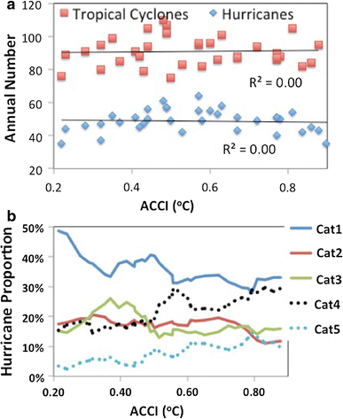
The global annual frequency of all tropical cyclones (Fig. 3a) has remained essentially constant with ACCI, aside from a general variability with amplitude around 10 % from the mean for the whole period. This remarkable degree of global consistency has been noted in several previous studies [see Frank and Young ([2007](/article/10.1007/s00382-013-1713-0#ref-CR11 "Frank WM, Young GS (2007) The interannual variability of tropical cyclones. Mon Weather Rev 135:3587–3598. doi: 10.1175/MWR3435.1
")) for a summary\]. Note that the lack of trend does not carry over to individual ocean basins, some of which have experienced trends since 1975 with the standouts being a substantial decrease in the western North Pacific and an increase in the North Atlantic (Webster et al. [2005](/article/10.1007/s00382-013-1713-0#ref-CR40 "Webster PJ, Holland GJ, Curry JA, Chang H-R (2005) Changes in tropical cyclone number, duration and intensity in a warming environment. Science 309:1844–1846")). We imply no causes for these in this study; they could be due to either or both of natural variability and climate change.Fig. 3
Anthropogenic influence on: a annual frequency of global tropical cyclones and hurricanes; b hurricane proportions in each of the Saffir–Simpson hurricane categories
3.3 Hurricane proportion
Hurricanes as a family also have experienced no global trend with anthropogenic warming (Fig. 3a), but have a marked low-frequency variation with a maximum around the middle of the analysis period. By contrast, previous studies have reported a marked upward trend in intense hurricanes (Webster et al. 2005; Emanuel 2005, 2007; Elsner et al. 2008), one that is closely related to increasing SST (Hoyos et al. 2010). This trend in intense hurricanes is the focus of the remainder of our analysis.
We bin all hurricanes into the five Saffir–Simpson categories and take annual proportions of each relative to the total number of hurricanes. These are smoothed with a 5-year running mean to remove short-term variability. The resulting relationship with ACCI (Fig. 3b) has a sustained decrease of Cat 1 hurricanes for increasing ACCI; Cat 2 hurricanes have little relationship for lower ACCI values, but decrease towards higher ACCI; little real change is observed in Cat 3 aside from an initial slight increase and then similar decline; and Cat 4 and 5 hurricanes both increase markedly with ACCI. Based on these results we further bin the hurricane proportions into Cat 1–2 and Cat 4–5 for analysis.
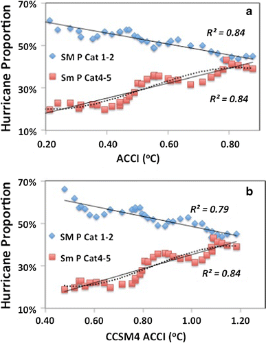
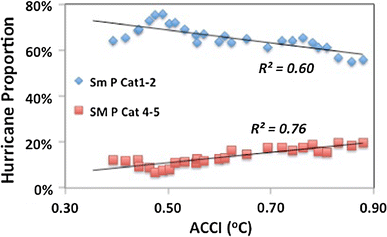
A sustained upward trend is found between the global proportion of Cat 4–5 hurricanes and ACCI (Fig. 4), balanced by a similar decrease in Cat 1–2 hurricanes. The results are independent of the choice of models to calculate the ACCI as can be seen by comparing Fig. 4a and b. In both cases the ACCI explains 80–85 % of the variance in the smoothed annual hurricane proportions with p < 0.01 (using unsmoothed data). This finding is consistent with the SST-related increases in Cat 4–5 and decreases in Cat 1–2 found by Kishtawal et al. ([2012](/article/10.1007/s00382-013-1713-0#ref-CR20 "Kishtawal CM, Jaiswal N, Singh R, Niyogi D (2012) Tropical cyclone intensification trends during satellite era (1986–2010). Geophys Res Lett 39:L10810. doi: 10.1029/2012GL051700
            ")), the relationship of intense hurricanes with SST found by Hoyos et al. ([2010](/article/10.1007/s00382-013-1713-0#ref-CR16 "Hoyos CD, Agudelo PA, Webster PJ, Curry JA (2010) Deconvolution of the factors contributing to the increase in global hurricane intensity. Science 312:94–97")), and the Atlantic landfall hurricane changes noted by Grinsted et al. ([2012](/article/10.1007/s00382-013-1713-0#ref-CR12 "Grinsted A, Moore JC, Jevreva S (2012) Homogeneous record of Atlantic hurricane surge threat since 1923. Proc Nat Acad Sci. Published online before print October 15, 2012. doi:
                10.1073/pnas.1209542109


            ")).
Fig. 4
Relationship of anthropogenic change defined from: a CMIP3 and, b CCSM4 with annual proportions of Cat 1–2 and Cat 4–5 hurricanes. Note the different scales for the ACCI. A 5-year running mean smoother has been used (indicated by the SM in the legend), thin solid (dashed) lines indicate linear (quadratic) trends, and all variances have p < 0.01 (using unsmoothed data)
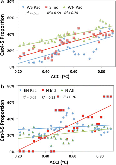
The global relationship also is consistently reproduced in each ocean basin, although the eastern North Pacific and North Atlantic increases have p > 0.05 (Fig. 5). Note that the global ACCI has been used for these regional comparisons to ensure comparison with the global climate change without contamination from regional variations. This relationship between ACCI and regional Cat 4–5 proportions is consistent with the SST-related findings for the globe by Hoyos et al. (2010), for the North Pacific by Emanuel (2005), and for the North Atlantic by Elsner ([2006](/article/10.1007/s00382-013-1713-0#ref-CR5 "Elsner JB (2006) Evidence in support of the climate change-Atlantic hurricane hypothesis. Geophys Res Lett 33:L16705. doi: 10.1029/2006GL026869
            ")) and Grinsted et al. ([2012](/article/10.1007/s00382-013-1713-0#ref-CR12 "Grinsted A, Moore JC, Jevreva S (2012) Homogeneous record of Atlantic hurricane surge threat since 1923. Proc Nat Acad Sci. Published online before print October 15, 2012. doi:
                10.1073/pnas.1209542109


            ")). It is notable that the regional Cat 4–5 relationship is independent of the trend in all tropical cyclones; for example both the western North Pacific and North Atlantic have increasing trends in Cat 4–5 proportions even though the total number of hurricanes has gone down in the Pacific and up in the Atlantic.
Fig. 5
Relationship between global ACCI and annual Cat 4–5 hurricane proportions by ocean basin. A 5-year running mean smoothing has been used. The variances in a have p < 0.01 and the North Indian trend has p < 0.05 (using unsmoothed data)
By using proportions, we are thus assessing overall changes in the probability distribution function (PDF) without contamination by changes in total numbers that can easily mask the true intense hurricane signal. This explains the apparent difference with the findings of a negative Cat 4–5 trend in the western North Pacific and some other ocean basins by Klotzbach ([2006](/article/10.1007/s00382-013-1713-0#ref-CR21 "Klotzbach PJ (2006) Trends in global tropical cyclone activity over the past twenty years (1986–2005). Geophys Res Lett 33:L10805. doi: 10.1029/2006GL025881
")).The North Atlantic is an interesting situation. The proportions have changed consistently with the globe as a whole but the slope is smaller. Since 1995 there has been a marked increase in the annual frequency of North Atlantic tropical cyclones, including intense hurricanes and these are closely aligned with increasing North Atlantic SST [see Bruyère et al. (2012) for a detailed discussion], the global balance (Fig. 3a) has been maintained by a corresponding decrease for annual tropical cyclones in the western North Pacific. This leads to the intriguing possibility that for individual regions the degree of proportional change is inversely related to concomitant change in the total numbers. Further investigation of this potential relationship is ongoing.
3.4 Discussion
The strong and consistent relationship between increasing proportions of intense hurricanes and the ACCI is striking and points to a substantial observed anthropogenic increase in intense hurricanes. But could there be an alternative explanation?
3.4.1 Analysis issues
One possible trend error arises from the universal use of the Dvorak technique. There may have been a consistent change in analysis practice and/or satellite data that led to increasing analysis of intense systems over the time period (Knaff et al. [2010](/article/10.1007/s00382-013-1713-0#ref-CR22 "Knaff JA, Brown DP, Courtney J, Gallina GM, Beven JL II (2010) An evaluation of Dvorak technique-based tropical cyclone intensity estimates. Weather Forecast 25:1362–1379. doi: 10.1175/2010WAF2222375.1
            ")). We check this potential impact by using the objective satellite-based reanalysis undertaken by Kossin et al. ([2007](/article/10.1007/s00382-013-1713-0#ref-CR28 "Kossin JP, Knapp KR, Vimont DJ, Murnane RJ, Harper BA (2007) A globally consistent reanalysis of hurricane variability and trends. Geophys Res Lett 34:L04815. doi:
                10.1029/2006GL028836


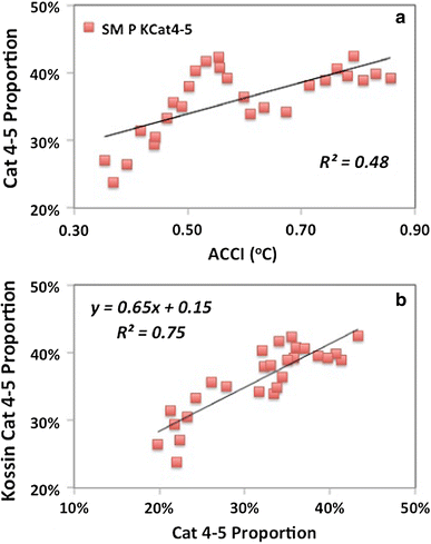
            ")). As shown in Fig. [6](/article/10.1007/s00382-013-1713-0#Fig6) and Table [1](/article/10.1007/s00382-013-1713-0#Tab1), the homogenized data of Kossin ([2012](/article/10.1007/s00382-013-1713-0#ref-CR27 "Kossin JP (2012) Personal communication")) clearly contain a similar signal, though at a reduced trend compared to IBTrACS. The weaker trend may be attributed to two factors: the automated Dvorak analysis used by Kossin may underestimate the most intense storms, or there may be an artificial analysis trend in the archived data.
Fig. 6
Relationship between: a anthropogenic change and annual Cat 4–5 hurricane proportions from Kossin (2012) reanalysis; b comparison of IBTrACS (abscissa) and Kossin Cat 4–5 proportions. A 5-year running mean smoothing has been used and all variances have p < 0.01 (using unsmoothed data)
Table 1 Comparison of the observed changes in the proportion of Cat 4–5 hurricanes per °C of global warming compared with those derived from the indicated sources
On a regional basis, Wu and Zhao ([2012](/article/10.1007/s00382-013-1713-0#ref-CR42 "Wu L, Zhao H (2012) Dynamically derived tropical cyclone intensity changes over the Western North Pacific. J Clim 25:89–98. doi: 10.1175/2011JCLI4139.1
            ")) applied the Emanuel ([2008](/article/10.1007/s00382-013-1713-0#ref-CR10 "Emanuel KA (2008) The Hurricane—climate connection. Bull Am Meteor Soc 89:ES10–ES20")) dynamical downscaling approach to reanalysis data for the western North Pacific and found a significant increase in the frequency of Cat 4–5 hurricanes (Table [1](/article/10.1007/s00382-013-1713-0#Tab1)) that is similar to that in Fig. [4](/article/10.1007/s00382-013-1713-0#Fig4)b after taking proportions, but at around half the rate. Grinsted et al. ([2012](/article/10.1007/s00382-013-1713-0#ref-CR12 "Grinsted A, Moore JC, Jevreva S (2012) Homogeneous record of Atlantic hurricane surge threat since 1923. Proc Nat Acad Sci. Published online before print October 15, 2012. doi:
                10.1073/pnas.1209542109


            ")) used a homogeneous index of storm surge on the US coast to examine potential changes in landfalling hurricanes for both current and future climate. They found a significant increase at a factor of 2–7 in ‘Katrina-like’ hurricanes for each 1 °C increase in global SST associated with global warming.
Hurricanes in proximity to land have better observations than those well out to sea and provide another check to the quality of the overall results. The global landfall results (as defined in Sect. 3.1) contain the same overall trends (Fig. 7) as were found for the entire data set in Fig. 4a. Cat 4–5 proportions are lower than those for the global hurricane data, an expected result since high intensities are only maintained for a relatively short period of the overall cyclone lifetime and could easily be missed by the similarly short period spent within landfall range. The slope of the Cat 4–5 trend for this land-proximity subset is ~27 % per °C, essentially the same as the ~29 % per °C from the Kossin (2012) homogenized satellite data in Fig. 6a.
Fig. 7
Relationship of anthropogenic change to annual proportions of Cat 1–2 and Cat 4–5 hurricanes in proximity to land. A 5-year running mean smoothing has been used, thin solid lines indicate linear trends, and all variances have p < 0.01 (using unsmoothed data)
General agreement with Fig. 7 is found for landfall in each ocean basin except the North Indian Ocean and the western North Pacific. The landfall rarity of intense North Indian Ocean hurricanes means the data are too noisy for analysis. For the western North Pacific the trend is very weak and slightly negative, which we attribute to a general eastward and equatorward movement of the main genesis location in recent decades (Wu and Zhao [2012](/article/10.1007/s00382-013-1713-0#ref-CR42 "Wu L, Zhao H (2012) Dynamically derived tropical cyclone intensity changes over the Western North Pacific. J Clim 25:89–98. doi: 10.1175/2011JCLI4139.1
")). This promotes the development of a higher proportion of intense hurricanes, but also means that fewer of them will make landfall.Weinkle et al. ([2012](/article/10.1007/s00382-013-1713-0#ref-CR41 "Weinkle J, Maue R, Pielke R Jr (2012) Historical global tropical cyclone landfalls. J Clim. doi: 10.1175/JCLI-D-11-00719.1
(early release)")) examined the global number of hurricanes that actually make landfall in each of the Saffir–Simpson categories. The proportion of Cat 4–5 at landfall to all landfall hurricanes in their data set has increased with ACCI at a rate of \~21 % per °C (_p_ < 0.01) since 1975.This study leads us to the following observational conclusions. Over the past few decades there has been an observed ~40 % per °C trend relative to the ACCI in the proportion of IBTrACS Cat 4–5 hurricanes (p < 0.01) and a compensating decrease in Cat 1–2 proportions. Comparison with the Kossin (2012) homogenized satellite data and with global sets of tropical cyclones in proximity to land indicates that changing analysis and observing practices may have contributed 10–15 % of the IBTrACS trend. This leaves a real trend in the proportion of Cat 4–5 hurricanes of 25–30 % per °C that is directly attributed to anthropogenic warming as defined by the ACCI. This is in agreement with that derived from other studies (Table 1).
If annual mean tropical SST is used instead of the ACCI, the trend in proportion of Cat 4–5 hurricanes after adjusting for analysis errors is ~40 % per °C SST warming (see Fig. 2b and associated discussion). These represent an increase of more than double in the proportion of intense hurricanes, which is in agreement with, but less than, the 2–7 times increase found in Katrina-like storms by Grinsted et al. ([2012](/article/10.1007/s00382-013-1713-0#ref-CR12 "Grinsted A, Moore JC, Jevreva S (2012) Homogeneous record of Atlantic hurricane surge threat since 1923. Proc Nat Acad Sci. Published online before print October 15, 2012. doi: 10.1073/pnas.1209542109
")) for the North Atlantic.3.4.2 Comparison with model simulations
The observed trend in Cat 4–5 hurricanes is consistent with independent modeling studies. Oouchi et al. ([2006](/article/10.1007/s00382-013-1713-0#ref-CR34 "Oouchi K, Yosimura J, Mizuta R, Kusonoki S, Noda A (2006) Tropical cyclone climatology in a global-warming climate as simulated in a 20 km mesh global atmospheric model: frequency and wind intensity analyses. J Meteorol Soc Jpn 84:259–276. doi: 10.2151/jmsj.84.259
")) found a general increase in the most intense hurricanes and a decrease in weaker ones for a time-slice simulation forced by current and future surface temperatures and greenhouse gases; similar findings were made by Bengtsson et al. ([2007](/article/10.1007/s00382-013-1713-0#ref-CR2 "Bengtsson L, Hodges KI, Esch M, Keenlyside N, Kornblueh L, Luo J-J, Yamagata T (2007) How may tropical cyclones change in a warmer climate? Tellus 59A:539–561")). Bender et al. ([2010](/article/10.1007/s00382-013-1713-0#ref-CR1 "Bender MA, Knutson TR, Tuleya RE, Sirutis JJ, Vecchi GA, Garner ST, Held IM (2010) Modeled impact of anthropogenic warming on the frequency of intense Atlantic hurricanes. Science 327:454–458")) examined the potential climate changes in North Atlantic hurricanes using two versions of the GFDL hurricane model as a downscaling tool applied to tropical cyclones generated in the GFDL climate model. The technique for the climate simulation was to use current climate boundary conditions (horizontal and surface) plus a constant change in thermodynamic parameters (Knutson et al. [2007](/article/10.1007/s00382-013-1713-0#ref-CR24 "Knutson TR, Sirutis JJ, Garner ST, Held IM, Tuleya RE (2007) Simulation of the recent multidecadal increase of Atlantic hurricane activity using an 18-km-grid regional model. Bull Am Meteorol Soc 88:1549–1565")). Bender et al. ([2010](/article/10.1007/s00382-013-1713-0#ref-CR1 "Bender MA, Knutson TR, Tuleya RE, Sirutis JJ, Vecchi GA, Garner ST, Held IM (2010) Modeled impact of anthropogenic warming on the frequency of intense Atlantic hurricanes. Science 327:454–458")) found that for each °C of global warming the proportion of Cat 4–5 hurricanes increased by \~11 % and the proportion of Cat 1–2 hurricanes decreased by \~7 %.Done et al. ([2012](/article/10.1007/s00382-013-1713-0#ref-CR4 "Done JM, Holland GJ, Bruyère CL, Leung LR, Suzuki-Parker A (2012) Modeling high-impact weather and climate: lessons from a tropical cyclone perspective. NCAR/TN-490 + STR, p 28. [Available online at http://nldr.library.ucar.edu/repository/collections/TECH-NOTE-000-000-000-854
              ]")) applied Weibull and Generalized Pareto distributions to assess the expected changes in future North Atlantic hurricane extremes based on changes to the mean and variance of the truncated distribution predicted by the NCAR Nested Regional Climate Model (Done et al. [2012](/article/10.1007/s00382-013-1713-0#ref-CR4 "Done JM, Holland GJ, Bruyère CL, Leung LR, Suzuki-Parker A (2012) Modeling high-impact weather and climate: lessons from a tropical cyclone perspective. NCAR/TN-490 + STR, p 28. [Available online at
                http://nldr.library.ucar.edu/repository/collections/TECH-NOTE-000-000-000-854

              ]")). Both approaches showed that relatively modest increases in the mean (3 %) and standard deviation of (7 %) produced an increase in the proportion of Cat 4–5 hurricanes of \~15 % per °C of global warming.
3.4.3 Impact of internal variability
There is a possibility that some of the observed trend arises from internal tropical cyclone variability that has aliased into the 35-year period used here. However, we consider that a substantial contamination from internal variability is highly unlikely. By using global mean temperatures in the development of the ACCI, we have explicitly excluded all but external forcing factors from this aspect of the analysis. There could be an influence of 11-year sun cycles or impulsive events such as volcanoes, but we suggest that the period chosen is too long for these to have a cumulative effect on the trend.
For global hurricane proportions, we are aware of no association with internal variability such as the Pacific Decadal Oscillation or similar. Figure 4 contains potentially interesting short-period variability but as shown by the quadratic fit to the Cat 4–5 proportions the trend appears to be very close to linear as would be expected from a response to the global warming trend. By using global data we also have removed any potential issues from recent discussion over whether relative or in situ SSTs are the driving influence in specific ocean basins (Vecchi and Soden 2007). The consistent regional Cat 4–5 relationship with global ACCI argues for the regional changes observed here being unaffected by relative processes and thus due largely to global changes.
Further evidence for the lack of a contribution from internal variability is provided by the modeling results for the North Atlantic in Table 2. Because of the experimental configuration for these modeling studies, the simulated changes contained no contribution from internal variability.
Table 2 Comparison North Atlantic changes for Cat 4–5 hurricanes, showing that the differing study results arise from the use of different base periods, and that a final, saturation proportion may be reached at around 30–35 % of Cat 4–5 hurricanes
3.4.4 Comparison with extreme value analysis
The generally agreed expected increase in overall tropical cyclone intensity with global warming is around 5 % per °C, or an increase of around 2–3 m s−1 (Emanuel [1987](/article/10.1007/s00382-013-1713-0#ref-CR7 "Emanuel KA (1987) The dependence of hurricane intensity on climate. Nature 326:483–485. doi: 10.1038/326483a0
            "); Henderson-Sellers et al. [1998](/article/10.1007/s00382-013-1713-0#ref-CR14 "Henderson-Sellers A, Zhang H, Berz G, Emanuel K, Gray W, Landsea C, Holland G, Lighthill J, Shieh S-L, Webster P, McGuffie K (1998) Tropical cyclones and global climate change: a post-IPCC assessment. Bull Am Meteor Soc 79:19–38"); Knutson et al. [2010](/article/10.1007/s00382-013-1713-0#ref-CR26 "Knutson TR, McBride JL, Chan J, Emanuel K, Holland GJ, Landsea CW, Held CI, Kossin JP, Srivastava AK, Sugi M (2010) Tropical cyclones and climate change. Nat Geosci 3:157–163")). It is often assumed that this means negligible change in hurricane extremes, but this can easily be shown to be incorrect by fitting an extreme distribution to the tropical cyclone PDF and examining the changes in extremes resulting from small bulk changes. For example, by fitting a Weibull distribution to the current tropical cyclone PDF \[see Done et al. ([2012](/article/10.1007/s00382-013-1713-0#ref-CR4 "Done JM, Holland GJ, Bruyère CL, Leung LR, Suzuki-Parker A (2012) Modeling high-impact weather and climate: lessons from a tropical cyclone perspective. NCAR/TN-490 + STR, p 28. [Available online at
                http://nldr.library.ucar.edu/repository/collections/TECH-NOTE-000-000-000-854

              ]")) for discussion on the method\] it can readily be shown that a change of 2–3 m s−1 in both the mean and standard deviation—similar to the resolution of the IBTrACS—produces a \~20 % increase in the proportion (equivalent to doubling) of Cat 4–5 hurricanes. Such a sensitivity of the extremes to relatively small changes in the mean and standard deviation is well known and has been emphasized by the IPCC ([2012](/article/10.1007/s00382-013-1713-0#ref-CR19 "IPCC (2012) Managing the risks of extreme events and disasters to advance climate change adaptation.
                http://ipcc-wg2.gov/SREX/

              , p 582"), their Fig. SPM3).
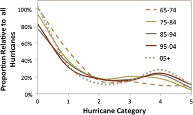
However, there seems to be much more happening than the straightforward ‘wagging of the tail’ implied by extreme value analysis. Rather, the characteristics of the global intensity distribution have changed consistently over the past 30 years (Fig. 8); an initially purely exponential tail has developed bimodal characteristics with a secondary peak at Cat 4 growing consistently from 1965 to the present.
Fig. 8
Evolving proportions of global tropical cyclone proportions (relative to all hurricanes) binned into tropical storms (indicated by 0) and the five Saffir–Simpson categories over the indicted decades
We hypothesize that this bimodal development arises from the bounded nature of the hurricane intensity distribution. Since the maximum wind intensity is only expected to increase by around 5 % or <5 m s−1 per °C of global warming (e.g. Emanuel [1987](/article/10.1007/s00382-013-1713-0#ref-CR7 "Emanuel KA (1987) The dependence of hurricane intensity on climate. Nature 326:483–485. doi: 10.1038/326483a0
            "); Henderson-Sellers et al. [1998](/article/10.1007/s00382-013-1713-0#ref-CR14 "Henderson-Sellers A, Zhang H, Berz G, Emanuel K, Gray W, Landsea C, Holland G, Lighthill J, Shieh S-L, Webster P, McGuffie K (1998) Tropical cyclones and global climate change: a post-IPCC assessment. Bull Am Meteor Soc 79:19–38")). This leads to a suggested causal chain: global warming provides conditions generally more conducive to intensification through longer periods spent in favorable conditions, with more rapid intensification rates (in agreement with Kishtawal et al. [2012](/article/10.1007/s00382-013-1713-0#ref-CR20 "Kishtawal CM, Jaiswal N, Singh R, Niyogi D (2012) Tropical cyclone intensification trends during satellite era (1986–2010). Geophys Res Lett 39:L10810. doi:
                10.1029/2012GL051700


            ")); the increased intensification rate enables some weaker hurricanes to reach higher intensities; the constraint to the maximum intensity cap then results in a developing bimodal distribution with a secondary peak the Cat 4 level.
3.4.5 Where is the limit?
One curious feature of the observed changes has been their quasi-linear nature (e.g. Fig. 4). Global Cat 4–5 hurricanes have increased in proportion from ~20 % (a third of the proportion of Cat 1–2) in the late 1970’s to be equal to Cat 1–2 at ~40 %. Obviously this linear increase cannot go on indefinitely as the proportion of Cat 4–5 hurricanes cannot exceed one.
Table 2 compares the different values and base periods for the North Atlantic observations with the downscaling by Bender et al. (2010) and Done et al. ([2012](/article/10.1007/s00382-013-1713-0#ref-CR4 "Done JM, Holland GJ, Bruyère CL, Leung LR, Suzuki-Parker A (2012) Modeling high-impact weather and climate: lessons from a tropical cyclone perspective. NCAR/TN-490 + STR, p 28. [Available online at http://nldr.library.ucar.edu/repository/collections/TECH-NOTE-000-000-000-854
              ]")). No adjustment downward was made to the observed Atlantic trend due to analysis issues since North Atlantic intensity archives are reasonably accurate over the period (Kossin et al. [2007](/article/10.1007/s00382-013-1713-0#ref-CR28 "Kossin JP, Knapp KR, Vimont DJ, Murnane RJ, Harper BA (2007) A globally consistent reanalysis of hurricane variability and trends. Geophys Res Lett 34:L04815. doi:
                10.1029/2006GL028836


            ")). When the base period is taken into account, the differing increases in column four converge to a remarkably consistent net increase in Cat 4–5 proportion of \~30–35 %. This suggests that the North Atlantic may saturate at 30–35 % proportion of Cat 4–5 hurricanes after which no further increases with global warming will occur. If true, a further maximum increase in North Atlantic Cat 4–5 proportion of \~10 % from the current level of \~25 % (Fig. [5](/article/10.1007/s00382-013-1713-0#Fig5)b) may be expected.
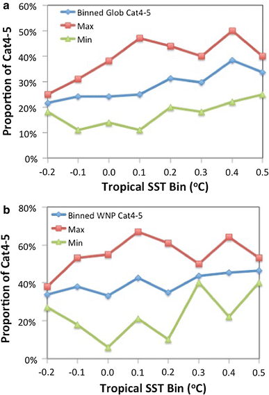
For the globe the saturation limit may be around 40–50 % proportion of Cat 4–5 hurricanes. Figure 9a shows the variation with annual mean tropical SST of the mean, maximum and minimum proportions of Cat 4–5. The data have been extended back to 1950 and binned into 0.1 °C intervals. Note that the tropical SST values contain components of both natural and anthropogenic variability. SST was used because the ACCI is derived from long-term model simulations that cannot reproduce the observed interannual variations. The maxima in Cat 4–5 proportions climbs steeply with increasing SST, then appears to reach a saturation level of 40–50 % while both the means and the minima continue to increase. A similar rapid increase to saturation is apparent for the western North Pacific in Fig. 9b, except that here the saturation level is higher at 60–65 %. The other ocean basins are too noisy for explicit analysis, but they appear to fall between the North Atlantic and western North Pacific.
Fig. 9
Relationship of annual Cat 4–5 proportions to annual variations in tropical SST anomalies relative to the 1975–2010 mean: a global proportions, b western North Pacific proportions. The data are binned into 0.1 °C intervals from which average, maximum, and minimum proportions are derived
These observations suggest that there may be an areal component to the saturation level; small basins (e.g. North Atlantic) saturate at a lower proportions than large basins with their associated larger warm pools (e.g. western North Pacific). This and the ultimate level of potential saturation under continued global warming is subject of a separate study. Questions that arise include: what, if anything, is the relationship with the development of the bimodal intensity distribution (Fig. 8); why is there a variation in the apparent saturation level across different basins; and is there some external climatic factor that determines both this saturation and the remarkably constant annual frequency of tropical cyclones across the globe?
