Southern Wall (Temple Mount)
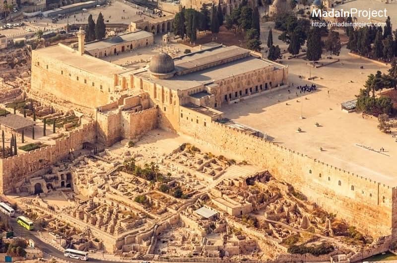
The Southern Wall is a wall at the southern end of the Haram al-Sharif (Temple Mount) and the former southern side of the Second Temple. Herod's Royal Stoa stood atop his extension of the Temple Mount, along the southern flank.
Contents Hide / Show
Remove Ads
Why we're running ads?
The Madain Project is a very unique resource of Abrahamic History & Archaeology; reaching more than half a million readers a month. Until February 2021 all the operational and management costs were being paid by the volunteers working on the project. But, the increase in the userbase and the overall costs of servers and other services and equipment that are needed to remain live forced us to look for other avenues of inflow.
We apologise about it.
We apologise for the inconvenience that ads bring to your reading experience; we're working on a membership model for the Madain Project which will provide you with an absolute ads-free reading.
Please send us an email to madainproject@gmail.com if you'd like to sponsor us.
Cite this article
How to copy: Click the citation text to copy it to the clipboard.
Note: Always review your references and make any necessary corrections before using. Pay attention to names, capitalization, and dates. If you need to mention authors, you can add "the Editors of the Madain Project". The publication date given in the citations reflect the most recent update of the article and not the original publication date; you may wanna check the article's history to see how it has evolved over time.
Use a citation tool.
Want to use our images?
The Madain Project owns the copyright to the Madain Project (en) including (i) the artwork and design of the www.madainproject.com website (Madain Project Website); and (ii) all electronic text and image files, audio and video clips on the Madain Project Website (MP Material) excluding material which is owned by other individuals or organizations as indicated.
Users who would like to make commercial use of Madain Project Material must contact us with a formal written request (i) identifying the MP Material to be used; and (ii) describing the proposed commercial use. Madain Project will review such requests and provide a written response. The Madain Project reserves the right to charge a fee for any approved commercial use of Madain Project Materials.
The Madain Project has an extensive archive of photographs, which is only partially featured on our website. If you cannot find the photographs you're looking for; just send us an email detailing the required site, structure or even illustration. The archives department will definitely assist you in finding the best possible image for your new project.
Overview
The Southern Wall is a wall at the southern end of the Temple Mount and the former southern side of the Second Temple (also called Herod's Temple) in Jerusalem. It was built during King Herod's expansion of the Temple Mount platform southward on to the Ophel. The Southern Wall is 922 feet (281 m) in length, and which the historian Josephus equates as being equal to the length of one furlong.
The retaining southern wall is built of enormous blocks of Jerusalem stone, the face of each ashlar (block) is edged with a margin, the bossage is raised about 3/8" above the surrounding margins. The unmortared blocks are so finely fitted together that a knife blade cannot be inserted between the ashlars.
Notable Structures Along the South Wall
circa 780 CE
al-Aqṣā Mosque
South-west exposure of the Al-Aqsa Mosque along the southern wall of the Temple Mount (Haram al-Sharif), in the Old City of Jerusalem. Considered to be the third holiest site in Islam after Mecca and Medina. The mosque was built on top of the Temple Mount, known as Haram esh-Sharif in Islam. Muslims believe that Muhammad was transported from the Sacred Mosque in Mecca to al-Aqsa during the Night Journey. The lead dome of the mosque is also partially visible.
circa 780 CE
Ophel
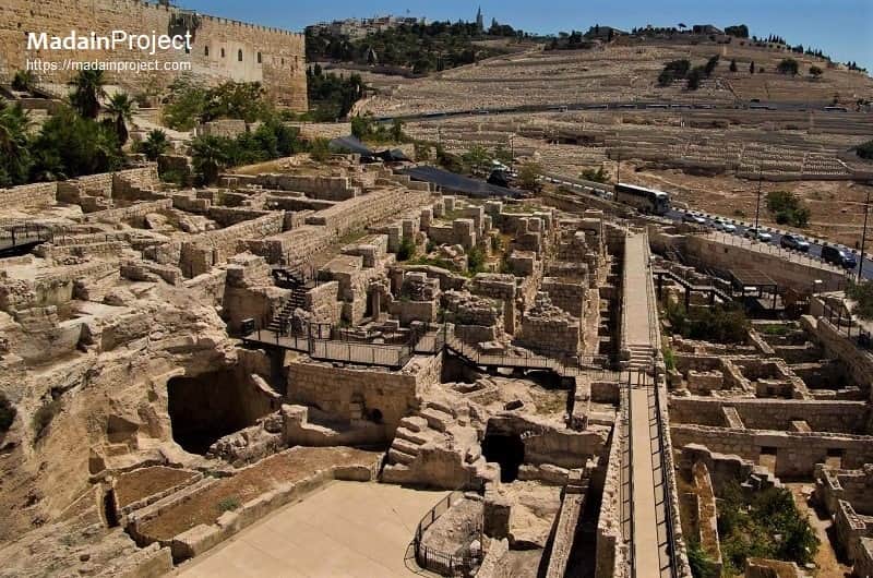
The Jerusalem Ophel, looking towards the Solomon's Stables and the Southern Wall. The Ophel is part of the Eastern Hill that sits between the City of David and the Temple Mount. The word “ophel” means “swell or rise” and refers to a higher part of the landscape. The Jebusites built their citadel there, as did David, who also added a lot more fortification to this northern part of his city.
circa 780 CE
Mosque of Omar
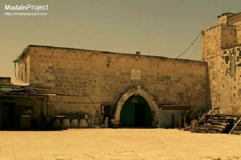
This is believed to be the location of original mosque of Omer, initially a small wooden structure was built here, along the southern wall of Haram al-Sharif (Temple Mount) and eastern wall of al-Aqsa.
circa 780 CE
Umayyad Palace
The remains of an Umayyad era Palace was discovered in the south-western area of the Temple Mount. It was obviously the seat of the Umayyad caliph whenever he visited Jerusalem. This palace measures 96 x 84 m. and is surrounded by a three meter-thick protective wall. pparently constructed during the reign of the Umayyad caliph El-Walid I (705-715) and is similar to other fortified Umayyad palaces on the fringe of the desert in Transjordan and Syria.
circa 780 CE
Southern Fortification
Interior of the southern tower (believed to the built by Fatimids) provided direct access to the Haram al-Sharif area from the residential and adminstrative area along the southern wall. The lower part of this Fatimid era tower is where now the Library al-Khatuniyya is located. Probably established by Salahuddin al-Ayubi and has remained in use ever since.
circa 780 CE
Hadrian's Inscription
Hadrian's inscription, the upside down inscription is from the Roman statue of Emperor Antoninus Pius (138-161 CE) that the Bordeaux Pilgrim recorded seeing when he was on the Temple Mount in 333 CE. The statue was destroyed by the Byzantine Christians after 333 CE, the Jews in 614 CE. This reused block is the only part found so far of the two statues (one of Hadrian, and this one of Antoninus Pius).
circa 780 CE
Huldah Gates
The Huldah Gates, are the two sets of now-blocked gates in the Southern Wall of the Temple Mount. The western set is a double arched, and the eastern is a triple arched gate. Other than two Huldah gates there's another crusader era gate, which is now blocked. Today the double (western) Huldah Gates form the basement of the Masjid al-Aqsa, known as al-Aqsa al-Qadeemi (the old al-Aqsa) and triple (eastern) Gates form part of the Masjid al-Marwani.
circa 780 CE
Single Gate
The crusader era gate (now walled up), was cut by the Knights Templar and is not original to the Temple Mount. The Crusaders used this gate to access the caverns below the Temple Mount, where they kept their horses. The gate was blocked shut by Saladin in 1187 when the Muslims returned. Also known as the Single Gate, it was repaired by the Mamelukes. It can be seen at the southern end of the sixth row of pillars, from the east, and the Triple Gate is at the south end of the twelfth row; it is clearly visible from outside the wall.
circa 780 CE
al-Aqsa Mosque Library
The al-Aqsa Mosque Library, originally it was built by crusaders as an annex building and later it was converted in to a small prayer area after Salah al-Din. It was called White mosque due to the colour of the stone used, it was majorly used by women. Recently it was converted in to a Library. The Women's Mosque is divided into three sections: the first one is attached to the Islamic Museum, the second is in the center, where the main library is located, and the third is adjacent to the al-Aqsa mosque.
circa 1278 CE
al-Fakhariyya Minaret
The al-Fakhariyya minaret is located on the sout-west corner of Masjid il-Aqsa. It was built under the supervision of Sharif al-Din Abd al-Rahman on the orders of Mamluk sulkat Lajin, and was named after Fakhar al-Din al-Khalili father of building supervisor. It is built in traditional Syrian style. At 23-meters high it is the shortest minaret inside Masjid al-Aqsa and stands without any foundations.
circa 780 CE
South Steps
An enormous flight of steps leads to the Southern Wall from the south. The 210 feet wide southern stairs are a combination of smooth stone slabs and carved bedrock and alternate between a 35 inch run (the length of the step) and a 12 inch run, except for the first and last three steps, which are all 12 inches. These stairs led the pilgrims to the southern Temple Gates which led to the underground tunnels eventually emerging on to the surface of the Temple platform.
circa 780 CE
Prayer Niche of David
Located near the south-eastern corner of the Haram it is known as the Mehrab e Daud (King David). It was renewed in the Fatimid era - during the reign of the Caliph al-Zaher to the glory of the religion of Allah - and was renewed again during the reign of the Mamluk Sultan Hossamuddin Lajjin. It is a large mehrab, without any ornamentations, built in to the souther wall of Haram al-Sharif (Temple Mount).
circa 10 CE
Cradle of Jesus
The cradle of Jesus is a stone alcove in the floor in the south-eastern corner of the court at the entrance to Solomon’s Stables. The name "Jesus' Cradle" indicates that this location was considered holy by the Christians and it is possible that here stood a church.
See Also
References
- Al-Ratrout, H. A., The Architectural Development of Al-Aqsa Mosque in the Early Islamic Period, ALMI Press, London, 2004.
- Shanks, Hershel (1995). Jerusalem, an Archaeological Biography. Random House. pp. 141–151. ISBN 978-0-679-44526-5.
- The Archaeology of the Holy Land: From the Destruction of Solomon's Temple to the Muslim Conquest, Cambridge University Press, Jodi Magness, page 355
- Moshe, Janet Mendelsohn (June 1, 2001). "Walking through Jerusalem 2,000 Years Ago". Israeli Ministry of Foreign Affair, Israel Magazine-On-Web.
- Mazar, Eilat (2002). The Complete Guide to the Temple Mount Excavations. Jerusalem: Shoham Academic Research and Publication. pp. 55–57. ISBN 978-965-90299-1-4.
- Har-El, Menashe (2004). Golden Jerusalem. Gefen Publishing House. pp. 228–242. ISBN 978-965-229-254-4.
- Rubinstein, Danny (September 12, 2004). "Remnants of the Temple?, Not in this Garbage". Haaretz.
- "Umayyad Administration Center and Palaces". Ministry of Foreign Affairs, Archaeological Sites in Israel. July 29, 1998.
- "Lailat al Miraj". BBC News. BBC MMVIII. Retrieved 29 June 2008.
- Schieck, Robert (2008) in Geographical Dimension of Islamic Jerusalem, Cambridge Scholars Publishing; see also Omar, Abdallah (2009) al-Madkhal li-dirasat al-Masjid al-Aqsa al-Mubarak, Beirut: Dar al-Kotob al-Ilmiyaah; also by the same author the Atlas of Al-Aqsa Mosque (2010)
- Tim Marshall (4 July 2017). A Flag Worth Dying For: The Power and Politics of National Symbols. Simon and Schuster. pp. 151–. ISBN 978-1-5011-6833-8.
- Elad, Amikam. (1995). Medieval Jerusalem and Islamic Worship Holy Places, Ceremonies, Pilgrimage BRILL, pp. 29–43. ISBN 90-04-10010-5.


