The role of latitude in mobilism debates - PubMed (original) (raw)
The role of latitude in mobilism debates
Edward Irving. Proc Natl Acad Sci U S A. 2005.
Abstract
In the early 1920s, the continental displacement theory of Wegener, latitude studies of Koppen and Wegener, and Argand's ideas on mountain building led to the first mobilistic paleogeography. In the 1930s and 1940s, many factors caused its general abandonment. Mobilism was revived in the 1950s and 1960s by measurements of long-term displacement of crustal blocks relative to each other (tectonic displacement) and to Earth's geographic pole (latitudinal displacement). Also, short-term or current displacements can now be measured. I briefly outline the categories of tectonic and current displacement and focus on latitudinal displacement. Integration of tectonic and latitudinal displacement in the early 1970s completed the new mobilistic paleogeography, in which the transformation of rock magnetization directions into paleopoles and latitudes and the finite rotation of spherical plates about pivot points play complementary roles; this new synthesis now provides a quantitative basis for studying long-term evolution of Earth's surface features and climate, the changing environments in which life evolves.
Figures
Fig. 1.
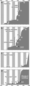
Three categories of displacements and general opinion are shown. The ordinate shows the subjective measure of increasing understanding, and the upwardly convex segments connect key discoveries and formulations. (a) Tectonic displacement. T1, general theory of continental drift introduced in refs. and ; T2, Pangea A1 and its fragmentation (–10); T3, mountain-building by continental collision (5); T4, stratigraphic and biogeographic evidence favorable to mobilism accumulates (11); T5, each continent has its own APW path (–18); T6, seafloor spreading (19); T7, oceanic displacement measurements (compiled in ref. 20); T8, plate tectonics (–23); and T9, regional plate syntheses. (b) Latitudinal displacement. L1, climate indicator proxies for latitude (24); L2, paleoclimatic and biogeographic evidence favorable to mobilism accumulates (11); L3, GAD hypothesis, APW, and latitudes (–18, 25); L4, regional concordance and global discordance of paleoclimates and paleomagnetic latitudes (17); L5, beginnings of the new paleogeography, applications to paleoclimatology, biogeography, and continental reconstructions (26, 27); L6, very large displacements and rotations in mountain belts (–31); L7, marriage of APW with plate tectonics (M), beautiful constructs (32, 33); and L8, new paleogeographic synthesis radiates. (c) Current displacement. C1, early failures; C2, very long-base interferometry; C3, laser-ranging; and C4, seismic and global positioning system (GPS) campaigns and networks. (d) General opinion. OP1, continental drift introduced; OP2, fixism entrenched; OP3, continental paleomagnetism and APW; OP4, oceanic displacements; OP5, plate tectonics.
Fig. 2.
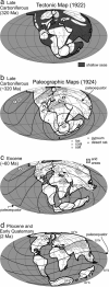
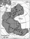
Tectonic and paleogeographic maps compared. (a) Wegener's Pangea A1 with its arbitrary grid (9, 10). (b_–_d) Wegener's maps with paleoclimatically determined latitudes superimposed by Köppen and Wegener (24); NP, north geographic pole; SP, south geographic pole; DT, Deccan Traps with paleomagnetically determined latitude (see text); sst., sandstones.
Fig. 3.
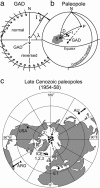
Geocentric axial dipole field confirmed for later Cenozoic time. (a) Time-averaged, occasionally reversing GAD field inclination (I) and latitude (λ). When the field reverses in polarity, the arrows denoting field at the surface also reverse. (b) N, the present geographic pole; D, declination of time-averaged field at sampling locality; I, inclination of time-averaged field at sampling locality S. When a continent moves, the field is directed along an oblique axis emergent at paleopole P. The triangle NSP can be solved and P can be determined. D is the total rotation of S relative to the present meridian. The change in latitude is the difference between the distance from S to P and from N to P. (c) Key Late Cenozoic paleopoles establishing the GAD hypothesis in the 1950s. Errors (P = 0.05) are given in square brackets. (i) Iceland lavas (24): ICE 1, ≈10 Ma [10°]; ICE 2, ≈2 Ma [12°]; ICE 3, <5,000 years ago [12°]; (ii) Mount Etna lavas (40): ET, 2,400 years ago [7°]; (iii) Newer Volcanics, Victoria, Australia (41): AU, <4 Ma [6°]; (iv) Neuquen lavas, Argentina (42): ARG, ≈5 Ma [7°]; and (v) Columbia River basalts, United States (43): USA, ≈10 Ma [12°]. The mean of these seven poles is latitude 89°N, longitude 118°E, error = 3° (P = 0.05), precision K = 461 and circular standard deviation (CSD) = 4°.
Fig. 4.
APW paths in 1958 were mainly Carboniferous and younger. Earlier Paleozoic results from Europe and North America are shown; complex results from Australia are not. Africa: JK, Jurassic Karroo lavas (59, 60). Australia: C–K, Late Carboniferous through Cretaceous; LT, Paleogene (41). Europe: Cb, Cambrian; D, Devonian; P, Permian; Tr, Triassic (12). India: R, Rahajmahal Traps (61); DT, Early Cenozoic Deccan Traps (17, 62). North America: S, Silurian; C–Tr, Carboniferous through Triassic; K, Cretaceous (16). South America: SG, Jurassic Serra Geral volcanics (42).
Fig. 5.
Contradictions arise when Permian paleolatitudes (dark lines) determined from Europe are extended across fixed continents. NP, north pole of present geographic grid; C, carbonates; R, desert sandstones; E, evaporites; G, glacial strata (26). This figure is reproduced with permission from ref. (copyright 1956, Birkhäuser, Basel).
Fig. 6.
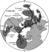
A beautiful construct integrating plate tectonics and paleomagnetically determined latitude. Early Jurassic geographic grid of the larger map (68, 70) constructed from paleopoles (Inset) for major crustal blocks rotated with continents (71). E, Europe; G, Gondwana (data combined from Australia, Africa, South America, and Antarctica); NA, North America.
Fig. 7.
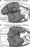
Intra-Pangean megashear. In this interpretation the transition from Pangea B to Pangea A2 is Permian, and the transition from Pangea A2 to Pangea A1 is Triassic. [Reprinted with permission from ref. (Copyright 2003, Elsevier).]
Fig. 8.
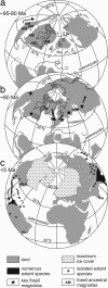
Distribution of magnolias at three intervals. (a) Ancestral magnolia (AM) fossils. (b) Proposed eastward migration out of North America during the Eocene supergreenhouse, then later to east Asia, with key fossil localities for the time interval 60–15 Ma indicated by stars. Land-bridges are Beringia (BE), deGeer (DG), and Thulean (TH). (c) Disjunctive populations caused by southerly migration in response to global cooling. IP, Isthmus of Panama. [Simplified with permission from ref. (Copyright 2004, American Geophysical Union).]
Fig. 9.
Precambrian latitudes of western Laurentia 1,950–1,850 Ma (79). The bold arrow indicates inferred wind direction (80, 81). C, carbonate rocks; E, evaporites; R, redbeds with sequential reversals; THO, TransHudson mountain belt.
Comment in
- Biography of Edward Irving.
Davis TH. Davis TH. Proc Natl Acad Sci U S A. 2005 Feb 8;102(6):1819-20. doi: 10.1073/pnas.0407301101. Epub 2005 Jan 31. Proc Natl Acad Sci U S A. 2005. PMID: 15684059 Free PMC article. No abstract available.
Similar articles
- The evolution of the Earth.
Allegre CJ, Schneider SH. Allegre CJ, et al. Sci Am. 1994 Oct;271(4):66-71, 74-5. doi: 10.1038/scientificamerican1094-66. Sci Am. 1994. PMID: 11536645 - Long-term stability of the Earth's climate.
Kasting JF. Kasting JF. Glob Planet Change. 1989;75:83-95. Glob Planet Change. 1989. PMID: 11539789 - Initiation of clement surface conditions on the earliest Earth.
Sleep NH, Zahnle K, Neuhoff PS. Sleep NH, et al. Proc Natl Acad Sci U S A. 2001 Mar 27;98(7):3666-72. doi: 10.1073/pnas.071045698. Epub 2001 Mar 20. Proc Natl Acad Sci U S A. 2001. PMID: 11259665 Free PMC article. - The role of biology in planetary evolution: cyanobacterial primary production in low-oxygen Proterozoic oceans.
Hamilton TL, Bryant DA, Macalady JL. Hamilton TL, et al. Environ Microbiol. 2016 Feb;18(2):325-40. doi: 10.1111/1462-2920.13118. Epub 2015 Dec 21. Environ Microbiol. 2016. PMID: 26549614 Free PMC article. Review. - Impact process: an important geological phenomenon.
Skala R. Skala R. Sb Nar Muz Praze Rada B. 1996;52(1-4):111-56. Sb Nar Muz Praze Rada B. 1996. PMID: 11541230 Review.
Cited by
- Biography of Edward Irving.
Davis TH. Davis TH. Proc Natl Acad Sci U S A. 2005 Feb 8;102(6):1819-20. doi: 10.1073/pnas.0407301101. Epub 2005 Jan 31. Proc Natl Acad Sci U S A. 2005. PMID: 15684059 Free PMC article. No abstract available. - Symbiogenesis, natural selection, and the dynamic Earth.
Kutschera U. Kutschera U. Theory Biosci. 2009 Aug;128(3):191-203. doi: 10.1007/s12064-009-0065-0. Epub 2009 Apr 28. Theory Biosci. 2009. PMID: 19399544
References
- Eiseley, L. (1975) All the Strange Hours: The Excavation of a Life (Scribner's Sons, New York), p. 186.
- Darwin, C. (1987) Charles Darwin's Notebooks, 1836–1844: Geology, Transmutation of Species, Metaphysical Enquiries, eds. Barrett, P. H., Gautrey, P. J., Herbert, S., Kohn, D. & Smith, S. (Cornell Univ. Press, Ithaca, NY).
- Gilbert, W. (1600) De Magnete (Chiswick, London); trans. Mottely, P. F. (1958) (Dover, New York).
- Argand, E. (1924) Congr. Geol. Int. 8, 171–372; trans. Carrozzi, A. V. (1977) Tectonics of Asia (Hafner, New York).
MeSH terms
LinkOut - more resources
Full Text Sources
