Natural versus anthropogenic subsidence of Venice - PubMed (original) (raw)
Comparative Study
Natural versus anthropogenic subsidence of Venice
Luigi Tosi et al. Sci Rep. 2013.
Abstract
We detected land displacements of Venice by Persistent Scatterer Interferometry using ERS and ENVISAT C-band and TerraSAR-X and COSMO-SkyMed X-band acquisitions over the periods 1992-2010 and 2008-2011, respectively. By reason of the larger observation period, the C-band sensors was used to quantify the long-term movements, i.e. the subsidence component primarily ascribed to natural processes. The high resolution X-band satellites reveal a high effectiveness to monitor short-time movements as those induced by human activities. Interpolation of the two datasets and removal of the C-band from the X-band map allows discriminating between the natural and anthropogenic components of the subsidence. A certain variability characterizes the natural subsidence (0.9 ± 0.7 mm/yr), mainly because of the heterogeneous nature and age of the lagoon subsoil. The 2008 displacements show that man interventions are responsible for movements ranging from -10 to 2 mm/yr. These displacements are generally local and distributed along the margins of the city islands.
Figures
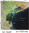
Figure 1. Velocity map (mm/yr) for the Venice coastland obtained by IPTA on ENVISAT images acquired between 2003 and 2010.
Positive values mean uplift, negative land subsidence. White triangles show the position of the permanent GPS stations (CGPS). Base map used is a Landsat image obtained from the US Geological Survey – Earth Resources Observation and Science (EROS) Center and composed in ESRI ArcMAP 9.3.
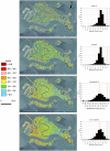
Figure 2
Average displacement rates (mm/yr) obtained by IPTA at Venice: (a) ERS from 1992 to 2002; (b) ENVISAT from 2003 to 2010; (c) TerraSAR-X from March 2008 and January 2009; (d) COSMO-SkyMed from 2008 to 2011. The image background is an aerophotograph acquired in 2009. Negative values indicate settlement, positive mean uplift. The frequency distribution of the displacements for each map is provided to the right. The red lines separate the subsiding (<−1 mm/yr), stable (between −1 and 1 mm/yr), and uplifiting (>1 mm/yr) portions. Figure composed in ESRI ArcMAP 9.3.
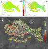
Figure 3
Maps of the displacement rate (positive velocities indicate site uplift, negative velocities indicate land subsidence) obtained by interpolating: (a) the ERS-ENVISAT and (b) the TerraSAR-X IPTA results on a regular 50 m grid. (c) Difference between the TerraSAR-X and ERS-ENVISAT maps representing an estimate of the present anthropogenic land movements at Venice. Negative and positive rates indicate areas where human activities are responsible for land settlements or reduce the natural subsidence, respectively. The light-blue box in (c) refers to the area investigated in Fig. 5. Maps composed in Golden Software Surfer 10.
Figure 4
(a) Architecture of the shallow subsoil of Venice along the alignment A–D. The location of the geological data is shown in the inset. The satellite image is from Google Earth, data source: Landsat, 2013 Digital Globe, and European Space Imaging. (b) Growth in area of Venice from 900 A.D. to present.
Figure 5. Example of temporary high sinking rates due to restoration works of single palaces.
Average displacement rates (mm/yr) obtained by IPTA at a portion of the city NE of St. Mark's Basilica: (a) ERS, (b) ENVISAT, (c) TerraSAR-X, and (d) COSMO-SkyMed. The picture comparison highlights how the short-term analysis performed with the TerraSAR-X images (c) captures the effect of the works carried out in 2007 (see the corresponding aerial photograph shown in the inset). The longer time series acquired by C-band sensors (a and b) show that before 2007 the area was affected by the natural subsidence only (~1 mm/yr). After the end of the works, the average rates reduce following the consolidation process, as detected by COSMO-SkyMed. Figure composed in ESRI ArcMAP 9.3.
Figure 6. Data validation.
Comparison between the displacement histories recorded by the (a) TREV, (b) MARG, (c) CAVA, (d) SFEL CGPS and those obtained by IPTA on the persistent reflectors in the nearby of the permanent stations.
Similar articles
- Sentinel-1A for monitoring land subsidence of coastal city of Pakistan using Persistent Scatterers In-SAR technique.
Hussain MA, Chen Z, Shoaib M, Shah SU, Khan J, Ying Z. Hussain MA, et al. Sci Rep. 2022 Mar 28;12(1):5294. doi: 10.1038/s41598-022-09359-7. Sci Rep. 2022. PMID: 35351954 Free PMC article. - Land subsidence in the Friuli Venezia Giulia coastal plain, Italy: 1992-2010 results from SAR-based interferometry.
Da Lio C, Tosi L. Da Lio C, et al. Sci Total Environ. 2018 Aug 15;633:752-764. doi: 10.1016/j.scitotenv.2018.03.244. Epub 2018 Mar 28. Sci Total Environ. 2018. PMID: 29602114 - Analysis of building deformation in landslide area using multisensor PSInSAR™ technique.
Ciampalini A, Bardi F, Bianchini S, Frodella W, Del Ventisette C, Moretti S, Casagli N. Ciampalini A, et al. Int J Appl Earth Obs Geoinf. 2014 Dec;33:166-180. doi: 10.1016/j.jag.2014.05.011. Int J Appl Earth Obs Geoinf. 2014. PMID: 28413370 Free PMC article. - Monitoring land subsidence in the Peshawar District, Pakistan, with a multi-track PS-InSAR technique.
Hussain MA, Chen Z, Khan J. Hussain MA, et al. Environ Sci Pollut Res Int. 2024 Feb;31(8):12271-12287. doi: 10.1007/s11356-024-31995-x. Epub 2024 Jan 17. Environ Sci Pollut Res Int. 2024. PMID: 38231332
Cited by
- Modeling the two- and three-dimensional displacement field in Lorca, Spain, subsidence and the global implications.
Fernandez J, Prieto JF, Escayo J, Camacho AG, Luzón F, Tiampo KF, Palano M, Abajo T, Pérez E, Velasco J, Herrero T, Bru G, Molina I, López J, Rodríguez-Velasco G, Gómez I, Mallorquí JJ. Fernandez J, et al. Sci Rep. 2018 Oct 3;8(1):14782. doi: 10.1038/s41598-018-33128-0. Sci Rep. 2018. PMID: 30283152 Free PMC article. - Assessing the human footprint on the sea-floor of coastal systems: the case of the Venice Lagoon, Italy.
Madricardo F, Foglini F, Campiani E, Grande V, Catenacci E, Petrizzo A, Kruss A, Toso C, Trincardi F. Madricardo F, et al. Sci Rep. 2019 Apr 29;9(1):6615. doi: 10.1038/s41598-019-43027-7. Sci Rep. 2019. PMID: 31036875 Free PMC article. - New evidence of a Roman road in the Venice Lagoon (Italy) based on high resolution seafloor reconstruction.
Madricardo F, Bassani M, D'Acunto G, Calandriello A, Foglini F. Madricardo F, et al. Sci Rep. 2021 Jul 22;11(1):13985. doi: 10.1038/s41598-021-92939-w. Sci Rep. 2021. PMID: 34294742 Free PMC article. - Climatology and process-oriented analysis of the Adriatic sea level extremes.
Šepić J, Pasarić M, Međugorac I, Vilibić I, Karlović M, Mlinar M. Šepić J, et al. Prog Oceanogr. 2022 Dec;209:None. doi: 10.1016/j.pocean.2022.102908. Prog Oceanogr. 2022. PMID: 36518908 Free PMC article. - Modeling of land subsidence using GIS-based artificial neural network in Yunlin County, Taiwan.
Ku CY, Liu CY. Ku CY, et al. Sci Rep. 2023 Mar 11;13(1):4090. doi: 10.1038/s41598-023-31390-5. Sci Rep. 2023. PMID: 36906692 Free PMC article.
References
- Fontes J. & Bortolami G. Subsidence of the Venice area during the past 40,000 yr. Nature 244, 339–341 (1977).
- Bortolami G. C., Fontes J. C., Markgraf V. & Saliege J. F. Land, sea and climate in the northern Adriatic region during late Pleistocene and Holocene. Palaeogeogr. Palaeoclimatol. Palaeoecol. 21, 139–156 (1977).
- Carminati E. & Di Donato G. Separating natural and anthropogenic vertical movements in fast subsiding areas: the Po plain (N. Italy) case. Geophys. Res. Lett. 26, 2291–2294 (1999).
- Kent V. D., Rio D., Massari F., Kukla G. & Lanci L. Emergence of Venice during the Pleistocene. Quat. Sci. Rev. 21, 1719–1727 (2002).
- Carminati E., Doglioni C. & Scrocca D. Apennines subduction-related subsidence of Venice. Geophys. Res. Lett. 30, 1717 (2003).
Publication types
MeSH terms
LinkOut - more resources
Full Text Sources
Other Literature Sources


