Impacts of 25 years of groundwater extraction on subsidence in the Mekong delta, Vietnam - PubMed (original) (raw)
Impacts of 25 years of groundwater extraction on subsidence in the Mekong delta, Vietnam
P S J Minderhoud et al. Environ Res Lett. 2017.
Abstract
Many major river deltas in the world are subsiding and consequently become increasingly vulnerable to flooding and storm surges, salinization and permanent inundation. For the Mekong Delta, annual subsidence rates up to several centimetres have been reported. Excessive groundwater extraction is suggested as the main driver. As groundwater levels drop, subsidence is induced through aquifer compaction. Over the past 25 years, groundwater exploitation has increased dramatically, transforming the delta from an almost undisturbed hydrogeological state to a situation with increasing aquifer depletion. Yet the exact contribution of groundwater exploitation to subsidence in the Mekong delta has remained unknown. In this study we deployed a delta-wide modelling approach, comprising a 3D hydrogeological model with an integrated subsidence module. This provides a quantitative spatially-explicit assessment of groundwater extraction-induced subsidence for the entire Mekong delta since the start of widespread overexploitation of the groundwater reserves. We find that subsidence related to groundwater extraction has gradually increased in the past decades with highest sinking rates at present. During the past 25 years, the delta sank on average ∼18 cm as a consequence of groundwater withdrawal. Current average subsidence rates due to groundwater extraction in our best estimate model amount to 1.1 cm yr-1, with areas subsiding over 2.5 cm yr-1, outpacing global sea level rise almost by an order of magnitude. Given the increasing trends in groundwater demand in the delta, the current rates are likely to increase in the near future.
Keywords: Delta subsidence; Imod; groundwater exploitation; modelling; sea-level rise.
Figures
Figure 1.
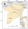
Location of the Mekong Delta and part of the interconnected Saigon River to the northeast, encompassing the province of Ho Chi Minh City, in the south of Vietnam. The map extent corresponds with the model extent. Cross-section line A-A’ shows the location of the hydrogeological cross-section in figure 2.
Figure 2.
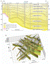
(a) Hydrogeological cross-section with the interpretation of the deltas subsurface aquifer-system identifying the main units according to the Division of Geological Mapping for the South of Vietnam (modified after DGMS 2004). Each unit consists of a permeable bottom layer (aquifer) and an, occasionally discontinuous, confining top layer (aquitard). (b) Ten hydrogeological cross-sections distinguishing aquifers and aquitards used to create the 3D subsurface model, by linear interpolation, of the MKD. The cross-sections are linearly extrapolated into the sea and cross-border to reach the model boundary 50 km offshore and 20 km outside the national border.
Figure 3.
Annual modelled groundwater extraction in the MKD and HCMC province. An annual increase of 2.5% is assumed for extraction in the MKD after 2011. The dots (Le and Nguyen 2010 in Minh et al 2015) and triangle (Thoang and Giao 2015) show alternative values reported for HCMC province.
Figure 4.
Modelled aquifer drawdown at the start of 2016 after 25 years of simulated groundwater extraction for in the seven main aquifers of the MKD (see figure 2(a)). The deeper aquifers do not extend over the entire delta. Cities located in the figure: BL: Bac Lieu; CM: Ca Mau; CT: Can Tho; HCMC: Ho Chi Minh City; ST: Soc Trang; TA: Tan An.
Figure 5.
Sensitivity analysis of modelled subsidence to overconsolidation ratio. The range of OCR values of 1.45–1.75 represents the determined least to most conservative subsidence model. The model using an OCR of 1.63 has the highest correlation with the average InSAR-measured subsidence for the entire MKD (calculated from the Erban et al 2014) and is selected as the best estimate model. Rates are all average annual value over the period 2006–2010.
Figure 6.
(a) Modelled cumulative subsidence due to groundwater extraction-induced during 25 years of groundwater exploitation from 1991 to 2016. (b) Modelled groundwater extraction-induced annual subsidence rates for 2015.
Figure 7.
(i)-(v) Annual groundwater extraction-induced subsidence rates for each five year period. Monitoring well locations are marked alphabetically. (a)-(h) Modelled and measured hydraulic head time series at monitoring well locations. Cumulative calculated subsidence is shown in red. The periodic fluctuations in the subsidence graphs reflect the elastic response up to 2 cm to seasonal wetting and drying as the aquifer system expands and shrinks. The red dots represent InSAR-measured subsidence rates over 2006–2010 by Erban et al (2014) for visual comparison.
Figure 8.
(a) InSAR-measured subsidence (after Erban et al 2014, data © JAXA, METI 2011). Rectangles show selected subsets for comparison. A: Long Xuyen; B: Cao Lahn C: Tan An; D: Rach Gia; E: Can Tho province; F: Can Tho; G: Vinh Long province; H: My Tho; I: Ca Mau; J: Bac Lieu province; K: Soc Trang; L: Tra Vinh province. (b) Modelled subsidence of the best estimate model (OCR:1.63). (c) Fit between modelled subsidence rates and InSAR measurements for the selected subsets showing average values (green dots) with one standard deviation (σ). The linear fit trend line (y = 1.0x) of the best estimate model and respectively the least and most conservative models are shown (data points are not shown). All rates are in annual averages over the period 2006–2010.
Similar articles
- The role of sedimentation and natural compaction in a prograding delta: insights from the mega Mekong delta, Vietnam.
Zoccarato C, Minderhoud PSJ, Teatini P. Zoccarato C, et al. Sci Rep. 2018 Jul 30;8(1):11437. doi: 10.1038/s41598-018-29734-7. Sci Rep. 2018. PMID: 30061593 Free PMC article. - Release of arsenic to deep groundwater in the Mekong Delta, Vietnam, linked to pumping-induced land subsidence.
Erban LE, Gorelick SM, Zebker HA, Fendorf S. Erban LE, et al. Proc Natl Acad Sci U S A. 2013 Aug 20;110(34):13751-6. doi: 10.1073/pnas.1300503110. Epub 2013 Aug 5. Proc Natl Acad Sci U S A. 2013. PMID: 23918360 Free PMC article. - Changing sediment budget of the Mekong: Cumulative threats and management strategies for a large river basin.
Kondolf GM, Schmitt RJP, Carling P, Darby S, Arias M, Bizzi S, Castelletti A, Cochrane TA, Gibson S, Kummu M, Oeurng C, Rubin Z, Wild T. Kondolf GM, et al. Sci Total Environ. 2018 Jun 1;625:114-134. doi: 10.1016/j.scitotenv.2017.11.361. Epub 2017 Dec 27. Sci Total Environ. 2018. PMID: 29288998 - Environmental pressures on livelihood transformation in the Vietnamese Mekong Delta: Implications and adaptive pathways.
Tran DD, Park E, Wang J, Loc HH, Lee J, Zhan S, Kantoush SA. Tran DD, et al. J Environ Manage. 2025 Mar;377:124597. doi: 10.1016/j.jenvman.2025.124597. Epub 2025 Feb 25. J Environ Manage. 2025. PMID: 40010276 Review. - Sand mining in the Mekong Delta: Extent and compounded impacts.
Park E. Park E. Sci Total Environ. 2024 May 10;924:171620. doi: 10.1016/j.scitotenv.2024.171620. Epub 2024 Mar 10. Sci Total Environ. 2024. PMID: 38467261 Review.
Cited by
- The role of sedimentation and natural compaction in a prograding delta: insights from the mega Mekong delta, Vietnam.
Zoccarato C, Minderhoud PSJ, Teatini P. Zoccarato C, et al. Sci Rep. 2018 Jul 30;8(1):11437. doi: 10.1038/s41598-018-29734-7. Sci Rep. 2018. PMID: 30061593 Free PMC article. - Seasonal and inter-annual drivers of yellow fever transmission in South America.
Hamlet A, Gaythorpe KAM, Garske T, Ferguson NM. Hamlet A, et al. PLoS Negl Trop Dis. 2021 Jan 11;15(1):e0008974. doi: 10.1371/journal.pntd.0008974. eCollection 2021 Jan. PLoS Negl Trop Dis. 2021. PMID: 33428623 Free PMC article. - The relation between land use and subsidence in the Vietnamese Mekong delta.
Minderhoud PSJ, Coumou L, Erban LE, Middelkoop H, Stouthamer E, Addink EA. Minderhoud PSJ, et al. Sci Total Environ. 2018 Sep 1;634:715-726. doi: 10.1016/j.scitotenv.2018.03.372. Epub 2018 Apr 9. Sci Total Environ. 2018. PMID: 29649716 Free PMC article. - Delta Subsidence: An Imminent Threat to Coastal Populations.
Schmidt CW. Schmidt CW. Environ Health Perspect. 2015 Aug;123(8):A204-9. doi: 10.1289/ehp.123-A204. Environ Health Perspect. 2015. PMID: 26230277 Free PMC article. No abstract available. - Tidal amplification and salt intrusion in the Mekong Delta driven by anthropogenic sediment starvation.
Eslami S, Hoekstra P, Nguyen Trung N, Ahmed Kantoush S, Van Binh D, Duc Dung D, Tran Quang T, van der Vegt M. Eslami S, et al. Sci Rep. 2019 Dec 10;9(1):18746. doi: 10.1038/s41598-019-55018-9. Sci Rep. 2019. PMID: 31822705 Free PMC article.
References
- Abidin HZ, Andreas H, Gumilar I, Fukuda Y, Pohan YE and Deguchi T 2011. Land subsidence of Jakarta (Indonesia) and its relation with urban development Nat. Hazards 59 1753–71
- van Asselen S, Stouthamer E and Van Asch T W J 2009. Earth-science reviews effects of peat compaction on delta evolution: a review on processes, responses, measuring and modeling Earth Sci. Rev 92 35–51
- Bakr M, de Lange G and Toan DN 2013. Ho Chi Minh City flood and inundation management Final Report, Volume 2: IFRM Strategy, Annex 3: Land Subsidence—Royal Haskoning-DHV and Deltares vol 3
- Bell AL 1977. A geotechnical investigation of post-glacial estuarine deposits at Kinnegar, Belfast Lough PhD thesis (Belfast: Queen’s University; )
LinkOut - more resources
Full Text Sources
Research Materials
Miscellaneous


