Governing Tripolye: Integrative architecture in Tripolye settlements - PubMed (original) (raw)
Governing Tripolye: Integrative architecture in Tripolye settlements
Robert Hofmann et al. PLoS One. 2019.
Abstract
Recently, high-resolution magnetometry surveys have led to the discovery of a special category of buildings-so-called 'mega-structures'-situated in highly visible positions in the public space of Tripolye giant-settlements of the late 5th and first half of the 4th millennium BCE. In this paper we explore what these buildings actually are and how they can contribute to the understanding of the development of social space in Tripolye giant-settlements. For this investigation, we linked newly obtained excavation data from the giant-settlement Maidanetske, Ukraine, with a much larger sample of such buildings from magnetic plans obtained in the region between the Carpathian foothills and the Dnieper River. Accordingly, Tripolye mega-structures represent a particular kind of integrative building documented in many non-ranked ethnographic contexts. Based on our results we are interpreting that these buildings were used for various ritual and non-ritual activities, joint decision-making, and the storage and consumption of surplus. In Tripolye giant-settlements at least three different categories of mega-structures could be identified which most likely represent different levels of socio-political integration and decision-making. The emergence of this hierarchical system of high-level integrative buildings for the whole community and different low-level integrative architectures for certain segments of local communities was related to the rise of Tripolye mega-sites. The presence of different integrative levels most likely reflects the fusion of different previously independent communities in the giant-settlements. Later in the mega-site development, we observe how low-level integrative buildings increasingly lose their importance indicated by shrinking size and, finally, their disappearance. This observation might indicate that the power which was previously distributed across the community was transferred to a central institution. It is argued that the non-acceptance of this concentration of power and the decline of lower decision-making levels might be a crucial factor for the disintegration of Tripolye giant-settlements around 3600 BCE.
Conflict of interest statement
The authors have declared that no competing interests exist.
Figures
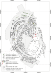
Fig 1. Maidanetske.
Redrawing of the plan of the magnetic survey (Adapted and extended for publication after Fig 22a of [7] under CC BY licence with permission from the Institute of Pre- and Protohistoric Archaeology, Kiel University, Germany). Green buildings: Dwellings of settlement Maidanetske 1. White buildings: Dwellings of settlement Maidanetske 2. Light red buildings: adjacent dwellings of the primary plaza. Red buildings: Mega-structures at the primary plaza. Yellow buildings: Mega-structures in the ring-corridor. Blue buildings: Mega-structures at different positions of radial pathways.
Fig 2. Map of sites with mega-structures analysed in this article and Tripolye periods.
Fig 3. Maidanetske.
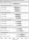
Bayesian models of 14C dates from trench 111 plotted on the calibration curve.
Fig 4. Maidanetske, trench 111, section of the magnetic plans with anomalies of mega-structure 3.
Fig 5. Maidanetske, features of the first building phase in trench 111 below mega-structure 3 with location of pits and a row of dwellings.
Fig 6. Maidanetske, trench 111, drawing of profile 32 through pit 111/3 below mega-structure 3 (location see Fig 7).
Fig 7. Maidanetske, mega-structure 3 in trench 111, drawing of daub from collapsed walls, floor, and pottery.
Fig 8. Maidanetske, weight of daub belonging to mega-structure 3 in trench 111.
Fig 9. Maidanetske, kind, dimension, and direction of timber imprints from mega-structure 3.
Fig 10. Maidanetske, profile sections through the fireplace of mega-structure 3.
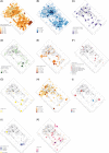
Fig 11. Maidanetske, find distributions in mega-structure 3.
(A) Ceramic fragmentation. (B) Ceramics. (C) Bowls. (D) Closed/half-closed shapes. (E) Kitchen ware. (F) Ground stone artefacts. (G) Cereal Grains. (H) Animal bones. (I) Flint artefacts. (J) Remains of textile production. (K) Stipa seeds.
Fig 12
Maidanetske, ceramic inventory of mega-structure 3: Cup (1), bowls (3–5, 7, 8), miniature vessel (2), and goblet (6).
Fig 13
Maidanetske, ceramic inventory of mega-structure 3: Biconical vessel (1), crater (3), biconical/sphero-conical vessels (4, 5), and sphero-conical vessel (2).
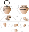
Fig 14
Maidanetske, ceramic inventory of mega-structure 3: Amphorae (1–3), pear-shaped vessel (4), pots made of kitchen ware (5–7), and pots made of table ware (8).
Fig 15. Maidanetske, reconstructed ground plan of mega-structure 3 with activity zones.
Fig 16. Maidanetske, comparison of pottery characteristics in dwellings 44 and 59 and mega-structure 3.
(A) Location of engobe, (B) Frequency of morphological vessel classes according to the count of vessel units, (C) Frequency of vessel classes according to summed rim percentages.
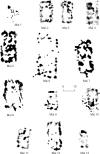
Fig 17. Maidanetske, magnetic anomalies of mega-structures 1–13.
Fig 18
Nebelivka, mega-structure, floor plans of the mega-structure (Reprinted from [59], Fig 1A under CC BY licence with permission from Editura “Constantin Matasă”, original copyright Natalia Burdo, 2014) ground floor, b) presumed upper floor, 1–7 repeatedly renewed clay platforms (for pyrotechnical processes), 8–9 clay bins with grinding stones (grinding installations), 12 Podium, 13–16 large storage vessels (capacity around 50 l each), 17–21 thresholds of passages.
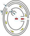
Fig 19. Schematic representation of the observed positioning of mega-structures in Tripolye settlements.
Fig 20. Hlybochok.
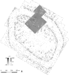
Magnetic plan of the primary plaza in the north of the settlement (Reprinted from [34], Fig 152 under CC BY licence with permission from Sidetone Press, original copyright Renè Ohlrau, 2019).
Fig 21. Scatterplot diagram of length and width of 104 special buildings from Cucuteni-Tripolye settlements between the Carpathians in the west and the Southern Bug-Dnieper Interfluve area in the east.
Mapped are the positions of the buildings within the settlements. The buildings are coded with short names which are listed in Table 2.
Fig 22
Sorting of Tripolye mega-structures by (A) length-/width-ratio, (B) division in longitudinal direction and (C) architectural characteristics and application of a type classification based on data of magnetic surveys.
Fig 23. Bar chart displaying the frequency of positioning of the different types of special buildings in Tripolye settlements.
The underlying data are available in Table 2.
Fig 24. Scatter plot of floor area and estimated maximum use group size of 104 low-level and high-level special buildings in Tripolye settlements in comparison to the ethnographic sample after [26].
The underlying data for the estimation is displayed in Table 1.
Fig 25. Boxplot diagram of floor areas of Tripolye mega-structures in a diachronic view differentiated according to positions within settlements.
The underlying data are available in Table 2.
Fig 26. Schematic reconstruction of transformation processes of political integrative institutions and architecture in Tripolye settlements.
Around 4600 BCE–In small settlements, integrative activities took place in central mega-structures. Around 4100/4000 BCE–Giant-settlements developed through the fusion of smaller communities, which maintained their integrative institutions and established high-level central institutions for the entire settlement. Around 3900/3800 BCE–Ongoing centralisation of integrative activities is indicated by increasing functional and architectural differentiation between high-level and middle-low-level integrative buildings. Around 3700 BCE–Increasing centralisation of social and political activities led to the loss of the middle-lower integrative decision-making levels. Around 3650/3500 BCE–Disintegration of Tripolye giant-settlements and re-emergence of a dispersed settlement system without (visible) integrative architecture.
Similar articles
- Isotopes prove advanced, integral crop production, and stockbreeding strategies nourished Trypillia mega-populations.
Schlütz F, Hofmann R, Dal Corso M, Pashkevych G, Dreibrodt S, Shatilo M, Terna A, Fuchs K, Videiko M, Rud V, Müller J, Kirleis W. Schlütz F, et al. Proc Natl Acad Sci U S A. 2023 Dec 26;120(52):e2312962120. doi: 10.1073/pnas.2312962120. Epub 2023 Dec 18. Proc Natl Acad Sci U S A. 2023. PMID: 38109547 Free PMC article. - Impacts of Spatial Components on Outdoor Thermal Comfort in Traditional Linpan Settlements.
Zhang L, Liu H, Wei D, Liu F, Li Y, Li H, Dong Z, Cheng J, Tian L, Zhang G, Shi L. Zhang L, et al. Int J Environ Res Public Health. 2022 May 25;19(11):6421. doi: 10.3390/ijerph19116421. Int J Environ Res Public Health. 2022. PMID: 35682007 Free PMC article. - Integrating and Dividing in a Late Bronze Age Society: Internal Organization of Settlements of the Tisza Site Group in the Southern Carpathian Basin, 1600-1200 b.c.
Bruyère C, Molloy B, Jovanović D, Birclin M, Pendić J, Topić G, Milašinović L, Mirković-Marić N, Šalamon A. Bruyère C, et al. J Field Archaeol. 2024 Jul 10;49(7):547-572. doi: 10.1080/00934690.2024.2372161. eCollection 2024. J Field Archaeol. 2024. PMID: 39381562 Free PMC article. - A comprehensive review on green buildings research: bibliometric analysis during 1998-2018.
Li Y, Rong Y, Ahmad UM, Wang X, Zuo J, Mao G. Li Y, et al. Environ Sci Pollut Res Int. 2021 Sep;28(34):46196-46214. doi: 10.1007/s11356-021-12739-7. Epub 2021 Feb 16. Environ Sci Pollut Res Int. 2021. PMID: 33594568 Free PMC article. Review. - Influences of building design and site design on physical activity: research and intervention opportunities.
Zimring C, Joseph A, Nicoll GL, Tsepas S. Zimring C, et al. Am J Prev Med. 2005 Feb;28(2 Suppl 2):186-93. doi: 10.1016/j.amepre.2004.10.025. Am J Prev Med. 2005. PMID: 15694527 Review.
Cited by
- The largest prehistoric mound in Europe is the Bronze-Age Hill of Udine (Italy) and legend linked its origin to Attila the Hun.
Fontana A, Vinci G, Ronchi L, Mocchiutti A, Muscio G, Visentini P, Bassetti M, Novellino MD, Badino F, Musina G, Bonomi S. Fontana A, et al. Sci Rep. 2023 May 31;13(1):8848. doi: 10.1038/s41598-023-35175-8. Sci Rep. 2023. PMID: 37258555 Free PMC article. - Isotopes prove advanced, integral crop production, and stockbreeding strategies nourished Trypillia mega-populations.
Schlütz F, Hofmann R, Dal Corso M, Pashkevych G, Dreibrodt S, Shatilo M, Terna A, Fuchs K, Videiko M, Rud V, Müller J, Kirleis W. Schlütz F, et al. Proc Natl Acad Sci U S A. 2023 Dec 26;120(52):e2312962120. doi: 10.1073/pnas.2312962120. Epub 2023 Dec 18. Proc Natl Acad Sci U S A. 2023. PMID: 38109547 Free PMC article.
References
- Menotti F, Korvin-Piotrovskiy AG. The Tripolye Culture Giant-Settlements in Ukraine Formation, Development and Decline. Oxford: Oxbow Books; 2012.
- Chapman J, Videiko MY, Hale D, Gaydarska B, Burdo N, Rassmann K, et al. The Second Phase of the Trypillia Mega-Site Methodological Revolution: A New Research Agenda. European Journal of Archaeology. 2014; 17(3):369–406.
- Müller J, Rassmann K, Videiko M. Trypilla Mega-Sites and European Prehistory 4100–3400 BCE London and New York: Routledge Taylor and Francis Group; 2016.
- Uhl RA, Vasilache-Curoşu M, Sîrbu M, Sîrbu L, Bicbaev V, Steiniger D, et al. Petreni in der nördlichen Moldaurepublik Bericht über die Ausgrabungen der Jahre 2011–2013. Eurasia Antiqua. 2014 (2017);20:185–206.
- Ţerna S, Rassmann K, Vasilache M, Radloff K. Stolniceni I–new research on a Cucuteni-Tripolye large site In: Zanoci A, Kaiser E, Kashuba M, Izbitser MB, editors. Mensch, Kultur und Gesellschaft von der Kupferzeit bis zur frühen Eisenzeit im nördlichen Eurasien Beiträge zu Ehren zum 60 Geburtstag von Eugen Sava Man, Culture, and Society from the Copper Age until the Early Iron Age in Northern Eurasia Contributions in Honour of the 60th Anniversary of Eugen Sava. Tyragetia International. 1. Chişinău: National Museum of History of Moldova and Freie Universität Berlin; 2016. p. 41–52.
Publication types
Grants and funding
The research was funded by the German Research Foundation (Deutsche Forschungsgemeinschaft, DFG, - Project number 2901391021 – SFB 1266). The funders had no role in study design, data collection and analysis, decision to publish, or preparation of the manuscript.
LinkOut - more resources
Full Text Sources
