Periodic Bedrock Ridges at the ExoMars 2022 Landing Site: Evidence for a Changing Wind Regime - PubMed (original) (raw)
. 2021 Feb 28;48(4):e2020GL091651.
doi: 10.1029/2020GL091651. Epub 2021 Feb 22.
A Pacifici 3, F Salese 4 3, D A Vaz 5, A Neesemann 6, D Tirsch 7, C I Popa 1, M Pajola 8, G Franzese 1, G Mongelluzzo 1 [ 9](#full-view-affiliation-9 "Department of Industrial Engineering Università di Napoli "Federico II" Napoli Italy."), A C Ruggeri 1, F Cozzolino 1, C Porto 1, F Esposito 1
Affiliations
- PMID: 33776161
- PMCID: PMC7988568
- DOI: 10.1029/2020GL091651
Periodic Bedrock Ridges at the ExoMars 2022 Landing Site: Evidence for a Changing Wind Regime
S Silvestro et al. Geophys Res Lett. 2021.
Abstract
Wind-formed features are abundant in Oxia Planum (Mars), the landing site of the 2022 ExoMars mission, which shows geological evidence for a past wet environment. Studies of aeolian bedforms at the landing site were focused on assessing the risk for rover trafficability, however their potential in recording climatic fluctuations has not been explored. Here we show that the landing site experienced multiple climatic changes in the Amazonian, which are recorded by an intriguing set of ridges that we interpret as Periodic Bedrock Ridges (PBRs). Clues for a PBR origin result from ridge regularity, defect terminations, and the presence of preserved megaripples detaching from the PBRs. PBR orientation differs from superimposed transverse aeolian ridges pointing toward a major change in wind regime. Our results provide constrains on PBR formation mechanisms and offer indications on paleo winds that will be crucial for understanding the landing site geology.
Keywords: ExoMars; Mars; Oxia; landing; ripples; wind.
© 2021. The Authors.
Figures
Figure 1
(a) Ridge unit occurrence (mapped in yellow) at the ExoMars 2022 landing area contained within the three and one sigma envelopes of the landing ellipses. (b) Circular plot showing the average trend and circular standard deviation intervals of the mapped ridges and TARs. (c) HiRISE image showing examples of TARs and mini‐TARs in the study area. Topographic profile AB derived from a HiRISE DTM (Table S1). (d) Close‐up of TARs showing the exposed cross beds over the TAR stoss side (white arrows). (e) HiRISE image showing details of the fractured ridges. Black arrows point to defect terminations (Y junctions). Topographic profile CD (inset on the top right) derived from HiRISE DTM (Table S1). (f) Close‐up of the FR Y junction (g) HiRISE image showing the mutual stratigraphic relationship between large eroded impacts, FRs and dark resistant unit (Adru). Note the continuity of the FR crestlines inside and outside the crater rim (white dashed box). TARs, transverse aeolian ridges; FRs, fractured ridges; HiRISE DTM, High Resolution Imaging Science Experiments Digital Terrain Models.
Figure 2
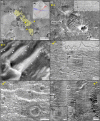
(a) HiRISE image showing the different albedo of the fractured ridges and smooth ridges. (b) Close‐up showing details of the SRs. (c)–(d) HiRISE perspective views of the FR/SR transition. Note the same orientations and the superposition of boulders from the nearby impacts. HiRISE, High Resolution Imaging Science Experiments; FR, fractured ridge; SR, smooth ridges.
Figure 3
HiRISE image showing details of the smooth ridges . ((a)–(b)) SRs are only found in eroded/old craters and never in pristine/young ones which can be filled by TARs. Note the cratered appearance of the SRs and the stratigraphic relationship with the NE‐SW oriented TARs/mini‐TARs. (c) Close‐up of intracrater SRs overlaid by boulders from nearby younger impacts. ((d)–(e)) SRs crossing the impact ejecta blankets showing two crests (arrowed) cut by impacts. See Figures. 1 and S8 for location. (f) Double crest structures can be locally detectable on HiRISE DTM (Profile EF). TARs, transverse aeolian ridges; HiRISE, High Resolution Imaging Science Experiments; SR, smooth ridges.
Figure 4
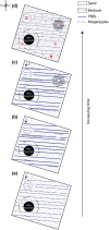
Schematic drawing showing the interpreted evolution of the megaripple‐PBR system. (a) Deposition of the megaripples (dotted lines) in the Amazonian. (b) Formation of the PBRs (solid lines): megaripples overlie the PBRs or are locally detached. (c) New impacts strike the surface covering the megaripple/PBR pattern. (d) Erosional event: megaripples are eroded, but locally preserved were covered/sheltered. Subsequent winds deposit TARs/mini‐TARs (red lines). PBRs, Periodic Bedrock Ridges; TARs, transverse aeolian ridges.
Figure 5
PBR‐megaripple systems on (a) Mars, HiRISE image showing megaripples detaching from PBRs in the study area (see Figure 1a for location) and (b) Earth, Puna (Argentina; cf., Hugenholtz et al., 2015). Dark‐toned megaripples are found downwind of bright PBRs (image from Google Earth). (c) HiRISE image of a similar PBR‐megaripple arrangement in Candor Chasma (Mars). PBRs, Periodic Bedrock Ridges; HiRISE, High Resolution Imaging Science Experiments.
Similar articles
- Orbital and In-Situ Investigation of Periodic Bedrock Ridges in Glen Torridon, Gale Crater, Mars.
Stack KM, Dietrich WE, Lamb MP, Sullivan RJ, Christian JR, Newman CE, O'Connell-Cooper CD, Sneed JW, Day M, Baker M, Arvidson RE, Fedo CM, Khan S, Williams RME, Bennett KA, Bryk AB, Cofield S, Edgar LA, Fox VK, Fraeman AA, House CH, Rubin DM, Sun VZ, Van Beek JK. Stack KM, et al. J Geophys Res Planets. 2022 Jun;127(6):e2021JE007096. doi: 10.1029/2021JE007096. Epub 2022 May 26. J Geophys Res Planets. 2022. PMID: 35865672 Free PMC article. - Oxia Planum: The Landing Site for the ExoMars "Rosalind Franklin" Rover Mission: Geological Context and Prelanding Interpretation.
Quantin-Nataf C, Carter J, Mandon L, Thollot P, Balme M, Volat M, Pan L, Loizeau D, Millot C, Breton S, Dehouck E, Fawdon P, Gupta S, Davis J, Grindrod PM, Pacifici A, Bultel B, Allemand P, Ody A, Lozach L, Broyer J. Quantin-Nataf C, et al. Astrobiology. 2021 Mar;21(3):345-366. doi: 10.1089/ast.2019.2191. Epub 2021 Jan 5. Astrobiology. 2021. PMID: 33400892 Free PMC article. - Morphological and Spectral Diversity of the Clay-Bearing Unit at the ExoMars Landing Site Oxia Planum.
Mandon L, Parkes Bowen A, Quantin-Nataf C, Bridges JC, Carter J, Pan L, Beck P, Dehouck E, Volat M, Thomas N, Cremonese G, Tornabene LL, Thollot P. Mandon L, et al. Astrobiology. 2021 Apr;21(4):464-480. doi: 10.1089/ast.2020.2292. Epub 2021 Mar 1. Astrobiology. 2021. PMID: 33646016 - Spectroscopic study of terrestrial analogues to support rover missions to Mars - A Raman-centred review.
Rull F, Veneranda M, Manrique-Martinez JA, Sanz-Arranz A, Saiz J, Medina J, Moral A, Perez C, Seoane L, Lalla E, Charro E, Lopez JM, Nieto LM, Lopez-Reyes G. Rull F, et al. Anal Chim Acta. 2022 May 29;1209:339003. doi: 10.1016/j.aca.2021.339003. Epub 2021 Aug 31. Anal Chim Acta. 2022. PMID: 35569840 Review. - Mission Overview and Scientific Contributions from the Mars Science Laboratory Curiosity Rover After Eight Years of Surface Operations.
Vasavada AR. Vasavada AR. Space Sci Rev. 2022;218(3):14. doi: 10.1007/s11214-022-00882-7. Epub 2022 Apr 5. Space Sci Rev. 2022. PMID: 35399614 Free PMC article. Review.
Cited by
- Orbital and In-Situ Investigation of Periodic Bedrock Ridges in Glen Torridon, Gale Crater, Mars.
Stack KM, Dietrich WE, Lamb MP, Sullivan RJ, Christian JR, Newman CE, O'Connell-Cooper CD, Sneed JW, Day M, Baker M, Arvidson RE, Fedo CM, Khan S, Williams RME, Bennett KA, Bryk AB, Cofield S, Edgar LA, Fox VK, Fraeman AA, House CH, Rubin DM, Sun VZ, Van Beek JK. Stack KM, et al. J Geophys Res Planets. 2022 Jun;127(6):e2021JE007096. doi: 10.1029/2021JE007096. Epub 2022 May 26. J Geophys Res Planets. 2022. PMID: 35865672 Free PMC article.
References
- Arvidson, R. E. , Ashley, J. W. , Iii, J. F. B. , Chojnacki, M. , Cohen, J. , Economou, T. E. , et al. (2011). Opportunity Mars Rover mission: Overview and selected results from Purgatory ripple to traverses to Endeavour crater. Journal of Geophysical Research Planets, 116(E7), 1–33. 10.1029/2010JE003746 - DOI
- Balme, M. , Berman, D. C. , Bourke, M. C. , & Zimbelman, J. R. (2008). Transverse Aeolian Ridges (TARs) on Mars. Geomorphology, 101(4), 703–720. 10.1016/j.geomorph.2008.03.011 - DOI
- Balme, M. , Robson, E. , Barnes, R. , Butcher, F. , Fawdon, P. , Huber, B. , et al. (2017). Surface‐based 3D measurements of small aeolian bedforms on Mars and implications for estimating ExoMars rover traversability hazards. Planetary and Space Science, 101(April), 1–15. 10.1016/j.pss.2017.12.008 - DOI
- Berman, D. C. , Balme, M. R. , Michalski, J. R. , Clark, S. C. , & Joseph, E. C. S. (2018). High‐resolution investigations of Transverse Aeolian Ridges on Mars. Icarus, 312(September), 247–266. 10.1016/j.icarus.2018.05.003 - DOI
- Beyer, R. A. , Alexandrov, O. , & McMichael, S. (2018). The Ames Stereo Pipeline: NASA's open source software for deriving and processing terrain data. Earth and Space Science, 5(9), 537–548. 10.1029/2018EA000409 - DOI
LinkOut - more resources
Full Text Sources
Other Literature Sources
Miscellaneous


