On the earliest Acheulean in Britain: first dates and in-situ artefacts from the MIS 15 site of Fordwich (Kent, UK) - PubMed (original) (raw)
. 2022 Jun 22;9(6):211904.
doi: 10.1098/rsos.211904. eCollection 2022 Jun.
Affiliations
- PMID: 35754990
- PMCID: PMC9214292
- DOI: 10.1098/rsos.211904
On the earliest Acheulean in Britain: first dates and in-situ artefacts from the MIS 15 site of Fordwich (Kent, UK)
Alastair Key et al. R Soc Open Sci. 2022.
Abstract
Northern Europe experienced cycles of hominin habitation and absence during the Middle Pleistocene. Fluvial gravel terrace sites in the east of Britain and north of France provide a majority of the data contributing to this understanding, mostly through the presence or absence of stone-tool artefacts. To date, however, relatively few sites have been radiometrically dated, and many have not been excavated in modern times, leading to an over-reliance on selectively sampled and poorly dated lithic assemblages. This includes Fordwich (Kent, UK), where over 330 bifaces were discovered through industrial quarrying in the 1920s. Here, we present the first excavation and dating of artefacts discovered in situ at Fordwich, alongside their technological analysis and relationship to those previously recovered. The site is demonstrated to retain deposits of Lower Palaeolithic artefacts, with 251 flakes, scrapers and cores identified to date. Infrared-radiofluorescence (IR-RF) dating of feldspar reveals 112 artefacts to have come from levels dating to at least 570 ± 36 to 513 ± 30 thousand years ago (ka) and are most plausibly assigned to an MIS 14 deposition, with artefacts produced during MIS 15 (approx. 560-620 ka). Indeed, these IR-RF samples provide minimum ages for artefacts. Combined with evidence from exposures linked to the original quarrying activities, a similar MIS 15 age is suggested for the more than 330 handaxe artefacts discovered in the 1920s. The remaining excavated artefacts come from levels dated to between 347 ± 22 and 385 ± 21 ka (MIS 10 or 11), with this later age interpreted to reflect post-MIS 14 deposition by substrate gullying and solifluction. These data demonstrate Fordwich to be one of the earliest Palaeolithic sites in northwestern Europe, and to retain the only large Acheulean handaxe assemblage directly dated to pre-MIS 13. Thus, Fordwich is determined to be a crucial piece of the pre-Anglian Palaeolithic puzzle in northern Europe.
Keywords: Acheulean; Lower Palaeolithic Britain; Middle Pleistocene; Quaternary gravel terrace; handaxe; small lithic technology.
© 2022 The Authors.
Conflict of interest statement
We declare we have no competing interests.
Figures
Figure 1.
The location of Fordwich within Kent (UK) alongside an example of a handaxe discovered during quarrying in the 1920s. Red dots indicate Lower Palaeolithic sites; yellow dots indicate major towns or cities.
Figure 2.
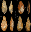
Four of the handaxes recovered from Fordwich Pit during the 1920s. Note that three display thick side profiles, elongated forms, and are relatively lightly worked (reduced) character (i.e. a, c and d could be considered ‘crude’). The fourth (b) is more heavily worked.
Figure 3.
Trenches A (right (a)) and B (left (a)) following the 2020 fieldwork. Our trenches largely confirm Smith's [2] account of the stratigraphy within the main gravel. The upper main gravel returned a younger MIS 10/11 age compared with the lower main gravel dated to 570–513 ka. We interpret this younger age to reflect reworking of these upper gravels by slope processes, including gullying and solifluction, which accords with the site's position on the edge of the valley (i.e. the artefacts recovered from these layers still probably represent MIS 15 hominin activities). (b) depicts one of the two sections exposed by Bridgland et al. [7]. Note the loam and upper gravel, which is absent at Trench A and B, but accords with Smith's [2] description of the site. (b) is also at a different scale to (a), with the former's sediment being approximately three times as deep. In both (a) and (b), yellow circles indicate the location of the IR-RF samples detailed in table 2, while the numbers refer to the sample numbers in the same table. (c) shows a basic schematic depiction of the southern side of the Stour Valley at Fordwich. Terrace 3 (T3) bears the gravels containing the present artefacts and IR-RF samples at an altitude of 41 m OD. Note that the perspective in (a) makes the IR-RF samples in the middle non-excavated section appear lower relative to those at the back of the excavation. The gravels are also inclined to the right, such that layers are approximately 15 cm higher in Trench A than B. It is plausible that the lower sand layer in the 2020 excavation aligns with the lower sand layer in the 1998 exposure (this could not be verified at present due to sediment build-up at the base of the exposure preventing access for sampling). See electronic supplementary material, figures S1 and S2 for more detail.
Figure 4.
IR-RF curves obtained from sample L-Eva 2286. The red signal marks the natural IR-RF signal, measured for 5000s at 70°C. The green signal shows the regenerated IR-RF curve, that was detected during beta-irradiation after the aliquot was bleached. During the prior bleaching procedure, the IR-RF-related traps were emptied, and hence, the signal intensity was raised to its maximum level (high trapping probability per time).
Figure 5.
IR-RF De-distribution obtained from sample L-Eva 2286.
Figure 6.
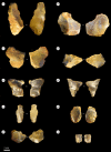
Flake artefacts from the 2020 excavations at Fordwich with varying levels of taphonomic damage. For example, flakes (c) and (d) were scaled at rounding level 4 and flake (h) was scaled at level 2.
Figure 7.
Examples of retouched pieces and a core from Fordwich Pit. The double pointed retouched implement is in the top left (a) while the largest of the scrapers can be seen in the bottom left (b). The largest core is on the right (c). See the electronic supplementary material, information for three-dimensional models of the core and double-pointed implement.
Figure 8.
Flakes displaying features characteristic of potentially having been removed using soft-hammer percussion. The flake on the left was recovered from within the approximately 542 ka dated sand layer.
Similar articles
- Early evidence of Acheulean settlement in northwestern Europe--la Noira site, a 700,000 year-old occupation in the center of France.
Moncel MH, Despriée J, Voinchet P, Tissoux H, Moreno D, Bahain JJ, Courcimault G, Falguères C. Moncel MH, et al. PLoS One. 2013 Nov 20;8(11):e75529. doi: 10.1371/journal.pone.0075529. eCollection 2013. PLoS One. 2013. PMID: 24278105 Free PMC article. - The oldest Homo erectus buried lithic horizon from the Eastern Saharan Africa. EDAR 7 - an Acheulean assemblage with Kombewa method from the Eastern Desert, Sudan.
Masojć M, Kim JY, Krupa-Kurzynowska J, Sohn YK, Ehlert M, Michalec G, Cendrowska M, Andrieux E, Armitage SJ, Szmit M, Dreczko E, Kim JC, Kim JS, Lee GS, Moska P, Jadain MA. Masojć M, et al. PLoS One. 2021 Mar 23;16(3):e0248279. doi: 10.1371/journal.pone.0248279. eCollection 2021. PLoS One. 2021. PMID: 33755675 Free PMC article. - New luminescence ages for the Galería Complex archaeological site: resolving chronological uncertainties on the acheulean record of the Sierra de Atapuerca, northern Spain.
Demuro M, Arnold LJ, Parés JM, Pérez-González A, Ortega AI, Arsuaga JL, Bermúdez de Castro JM, Carbonell E. Demuro M, et al. PLoS One. 2014 Oct 22;9(10):e110169. doi: 10.1371/journal.pone.0110169. eCollection 2014. PLoS One. 2014. PMID: 25338076 Free PMC article. - Elongation as a factor in artefacts of humans and other animals: an Acheulean example in comparative context.
Gowlett JA. Gowlett JA. Philos Trans R Soc Lond B Biol Sci. 2013 Oct 7;368(1630):20130114. doi: 10.1098/rstb.2013.0114. Print 2013 Nov 19. Philos Trans R Soc Lond B Biol Sci. 2013. PMID: 24101633 Free PMC article. Review. - Pleistocene glaciation of Fenland, England, and its implications for evolution of the region.
Gibbard PL, West RG, Hughes PD. Gibbard PL, et al. R Soc Open Sci. 2018 Jan 24;5(1):170736. doi: 10.1098/rsos.170736. eCollection 2018 Jan. R Soc Open Sci. 2018. PMID: 29410798 Free PMC article. Review.
Cited by
- Bone tools, carnivore chewing and heavy percussion: assessing conflicting interpretations of Lower and Upper Palaeolithic bone assemblages.
Parfitt SA, Bello SM. Parfitt SA, et al. R Soc Open Sci. 2024 Jan 3;11(1):231163. doi: 10.1098/rsos.231163. eCollection 2024 Jan. R Soc Open Sci. 2024. PMID: 38179084 Free PMC article. - Taphonomic and technological analyses of Lower Palaeolithic bone tools from Clacton-on-Sea, UK.
Parfitt SA, Lewis MD, Bello SM. Parfitt SA, et al. Sci Rep. 2022 Nov 23;12(1):20222. doi: 10.1038/s41598-022-23989-x. Sci Rep. 2022. PMID: 36418870 Free PMC article.
References
- Dewey H, Smith RA. 1924. Flints from the Sturry gravels, Kent. Archaeologia 74, 117-136. (10.1017/S0261340900013096) - DOI
- Smith RA. 1933. Implements from high-level gravel near Canterbury. Proc. Prehist. Soc. East Angl. 7, 165-170. (10.1017/S095884180002665X) - DOI
- Wymer J. 1968. Lower Palaeolithic archaeology in Britain. New York, NY: Humanities Press Inc.
- Roe DA. 1968. British Lower and Middle Palaeolithic handaxe groups. Proc. Prehist. Soc. 34, 1-82. (10.1017/S0079497X00013840) - DOI
- Roe DA. 1981. The Lower and Middle Palaeolithic periods in Britain. London, UK: Routledge and Kegan Paul.
LinkOut - more resources
Full Text Sources


