Airborne gamma-ray mapping using fixed-wing vertical take-off and landing (VTOL) uncrewed aerial vehicles - PubMed (original) (raw)
Airborne gamma-ray mapping using fixed-wing vertical take-off and landing (VTOL) uncrewed aerial vehicles
Ewan Woodbridge et al. Front Robot AI. 2023.
Abstract
Low-cost uncrewed aerial vehicles (UAVs) are replacing manned aircraft for airborne radiation mapping applications such as nuclear accident response scenarios or surveying ore deposits and mine sites because of their cost-effectiveness and ability to conduct surveys at lower altitude compared to manned counterparts. Both multi-rotor UAVs and fixed-wing UAVs are well established technologies for aerial radiation mapping applications, however, both also have drawbacks: multi-rotor UAVs are very limited in flight time and range, and fixed-wing UAVs usually require facilities for take-off and landing. A compromise solution is introduced in this work, using a fixed-wing vertical take-off and landing (VTOL) UAV that combines the flexibility of a multi-rotor UAV with the range and flight time of a fixed-wing UAV. The first implementation of a VTOL with radiation mapping capabilities is presented, based on a commercial WingtraOne UAV augmented with CsI scintillator and CZT semiconductor gamma spectrometers. The radiation mapping capabilities of the prototype are demonstrated in a case study, mapping the distribution of radionuclides around the South Terras legacy uranium mine in the south of England, United Kingdom, and the results are compared with previous studies using multi-rotor and manned aircraft to survey the same area.
Keywords: UAV (unmanned aerial vehicle); VTOL (vertical takeoff and landing); gamma radiation; naturally occurring radioactive material (NORM); radiation mapping; radioactivity.
Copyright © 2023 Woodbridge, Connor, Verbelen, Hine, Richardson and Scott.
Conflict of interest statement
The authors declare that the research was conducted in the absence of any commercial or financial relationships that could be construed as a potential conflict of interest.
Figures
FIGURE 1
Block diagram of the radiation mapping payload, featuring a 1 cm3 CZT semiconductor detector, and a 36.1 cm3 CsI(Tl) scintillator detector.
FIGURE 2
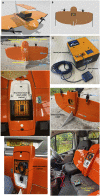
Figures showing the Wingtra-AARM system. (A,B) show CAD designs of the AARM within the Wingtra payload. (C) shows the main features of the Wingtra one Gen one fixed-wing VTOL. (D) shows the AARMv4 detector unit that mounts onto the payload plate seen in (E–G). (H) shows the AARM unit charging from a ground vehicle in the field.
FIGURE 3
Example flight plan for the South Terras site that is pre-determined by the pilot using the Wingtra Pilot app.
FIGURE 4
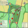
Location of the South Terras legacy uranium mine and refinery site situated 1.5 km South-West of the village of St Stephen in Cornwall.
FIGURE 5
Map of the five flights completed around South Terras by the WingtraOne. Flight line spacing of 20 m was used for each flight. All flights were conducted at an altitude of 70 m.
FIGURE 6
Dose conversion function for the Hamamatsu C12137-01 spectrometer in the energy range 0–3 MeV under planar environmental source conditions. Data from (Tsuda et al., 2018).
FIGURE 7
Interpolated map of the full spectrum dose rate, sampled at 2 Hz, across the survey region covered by the 5 flights.
FIGURE 8
Interpolated map of the unscattered equivalent dose rates from the windowed 2 Hz spectral data for 40K and equivalent 238U. The dose rate presented here for the 238U window is formed from a sum of the windows centred at 609, 1,120 and 1764 keV.
FIGURE 9
Relative Uncertainty plot for the extracted peak intensities for 40K and equivalent 238U. Measurement points with insufficient peak intensities to be discernible within the spectrum are removed. The points shown in each plot were used to produce the interpolated maps in Figure 8.
FIGURE 10
South Terras site map with plotted dose rates. The dotted contours outline the full spectrum dose rate determined from this UAV survey, representing a zoomed-in version Figure 7. The ground surveys are are plotted as coloured markers. Locations marked denote measurements reported by Martin et al. (2015) in _μ_Sv/h, which are presumed contact dose rates. Locations marked
 denote measurements made in this survey in _μ_Sv/h at a height of 1.0 ± 0.2 m above the surface. Locations marked
 denote measurement points in common between Martin et al. (2015) and this survey, and both measurements are shown for each in their respective colours. Locations marked
 represent 7 sample points reported by Foulkes et al. (2017). Locations marked
 represent 2 sample points reported by Rosas-Moreno et al. (2023). Map available in vector format as open data.
FIGURE 11
Comparison of the area covered by this study and those by Martin et al. (2015). The Wingtra covered approximately 15× the area, in half the time taken to survey the areas outlined in red by Martin et al. (2015).
Similar articles
- Design, Analysis, and Testing of a Hybrid VTOL Tilt-Rotor UAV for Increased Endurance.
Panigrahi S, Krishna YSS, Thondiyath A. Panigrahi S, et al. Sensors (Basel). 2021 Sep 7;21(18):5987. doi: 10.3390/s21185987. Sensors (Basel). 2021. PMID: 34577196 Free PMC article. - Upscaling ground-based backpack gamma-ray spectrometry to spatial resolution of UAV-based gamma-ray spectrometry for system validation.
Altfelder S, Preugschat B, Matos M, Kandzia F, Wiens B, Eshmuradov O, Kunze C. Altfelder S, et al. J Environ Radioact. 2024 Mar;273:107382. doi: 10.1016/j.jenvrad.2024.107382. Epub 2024 Jan 23. J Environ Radioact. 2024. PMID: 38266319 - Thrust Vectoring Control of a Novel Tilt-Rotor UAV Based on Backstepping Sliding Model Method.
Yu Z, Zhang J, Wang X. Yu Z, et al. Sensors (Basel). 2023 Jan 4;23(2):574. doi: 10.3390/s23020574. Sensors (Basel). 2023. PMID: 36679369 Free PMC article. - Landing and take-off capabilities of bioinspired aerial vehicles: a review.
Hammad A, Armanini SF. Hammad A, et al. Bioinspir Biomim. 2024 Mar 26;19(3). doi: 10.1088/1748-3190/ad3263. Bioinspir Biomim. 2024. PMID: 38467070 Review. - Threats from and Countermeasures for Unmanned Aerial and Underwater Vehicles.
Khawaja W, Semkin V, Ratyal NI, Yaqoob Q, Gul J, Guvenc I. Khawaja W, et al. Sensors (Basel). 2022 May 20;22(10):3896. doi: 10.3390/s22103896. Sensors (Basel). 2022. PMID: 35632303 Free PMC article. Review.
Cited by
- Combined Solid-State LiDAR and Fluorescence Photogrammetry Imaging to Determine Uranyl Mineral Distribution in a Legacy Uranium Mine.
Scott TB, Woodbridge E, Verbelen Y, Ryan Tucker M, Kong L, El-Turke A, Megson-Smith D, Malchow R, Burnley PC. Scott TB, et al. Sensors (Basel). 2025 Mar 27;25(7):2094. doi: 10.3390/s25072094. Sensors (Basel). 2025. PMID: 40218612 Free PMC article.
References
- Berger M. (2010). Nist XCOM: Photon cross sections database. Available at: http://www.nist.gov/pml/data/xcom/index.cfm .
- Cai C., Carter B., Srivastava M., Tsung J., Vahedi-Faridi J., Wiley C. (2016). “Designing a radiation sensing UAV system,” in 2016 IEEE Systems and Information Engineering Design Symposium (SIEDS), 29-29 April 2016, 165. 10.1109/SIEDS.2016.7489292 - DOI
- Connor D. (2021). “Evaluating the use of low-cost and lightweight unoccupied aerial systems in environmental radiation mapping,” (United Kingdom: University of Bristol; ). Ph.D. thesis.
- Connor D., Martin P. G., Scott T. B. (2016). Airborne radiation mapping: Overview and application of current and future aerial systems. Int. J. Remote Sens. 37, 5953–5987. 10.1080/01431161.2016.1252474 - DOI
- Connor D., Megson-Smith D., Wood K., Mackenzie R., Connolly E., White S., et al. (2022). Mapping of post-disaster Environments using 3D Backprojection and iterative inversion methods Optimised for limited-pixel gamma Spectrometers on unoccupied aerial systems (UAS). Tech. rep., Copernicus Meetings.
LinkOut - more resources
Full Text Sources


